Russian military personnel load a missile onto a transport vehicle. Nuclear powers spent a record of $119 billion on their arsenals in 2025, according to ICAN. Credit: Russian Defence Ministry / EPA / AMNA.
Nuclear powers spent a record of $119 billion on arsenals in 2025, as the world’s nine nuclear-armed states significantly increased their weapons-related expenditure, according to a new report by the International Campaign to Abolish Nuclear Weapons (ICAN).
The figure marks a 19 percent rise from 2024, with nuclear powers spending $17 billion more than the previous year. ICAN warns that the increase reflects a broader trend that is likely to continue for decades. The report covers the United States, Russia, China, the United Kingdom, France, India, Israel, Pakistan, and North Korea.
ICAN warns of a new nuclear arms race
As per the Nobel Peace Prize-winning organization, rising geopolitical tensions are fueling what it describes as a new nuclear arms race. ICAN has also raised concerns over the possible role of artificial intelligence in nuclear decision-making, warning that AI could accelerate the process leading to the potential use of nuclear weapons.
Susie Snyder, ICAN’s program coordinator and one of the report’s authors, described the figures as deeply troubling. Speaking to Agence France-Presse, she declared it’s deeply terrifying.
US spent more than all other nuclear powers combined
The United States remained the world’s largest nuclear spender in 2025, allocating $69.2 billion to its arsenal. That was $12.4 billion more than in 2024 and more than the combined total spent by the other eight nuclear-armed states. China ranked second, with estimated spending of $13.5 billion. The United Kingdom followed with $12.6 billion, while Russia spent $9.5 billion.
According to ICAN, the nine nuclear-armed countries have spent over $470 billion on their arsenals in the past five years.
Long-term nuclear programs could last beyond 2100
The report reveals that nuclear weapons spending is expected to continue rising as countries modernize and maintain their arsenals over time. ICAN points to spending plans in the United States, the United Kingdom, and France that could necessitate billions of dollars through the end of the century. Other nuclear-armed states are also developing weapons systems designed to remain in service for decades.
In the United States, the planned Sentinel intercontinental ballistic missile program is expected to remain operational beyond 2100. Based on the report, expanded US production of plutonium pits could support nuclear warheads until at least 2120. ICAN estimates that the United States alone is expected to spend nearly $1 trillion on its nuclear arsenal between 2025 and 2034.
Report compares record spending by nuclear powers with global needs
The scale of spending, ICAN says, comes as governments face pressing global challenges, including health care, food security, and humanitarian needs. According to Snyder, the amount spent by nuclear-armed states in 2025 would have been enough to fund the United Nations budget dozens of times over. She added that a single day of nuclear weapons spending could have guaranteed food security for two million people last year.
The report argues that nuclear-armed countries are committing public resources to weapons that, according to Snyder, they “could not use without committing a war crime.” ICAN maintains that the latest figures show that nuclear weapons spending is becoming a long-term strategic priority rather than a short-term response to current global tensions.
Τhe decommissioned naval ship A/B Folegandros Is being scuttled using controlled explosive charges. Video screenshot.
In the coastal waters of Chania, Crete, decommissioned navy vessels are being scuttled to create Greece’s first highly regulated, wreck-based scuba diving park.
The ambitious underwater project by the municipality of Apokoronou at Omprogialos already features 44 deployed artificial reefs alongside the decommissioned Hellenic Navy vessel Nestor. On Wednesday, the park adds its newest centerpiece: the decommissioned naval ship A/B Folegandros, which is scheduled to be scuttled using controlled explosive charges.
Θάλασσα Χανίων Το ανατίναξαν για καλό σκοπό… Στον Ομπρόσγιαλο Χανίων δημιουργείται το πρώτο οργανωμένο καταδυτικό πάρκο της Ελλάδας. Μετά τους 44 τεχνητούς υφάλους και το «Νέστωρ», βυθίζεται σήμερα το παροπλισμένο «Α/Β Φολέγανδρος» σε βάθος περίπου 25 μέτρων. pic.twitter.com/OjcV1SIXvY
— Αντώνης Νταλακογεώργος (@Adalakogeorgos) June 10, 2026
Hellenic Coast Guard vessels and an elite Navy Underwater Demolition Command (OYK) unit are currently on-site overseeing the operation. Following detonation, the vessel will settle on the seabed at a depth of approximately 25 meters (82 feet).
To ensure public safety, maritime authorities have enacted stringent security measures across the broader Ompros Gialos sea area. A strict multi-kilometer exclusion zone has been established, completely banning the approach, anchoring, or transit of any vessel within a one-kilometer radius of the scuttling site. The Hellenic Coast Guard has been actively patrolling the perimeter since the early hours of the morning and will maintain surveillance until the operation is fully finalized.
A scuba diving park
The scuttling of the Folegandros is a pivotal step toward finalizing the Apokoronou Diving Park, a cornerstone project in the region’s strategic push to develop high-end, niche tourism markets. The diving park, which will be owned and operated directly by the Municipality of Apokoronas, features three distinct underwater routes designed for varying exploration levels:
Route 1: The Eco-Trail — Navigating through the network of 44 artificial reefs, submerged at a highly accessible depth of 9 to 10 meters (30–33 feet)
Route 2: The Nestor Wreck — Centered around the previously scuttled Hellenic Navy ship
Route 3: The Folegandros Deep Wreck — Descending to the newly scuttled vessel at 25 meters, geared toward intermediate and advanced divers
A catalyst for alternative tourism
Local officials aim to have the diving park fully operational by the end of the current 2026 tourism season.
Hailed as one of the most significant alternative tourism infrastructures in Chania and the wider island of Crete, the park is projected to become a premier hotspot for international and domestic diving enthusiasts. Beyond the economic boost, this dedicated “shipwreck museum” is designed to act as a marine sanctuary, generating a highly positive ecological footprint by fostering localized marine biodiversity and promoting sustainable eco-tourism in the Aegean.
Lake Marathon Dam in Greece. The country’s aging water networks are facing growing pressure from water loss, drought, and rising investment needs. Credit: Vitaly / Wikimedia Commons / CC BY-SA 3.0
Water loss in parts of Greece’s aging water networks exceeds 50 percent, according to a new analysis by EY-Parthenon, highlighting the urgent need for infrastructure upgrades and a new approach to water management.
The report warns that climate pressures, prolonged drought, declining water reserves, and outdated infrastructure are pushing Greece’s water sector to a critical turning point.
Greece’s water networks are now increasingly viewed as core national infrastructure with direct implications for economic stability, environmental protection, and long-term public planning.
A loss of over 50% in some of Greece’s aging water networks
According to EY-Parthenon, the global strategy consulting arm of Ernst & Young (EY), water losses across Greek networks exceed 30 to 40 percent in many cases, while certain areas face losses of over 50 percent. The high losses reflect aging infrastructure, insufficient maintenance, limited monitoring of water flows and consumption data, and the need for more efficient management systems.
The analysis also notes that water reuse remains extremely limited in Greece, at around two percent. At the same time, irrigation accounts for approximately 85 percent of total water consumption. More than 70 percent of irrigation water comes from underground reserves, which highlights the need for more efficient resource use and a more pronounced shift toward circular water management.
Fragmented water sector faces growing pressure in Greece
EY-Parthenon identifies fragmentation as one of the main weaknesses of Greece’s water management sector. The market includes 129 municipal water and sewage companies, more than 450 irrigation organizations, and a broad network of local authorities. This dispersed operating model makes coordination harder, limits economies of scale, and slows modernization projects.
The challenge becomes more urgent as the sector faces increasing demands related to resilience, governance, service quality, and regulatory compliance. Numerous smaller providers remain under financial pressure, as revenue from water bills often does not fully cover operating costs or support major infrastructure investments.
Greece’s water infrastructure needs reach €10 billion
Although the sector faces serious structural problems, EY-Parthenon sees significant room for investment in Greece’s water market. The country’s medium- and long-term infrastructure needs stand at around €10 billion ($11.5 billion). Meanwhile, Greece’s two largest water companies have planned or ongoing investments that exceed €3 billion ($3.46 billion).
These investments focus on network upgrades, expansion, modernization, and efficiency improvements. According to the report, investor confidence in the sector also continues to rise, as shown by the recent market performance of listed companies operating in the water industry.
New rules could reshape Greece’s aging water networks
Changes in Greece’s regulatory framework could further transform the sector. The expanded role of the Regulatory Authority for Waste, Energy and Water (RAAEY), stricter European obligations on wastewater management, and efforts to reduce fragmentation are shifting reform from discussion to implementation.
These changes create opportunities, but they also impose new requirements on water providers. They call for greater transparency, more rigorous reporting obligations, improved accountability, and more reliable long-term planning. EY-Parthenon emphasizes that the sector’s future challenges are not only technical. They also involve financial sustainability, pricing policies, digital transformation, investment priorities, and cooperation between public and private stakeholders.
The Vine of Pausanias is tangled and about 100 meters long. Foresters believe it to be about 3,000 years old. Photo credit: Kalavryta Municipality
When ancient Greek geographer Pausanias sat down to rest beneath the shade of the giant vine, he was unaware it was probably the oldest in the world.
It was approximately 160 AD when Pausanias (110-180 AD) enjoyed the shade of the ancient vine (Vitis vinifera) in the modern-day Peloponnesian community of Sella Pagrati on the Tripoli-Kalavryta national highway.
Today, the Vine of Pausanias is a tourist attraction on the border of the Arcadia and Achaia prefectures within the courtyard of the Agios Nikolaos church. According to agriculturalists, it is estimated to be about three thousand years old.
In the book, Food and History, Vol 11 (pp. 27-34) by Boursiquot, Lacombe, Laucou, and Bakasietas, there is a description of the ancient Greek vine:
“In order to contribute to the development of knowledge on the ampelographic heritage and the viticultural genetic resources of Greece, we have characterized the so-called ‘Pausanias’ vine at the ampelographic and molecular level. This vine is located in the center of the Peloponnese (village of Pagrati, Prefecture of Achaia). It is named and listed under the name of ‘Vine of Pausanias,’ Greek geographer of the 2nd century AD, even if its origin and its real age are not really known. The results of the analyses show that it is not an ancient Greek grape variety but a lambrusca (Vitis vinifera subsp. sylvestris), whose specificity lies in the fact that the strain has been maintained naturally for a very long time, and probably for several centuries, without any particular human intervention. In this respect, and by its spectacular development, it is certainly a unique and quite exceptional example.”
Although it blooms every May, the vine no longer produces fruit. It is about 100 meters (328 feet) long and has 9 shoots (trunks), which spread in a grove of hollow oak bushes (Quercus coccifera). Many of its branches have even climbed the oak bushes. It should be noted that, according to the villagers, many of the shoots were cut by the Germans during the 1941-1944 Occupation.
Pausanias went for the trout
In his book Arcadika (8.21.2), Pausanias claims he had visited the area to see if the rumor that the trout of the Aroanios River sang like the song thrush bird was true: “…here the fish of the Aroanios River are so delicious that they sing like thrushes.” (Greek: “εἰσὶ δὲ ἰχθῦς ἐν τῷ Ἀροανίῳ καὶ ἄλλοι καὶ οἱ ποικιλίαι καλούμενοι: τούτους λέγουσι τοὺς ποικιλίας φθέγγεσθαι κίχλῃ τῇ ὄρνιθι ἐοικός.”)
The ancient Greek geographer discovered that local gourmands had a metaphor to describe the flavorful Aroanios River trout. Later on, he sought the shade of the vine, which he found impressive. The villagers hosted him, providing him with a trout meal and offering him water from the nearby spring.
Ancient legends connect the Vine of Pausanias with the third of the twelve labors of Heracles, which was to capture the Ceryneian Hind, the golden-horned deer sacred to Artemis. According to the legend, while the hero was on the hunt for the deer, it reached the vine, and its long horns became tangled, enabling Heracles to capture it. Due to this myth, the location of the Vine of Pausanias had also been named Kynigari (Greek: Κυνηγάρι), meaning “hunting place” in Greek.
Protected national monument
The vine was declared a Protected Natural Monument in 1975 (Government Gazette 738/B/1975). Regarding the vine’s physical condition, the scientific committee of the ECOCITY NGO estimates that the original trunks of the plant have disappeared due to the natural deterioration of time, while their remaining lower parts, which are one to one and a half meters high and at least 50 centimeters in diameter, have dried out.
Many other shoots have emerged from the numerous branches of the roots, climbing the tree-like oak bush forms. However, ECOCITY estimates that the condition of these “trunk shoots” seems almost hopeless, suggesting that the unique natural monument could potentially permanently disappear after about three thousand years.
To avoid destruction of the Vine of Pausanias, ECOCITY has long since forwarded a request to the competent services responsible for its preservation and maintenance. This in relation to the desired cooperation with the Viticulture and Arboriculture Laboratories of the Agricultural University of Athens so that they may take immediate action to improve the vine’s physical condition and prevent its complete demise.
In May 2014, with permission granted by the Ministry of Environment, Energy, and Climate Change, the members of the scientific committee of the Western Greece Sector of ECOCITY visited the Vine of Pausanias. They extracted samples from the trunks to determine precise dating. The team consisted of foresters and agriculturalists who then sent the samples to the head of the Archaeometry Laboratory of the NCSR “Demokritos.”
Unique and distinctive genotype
Genetic analysis of the Vine of Pausanias was carried out. Twenty microsatellite markers distributed throughout the genome were studied for this purpose, and comparison with 119 Greek varieties and 762 species of wild vines was performed.
The comparison to all the varieties in the Vassal collection (over 3000) proved that the vine’s profile is of a unique and distinctive genotype.
Its age is estimated to be several centuries old, but the number cannot be definitively determined. Its flowers are only ‘male,’ meaning the vine is not fruit-bearing.
Compared to other representatives of Vitis vinifera, wild or cultivated, that exist today in the world, the Vine of Pausanias is of a particularly original genotype, probably resulting from a limited number of sexual generations which have also undergone only few cycles of vegetative multiplication. In this regard, it is certainly a fascinating model for studies on the evolution and dynamics of the vine genome.
Artist’s depiction of the Colossus of Rhodes (one of the Seven Wonders of the Ancient World). Credit: Public Domain.
Most people today know of the Colossus of Rhodes as one of the Seven Wonders of the Ancient World, but there are many little-known facts about the masterpiece that may surprise you.
The ancient island of Rhodes, the kállistin (best) of the Greek cities as historians like to call it, has long attracted the attention of the world due to its beautiful beaches, rich history, and advanced civilization that stretches far back in time.
Rhodes was a city with philosophical and other schools, conservatories, markets, stadiums, harbors, and at least 3,000 public statues.
The masterpiece of all, though, was the Colossus of Rhodes, built between 292 to 280 BC. The huge bronze statue was about 30 meters (98.4 feet) tall and portrayed the god of the Sun, Helios.
The construction of the Colossus lasted for 12 years, but the statue was destroyed a few decades later in 226 BC by an earthquake.
Lesser known facts about the Colossus of Rhodes
The Colossus of Rhodes and the Statue of Liberty
Both monuments were built as symbols of freedom, and people have made the connection between both statues since the Statue of Liberty was created.
The Statue of Liberty has been referred to as the “Modern Colossus” and stands just a little higher at 34 meters (111.5 feet) tall.
There is also a plaque inside the pedestal of the Statue of Liberty that is inscribed with a sonnet title “The New Colossus, not like the brazen giant of Greek fame.”
The debate about the statue’s feet
There has been a debate among historians about whether the statue was standing with one foot on either side of the Rhodes harbor.
Some have discounted this theory and believe that he stood in a more usual Greek statue pose on one side of the harbor.
If the Colossus of Rhodes was built with its legs straddling the harbor, then the harbor would have had to have been closed for 12 years for the initial construction, and then it would have once again been blocked for years when the statue fell.
The statue has an iron skeleton
The statue was actually built with an iron frame like a skeleton over which the Rhodians placed carved and sculptured brass plates to create the outer structure of Helios, creating his muscle and skin.
Chares of Lindos designed the Colossus of Rhodes
We owe the design of the Colossus of Rhodes to Chares of Lindos. Chares was a student of the famous sculptor Lysippus, who had previously created a 19-meter (62 foot) tall statue of Zeus.
The metal used to construct the statue later scrapped, sold
In the 7th century A.D., the Arabs conquered Rhodes and dismantled any remnant of the Colossus of Rhodes after it was toppled by an earthquake and later sold the once beautiful statue as scrap metal.
It took approximately 900 camels to carry away all the scrap metal.
Was the destruction of the Colossus the will of the gods?
Finally, Ptolemy III, the king of Egypt, offered to pay for the Colossus’ reconstruction, but the Rhodians refused because they believed that Helios, having been angered by the construction of the statue, was the one who caused the earthquake that destroyed it.
A stunningly unique phenomenon of geology in Greece: The Folded Marls near Agios Pavlos, on the island of Crete. Credit: Tony Cross.
By Tony Cross
Greece and its geology are a wonder of nature, with the nation a paradise blessed with high mountains, blue seas, and over six thousand islands. But it’s all a big geological accident, the result of millions of years of violent earth movements on a planetary scale.
Geology in Greece: in the beginning…
The story of Greece and its geology begins around 250 million years ago when the continents had all come together into one single land mass that geologists call Pangea.
The area that would one day become Greece lay on the southern shore of what would eventually become Europe and on the northern edge of a great ocean called Tethys. On the southern edge of Tethys lay the continent that would one day become Africa.
The Earth’s crust is not all the same, nor is it a single unit. The crust making up the continents is very thick—30 km to 40 km (18.6 to 24.85 miles) thick—and thicker still under mountain ranges. The crust under the oceans is quite thin, however, at only around 7 km (4.3 miles) thick.
In addition, the crust is not one single unit but is broken up into various-sized chunks known as tectonic plates. These plates move relative to one another because they are literally floating on the deformable layer of the upper mantle beneath them in much the same way that a ship floats on the sea.
In some places, these plates are moving together, and where oceanic crust is pushed into continental crust, the thinner oceanic crust is forced beneath the thicker continental crust and down into the mantle, where it begins to sink and melt. Geologists call this type of plate boundary a subduction zone.
The Greek landscape and geology that we see today is here because of a subduction zone. Without it, Greece would simply not exist.
The compressive phase
Around 150 million years ago, the great continent of Pangea started to break up. The African plate began to move northwards, and the Tethys Ocean started to shrink. The northwards movement of Africa meant that the oceanic crust beneath Tethys was subducted under the southern edge of the continental crust of Europe.
As the oceanic crust under Tethys slid beneath the continental crust of Europe, all of the rocks that had formed on the ocean floor over many millions of years were scraped off by the leading edge of the European continent. These rock scrapings, which would have been hundreds of meters thick and many kilometers long, were piled up one on top of the other on the southern edge of Europe.
This rock pile (geologists call it a nappe) was likely many kilometers thick in the end. It contained all the rocks that would eventually form Greece’s geology all piled up in the same place.
A thrust fault near Kavousi, Crete. Credit: Tony Cross.
The photo shown here is of a large sea cliff near Kavousi on Crete. The rocks on the left are a gray color with clearly defined horizontal layers. Those on the right are a greenish brown color with a nearly vertical layering. Clearly, this cliff is composed of two very different rock types.
The rocks on the left are limestones while those on the right are phyllites. The compressional forces of the subduction zone forced the phyllites over and on top of the limestones. The junction between the two (known as a thrust fault) lies roughly in the center of the picture, running diagonally up from right to left.
Millions of years of weathering and erosion have ground both sets of rocks down so that to the casual observer today, they appear to be a single unit.
The tensional phase
Around 65 million years ago, the continent of Africa finally collided with the continent of Europe and closed the Tethys Ocean forever. It would eventually be reborn as the Mediterranean Sea.
When two continental plates come together, there is no subduction since they are both too thick. Instead, the continents themselves are deformed, and mountains are created. In the west, this collision formed the Alpine mountains while in it formed the Balkan mountains in the east.
In these mountain areas, the continental collision destroyed the subduction zone, but in the area in between, where modern Greece lies, the subduction zone remained active.
Even though Africa could no longer move northwards as fast as was previously the case, the oceanic plate in the area of Greece was still sinking into the mantle. As it sank, the subduction zone itself rolled back southwards. This rollback of the subduction zone put the nappe pile under enormous tension.
When rocks are placed under tension, they break, causing normal faults. One side of the fault moves downwards on a sloping surface to relieve the tension. Normal faults often occur in parallel and in swarms leaving alternating areas of high ground with lower ground in between.
The rollback of the subduction zone caused massive parallel swarms of normal faults in the nappe pile. Because the subduction zone is fixed in the east and in the west, the rollback created an arc that is ever expanding as the rollback progresses.
A normal fault in the Corinth Canal. Credit: Tony Cross
The photo above is of a small section of the north wall of the Corinth Canal. The rocks here are nicely layered; we can see yellow, white, red, and black layers.
The two diagonal lines in these rocks are normal faults, breaks in the rocks caused by tensional forces due to the rollback of the subduction zone. The rocks to the right of each fault have dropped down relative to the rocks on the left; this is clearly visible in the displacement of the colored layers of rock.
The total vertical displacement here is only a few meters, but in the massive regional faulting that shaped Greece and its geology, displacements are measured in kilometers.
The modern topography of Greece
Looking at a topographical map of Greece today, you can see how a subduction zone, starting roughly in the area of the north Aegean and rolling back southwards in an expanding arc would create the “ripped” and “torn” appearance of Greece today. You can also see how regional faulting created the alternating series of high mountain ranges and islands, with lower plains or sea in between.
The Pindus Mountains, for example, the backbone of mainland Greece, run southeastward in a gently curving arc. On both sides are lower plains. These mountains, like so many others in Greece, are bounded by massive regional faults.
The expanding arc of the subduction zone caused extensive local faulting, too. On Crete, for example, all of the mountain ranges are bounded by faults. They stand tall because the ground around them has dropped due to faulting. Such local, fault-bounded structures are widespread in Greece.
What about the volcanoes?
There are many volcanoes in Greece—on Santorini, Milos, Nisiros, Methana, and Sousaki among others. Some are active, like Santorini; most are dormant, like Milos, and one or two are extinct, like Sousaki.
If you look closely, all the Greek volcanoes sit on an arc that parallels the arc of the subduction zone but is north of it by about 100 km.
As the oceanic plate is subducted deep into the mantle, it begins to melt. Magma from the melting plate rises to the surface where it erupts, forming volcanoes.
The hot springs of Thermoplyae (of Spartan fame) sit at one end of this volcanic arc; the hot springs of Pamukkale in Turkey sit at the other. In between are all the Greek volcanoes, formed above the spot where, deep in the mantle, the subducted oceanic crust is melting.
Greece’s geology continues to change
The subduction zone today runs in a great arc down the western side of the Ionian Islands, around the Peloponnese and south of Crete, and then curves up northwards again past Kasos, Karpathos, and Rhodes.
Greece and its geology as we see these today are not an end point, however; this is simply the way things are right now.
The subduction zone is still active, and the oceanic plate is still descending as Africa creeps northward. The subduction zone is still rolling back, and the arc is still expanding. That’s why we have so many earthquakes in Greece—we’re still being torn apart by tectonic forces.
We don’t need to worry about this too much though, as these geological processes happen on a timescale that is measured in millions of years. Chances are, that beautiful Greek beach in the travel brochure will still be there when you arrive.
There is concern that big hotel construction undermines the character of the Greek island. Credit: Greek Reporter
The Mayor of Milos, Manolis Mikelis, has issued a fierce warning against new central government legislation and aggressive corporate development, which he claims threaten to permanently disfigure one of Greece’s most visually distinct islands.
Mikelis extensively critiqued Greece’s proposed tourism zoning framework, accusing the central government of bureaucratic negligence and creating legal loopholes that favor wealthy international funds while systematically locking out local residents.
Corporate development that excludes islanders on Milos
At the heart of the crisis is a newly introduced tourism spatial plan, released online by the Ministry of Tourism. The legislation establishes strict minimum land requirements for the construction of new hotels, setting the threshold at 8, 12, or 16 stremmata (approximately 2 to 4 acres) depending on the specific zone.
Mikelis points out that because land ownership on Milos is historically fragmented, with local families generally owning plots of only 4 to 6 stremmata (about 1-1.5 acres), the law effectively bars residents from developing small, independent hospitality businesses.
“Consequently, it allows the big funds and the rich who have too much money to come in, forcing locals to sell off their property just so these businesses can operate for only seven months a year,” Mikelis warned in speaking to Greek Reporter.
The Mayor also expressed deep concern that the central government plans to issue a legislative decree to retroactively amnesty existing illegal corporate constructions. “That is the goal, and that is what we see happening,” he said, adding that his office is actively trying to block a recent influx of newly issued building permits from being executed.
Environmental violations at Sarakiniko and Mytakas
The local administration has recently been forced to take emergency legal action following severe environmental violations in some of the island’s most ecologically sensitive regions.
In the Kaminia/Sarakiniko area, an investor engaged in illegal excavations directly adjacent to the beach, destroying ancient fossils verified by the Goulandris Museum. Despite public administration inspectors declaring the project “100% illegal,” the developer ignored government-mandated restoration deadlines with zero consequences.
The municipality of Milos accuses developers of destroying the landscape of the island. Credit: Greek Reporter
Meanwhile, in Mytakas, an extension of Sarakiniko’s famous lunar-like volcanic landscapes, a large development company purchased an existing hotel with plans to construct a massive 271-bed complex featuring one hundred private swimming pools.
According to municipal records, the developer illegally excavated and shipped out eleven shiploads of pozzolan (volcanic ash) to cement factories. Local authorities intervened only when bulldozers began moving toward the public shoreline. “We went to the Supreme Court (Council of State) and we are waiting for the final decision,” Mikelis stated. “A temporary revocation of the permit has been issued, and we are awaiting the final ruling.”
The fight for the “syrmata”
Beyond environmental destruction, Mikelis is fighting a bureaucratic battle to preserve the island’s unique cultural heritage: the syrmata. These are traditional, vibrantly colored fishermen’s structures carved directly into the seaside volcanic rock across coastal villages like Klima, Mandrakia, and Fourkovouni.
The municipality is pushing for strict architectural guidelines to ensure all 350 existing structures are protected and repaired using traditional methods despite a lack of formal state recognition.
The iconic syrmata on Milos. Credit: Greek Reporter
“The syrmata were the cultural heritage of this place, showing the life of people 150 years ago,” Mikelis explained. “In order to survive, they made a hole in the rocks to store their boat and their fishing equipment so they could live off fishing and survive during the Axis occupation and long before it.”
The Mayor noted that the term originates either from dragging (syrsimo) boats into the caves, or from historical lookouts who would shout “Syrma, syrma!” (“Watch out!”) to warn workers of approaching gendarmes, as the structures were originally built without formal permits. “Venice exists inside the water, yet we as a state cannot recognize these areas as special urban settlements,” Mikelis lamented.
A united front against corporate overdevelopment
The conflict highlights a growing rift between local municipalities and the central government. In 2023, Milos completed a comprehensive local zoning plan (SCHOOAP) designed to protect its environmentally-sensitive Natura-designated areas. However, the central government overturned the environmental study to accommodate high-value corporate investments.
Speaking to Greek Reporter, Mikelis described the Ministry’s overriding framework as a “death knell” for the local small entrepreneurs who built the island’s reputation. Instead of smaller rooms tailored to the island’s cultural scale, legal loopholes are being exploited to construct massive 300-bed luxury resorts that block public beach access.
The cash-strapped municipality is currently diverting vast public funds toward legal fees to fight these investments in court, explicitly pointing to neighboring Cycladic islands that have already been devastated by anarchic overdevelopment.
Milos is not fighting alone. Mikelis concluded by vowing to form a united front with other Greek island mayors to force a rewriting of the national tourism framework. “We will use every legal remedy to convince the people who wrote these unacceptable laws not to destroy our land any further,” Mikelis said. “Our destinations shouldn’t last for just ten years and then be degraded because the beauty and unique characteristics of our islands were destroyed. Together with other mayors, we are coordinating to make our voice stronger, ensuring longevity so that when someone pays to travel here from America, Australia, or Europe, they can still find and visit these rare beauties.”
Greek Culture Minister Lina Mendoni and Turkish Culture and Tourism Minister Mehmet Nuri Ersoy. Credit: Ministry of Culture
Greece and Turkey have established a permanent cultural forum to strengthen bilateral cooperation in cultural heritage, museums, research, education, and new technologies, creating a new institutional framework for dialogue between the two countries.
The Greece-Türkiye Cultural Forum was formally established last week through a Joint Declaration signed by Greek Culture Minister Lina Mendoni and Turkish Culture and Tourism Minister Mehmet Nuri Ersoy during the forum’s inaugural session in Cappadocia. Under the agreement, the forum will meet regularly in both countries and serve as a platform for exchanging expertise and developing joint initiatives. “Culture is perhaps the deepest and most enduring field of communication between our societies,” Mendoni said.
The forum is the latest outcome of efforts to strengthen Greek-Turkish relations following the Athens Declaration on Friendship and Good Neighbourly Relations signed by Prime Minister Kyriakos Mitsotakis and President Recep Tayyip Erdogan in December 2023. It also builds on a Memorandum of Cultural Cooperation signed by the two culture ministers during the 6th Supreme Cooperation Council in Ankara.
Heritage protection and cultural cooperation between Greece and Turkey
During the forum, Mendoni outlined Greece’s approach to heritage protection, noting that Greek legislation safeguards all monuments equally—ancient, Byzantine, Ottoman, post-Byzantine and modern—regardless of their religious or cultural origin. She also stated that all are incorporated into the country’s cultural routes and tourism networks.
Furthermore, the forum featured presentations by officials and experts from both countries on the restoration and conservation of Byzantine and Ottoman monuments, heritage management, historical research, and the use of new technologies in the cultural sector. Discussions also focused on combating the illicit trafficking of cultural goods, an area in which Greece and Turkey have cooperated since signing a bilateral protocol in 2013.
“The exchange of information, the cooperation of competent services and the use of international mechanisms are crucial tools for effectively combating the illegal trafficking of cultural goods and securing their return to their place of origin,” Mendoni said. The Joint Declaration also highlights the importance of digitalization and improving public access to cultural resources through digital technologies, while encouraging closer cooperation in the use of emerging technologies in heritage management.
On the sidelines of the forum, Mendoni thanked Ersoy for Turkey’s support at UNESCO’s Intergovernmental Committee regarding the return of the Parthenon Sculptures. She noted that his confirmation that no Ottoman document ever authorized Lord Elgin’s removal of the sculptures strengthens the international case for their reunification in Athens.
A Hellenic Coast Guard vessel tows a migrant boat to the port. Credit: AMNA
Greece’s Parliament has passed a major migration bill that officially integrates the European Union’s new Pact on Asylum and Migration into domestic law. The legislation introduces stringent measures to overhaul border controls, expedite asylum applications, and fast-track the deportation of individuals whose asylum claims have been rejected.
A central element of this new framework is the establishment of offshore “return hubs.” These are transit centers located in non-EU countries where rejected asylum seekers will be transferred if their countries of origin refuse or delay their repatriation.
Minister Plevris on “return hubs” and negotiations
Migration Minister Thanos Plevris clarified that these hubs will not operate outside the law, emphasizing: “These centers will operate within the framework of European Union agreements with third countries and under the guarantees of European and international law.”
Greece is spearheading this initiative alongside Germany, Denmark, Austria, and the Netherlands. The coalition aims to sign their first bilateral agreements later this year so the hubs can become fully operational in 2027. Minister Plevris revealed that advanced talks are already underway. “The Greek government has already been in consultations with two African countries,” he stated.
The Minister also noted that these hubs are a vital tool for Greece, as partner nations frequently experience secondary migration flows—meaning migrants who initially crossed into Europe via Greek territory. He added:
“The creation of a more effective European return mechanism can act synthetically with the existing system and offer an additional innovative tool both to Greece and the remaining member states for managing returns.”
Voluntary returns and stricter detention policies
The new law expands administrative detention, increases surveillance on individuals awaiting deportation, and speeds up removals in coordination with Frontex. Minister Plevris stated that the strict new framework “is already starting to produce tangible results.”
According to Plevris, voluntary returns handled via the International Organization for Migration (IOM) have already increased by 25% since the new measures were introduced, with hundreds of undocumented individuals coming forward to express their intent to return home.
The changing migration numbers in Greece
Minister Plevris linked the accelerated asylum processes and rigid enforcement directly to a steep decline in illegal border crossings, noting that proper returns and secure borders are inherently connected: “These figures confirm that the effective management of returns, the acceleration of asylum procedures, and border protection are interconnected pillars of a cohesive migration policy.”
To demonstrate the shifting impact, Plevris provided specific data comparing past crises to current trends. Under the previous administration between 2015 and 2019, Greece saw a massive wave of 1,215,280 irregular arrivals. Since 2019, that number has dropped significantly to 197,651 total arrivals.
Furthermore, during the first five months of 2026, nationwide arrivals saw a further 31% decrease, with arrivals in the Aegean Sea plunging by 65%. However, localized pressure remains. Over the past two years, for instance, the southern islands of Crete and Gavdos have experienced a sharp rise in migrant boats arriving from Libya.
The efficiency of processing has also changed. Pending asylum applications in Greece have plummeted by roughly 80%, dropping from 142,000 in 2019 to just 28,000 today. At the same time, stricter evaluation standards have caused the international protection approval rate to fall from 71.5% to 40.7%.
Two key pillars of the new legislation
Mandatory Border Screening: Before a migrant is legally considered to have entered EU territory, they must undergo a mandatory pre-entry screening at the border. This process includes identity verification, biometric data capture, security and health checks, and cross-referencing information via the upgraded Eurodac database to track migrant movements across the EU.
Fast-Track Asylum Evaluation: The law establishes much tighter deadlines to eliminate years of bureaucratic delays. Applications flagged as “manifestly unfounded,” particularly those submitted by nationals of countries with historically low asylum approval rates, will face rapid, border-adjacent evaluations and immediate rejection.
Sack of Corinth, by Thomas Allom, 1872. Credit: Wikimedia Commons, public domain
The formation of the Roman Empire was a gradual process, unfolding over several centuries. Nevertheless, there is one specific year that we can point to as arguably the single most significant year in the formation of the Roman Empire. This was the year 146 BCE. How did the events of this year lead to the creation of the Roman Empire?
The gradual formation of the Roman Empire
In an administrative sense, the Roman Empire was founded in the year 27 BCE. This was when Octavian, the son of Julius Caesar, became the emperor. The Roman Senate recognized him as possessing overarching military power and designated him Augustus in recognition of his new position as emperor.
Octavian established reforms to the constitution, officially changing Rome into an empire. Hence, in 27 BCE, the Roman Empire came into existence. Before then, it had been a republic.
However, although it only became an empire in an administrative sense in 27 BCE, Rome already controlled a vast empire before that. In the basic sense of “a group of countries ruled by a single person, government, or country“, Rome was already an empire long before the days of Octavian.
The Roman Republic conquered most of the territory that would constitute the future Empire. Therefore, to understand how Rome became powerful, we need to examine that era.
The acquisition of territory was a gradual process that took several centuries. However, the year 146 BCE, arguably more than any other, was crucial in the formation of the Roman Empire.
The Battle of Corinth
In 146 BCE, two significant events occurred for the Romans. One of these was the Battle of Corinth, marking the culmination of the Achaean War, which lasted only a single year.
At that time, the Achaean League ruled over the Peloponnese. They had recently assimilated Sparta into the league, which troubled Rome. Both sides were concerned with the other’s expansionist tendencies. Rome had conquered Macedonia in the early part of the second century BCE and had reconquered it in 150-148 BCE.
In the final year of the war against Macedonia, the Achaean League took control of Sparta, solidifying their hold on the Peloponnese. With tensions high due to the actions of both sides, war broke out two years later, in 146 BCE.
The war did not last long. The Achaean League was woefully unprepared, both militarily and financially, for a full-scale war against Rome. The Romans quickly subdued the Greek cities, many of which took the initiative to surrender.
A Roman consul and military general named Lucius Mummius led the Romans in their siege of Corinth. This was the climax of the war. The Romans successfully defeated and utterly destroyed it. Their brutality was noted even by ancient historians. With this victory, the Romans gained direct control of all of Greece.
The Siege of Carthage
The same year, 146 BCE, also marked the climax of another war. The war in question was the Third Punic War. This was the third war between the Roman Republic and the Carthaginian Empire.
Carthage was located in modern-day Tunisia. Rome had already defeated them in the Second Punic War, which had ended in 201 BCE. One of the terms of the treaty was that Carthage was prohibited from engaging in war without Rome’s permission. This allowed Rome’s ally, Numidian king Masinissa, to repeatedly invade Carthage’s territory.
Carthage’s decision to fight back and send an army against Masinissa in 149 BCE provided the Romans with a justification for a third war against Carthage. In reality, Rome harbored animosity towards Carthage and was merely seeking an excuse to destroy it.
When the Roman army arrived, the Carthaginians offered a complete surrender. Nevertheless, the Romans persisted and besieged the city. Eventually, after considerable brutality and bloodshed, the Romans utterly destroyed their enemy.
Just like Corinth in that same year, Carthage was completely, mercilessly destroyed, and the Romans took over the territory.
How the year 146 BCE led to the creation of the Roman Empire
Given this information, 146 BCE can be regarded as vital in the creation of the Roman Empire. The Romans achieved two major victories this year: the defeat of the Achaean League and the defeat of Carthage.
Both of these victories significantly expanded the territory of the Roman Republic. Rome took over control of all of Greece and also the core territory of the Carthaginian Empire in Tunisia. Granted, this was only a tiny portion of what later became the territory of Rome’s vast empire.
However, the main impact that this year had on the formation of the Roman Empire was not the territory gained. Rather, it was the geopolitical consequences of these victories that mattered the most.
Carthage and the Achaean League were both major powers in the Mediterranean. With their defeat, Rome became the undisputed master of that part of the earth. While it still had numerous enemies to confront, it no longer had a single, major, powerful rival.
Over in Anatolia, Pergamon was friendly with Rome. Ptolemaic Egypt was also their ally, with Rome exerting considerable influence over that region. With Greece and Carthage out of their way, Rome’s position as the dominant force in the Mediterranean was firmly established. It is for that reason that we can consider 146 BCE as such a crucial year in the formation of the Roman Empire.
Homes were set on fire in Belfast. Video screenshot/Sky News
Widespread anti-immigration riots broke out across the UK on Tuesday following a particularly violent knife attack in Northern Ireland. The unrest was triggered by news that a thirty-year-old Sudanese national had been charged with attempted murder. Prime Minister Keir Starmer strongly condemned the initial attack, labeling it both “horrific” and “sickening,” while stating he has zero tolerance for such violence.
Escalation of violence in Northern Ireland
BREAKING: A bus has been set on fire in Belfast amid protests over the attempted beheading of a man pic.twitter.com/FX8maCMalK
The unrest was most intense in Northern Ireland, where masked mobs caused extensive property damage on Tuesday evening:
Belfast: Riots resulted in multiple homes, a bus, cars, and street barricades being set on fire. Northern Ireland First Minister Michelle O’Neill condemned the rioters, stating that groups of masked men were “burning families out of their homes” in acts of “outright thuggery.”
Newtownabbey & Kilkeel: Blazes spread to neighboring towns, where verified social media footage showed protesters setting several vehicles ablaze.
Wider UK: Smaller, sporadic anti-immigration protests and clashes with police were also reported in other major UK cities, including London, Glasgow, and Bangor.
A large group rioters is attacking migrant HMOs (Houses in Multiple Occupation, a form of taxpayer-funded housing for asylum seekers) in Belfast. pic.twitter.com/o9yjynArd4
Social media fueling the anti-immigration riots in the UK
The catalyst for the riots was a viral video filmed by a witness during Monday night’s attack in North Belfast. The footage depicts a man pinning a bloodied victim to the ground and repeatedly stabbing him before bystanders and police intervened. Far-right and anti-immigration accounts widely circulated the footage online to mobilize public protests.
Further update from police sources, a property has been set alight in the Lendrick Street area of Belfast.
First Minister O’Neill warned that extremist groups are dangerously exploiting a heinous crime to target and intimidate innocent people who are just trying to live their lives.
The incident occurred around 10:30 p.m. on Monday, June 8 on Canard Avenue in North Belfast. A man in his forties suffered severe wounds to his face, back, and eyes. He remains hospitalized in serious condition. Police recovered a kitchen knife at the scene.
A thirty-year-old man was arrested for attempted murder. Authorities confirmed he had traveled from Paris to Dublin before entering Northern Ireland in February 2023. He claimed asylum upon arrival and was granted legal residency in the UK until 2028.
The building of the Academy of Athens in downtown Athens. Credit: Thomas Wolf, CC-BY-SA-3-0/Wikipedia
A major international ranking has highlighted eleven Greek scientists who have made it into the global elite of research. Spanning institutions from Stanford and Columbia to the University of Crete, these researchers are recognized among the top 1,000 scientists worldwide in their respective fields.
This prestigious list is compiled annually by Research.com, a prominent educational platform and academic research portal. To compile these rankings, Research.com analyzes data from millions of scientists globally, evaluating their career achievements based heavily on a standard academic metric called the h-index.
The h-index is a metric used to measure both the productivity (how much they publish) and the impact (how often other scientists cite their work) of a researcher.
The top 11 Greek scientists
Here is a summary of the researchers making waves in the global scientific community:
1. John Ioannidis (Stanford University)
Dr. John Ioannidis. Courtesy Dr. Ioannidis
A professor of medicine at Stanford and one of the world’s most-cited scientists. He is a pioneer in “meta-research”—the study of scientific methods themselves to improve the quality and reliability of research.
2. George Yancopoulos (Regeneron Pharmaceuticals)
George Yancopoulos. Credit: Public Domain
Yancopoulos is a top biomedical scientist and the billionaire co-founder of Regeneron. He is highly recognized for developing life-saving monoclonal antibody treatments, notably used to combat viruses like Ebola.
Maniatis is a pioneer in molecular biology and biotechnology who revolutionized gene cloning techniques. His current research focuses on comprehending the molecular mechanisms behind neurodegenerative diseases such as amyotrophic lateral sclerosis (ALS), or Lou Gehrig’s disease.
Christos Pantelis. Credit: University of Melbourne
Pantelis is a professor of psychiatry who heads the Melbourne Neuropsychiatry Centre. He is a global leader in using brain imaging to study the development and structural changes associated with schizophrenia.
5. Nicholas Peppas (University of Texas at Austin)
Nicholas Peppas. Credit: University of Texas at Austin
A chemical and biomedical engineer known as the father of modern drug delivery systems, he pioneered the development of hydrogels used in oral drug delivery, contact lenses, and tissue engineering.
One of the three researchers on the list based entirely in Greece, Stoumpos is a materials chemist specializing in halide perovskites, which are highly efficient materials used to advance next-generation solar cells and electronics.
Soukoulis is a physicist who split his career between the US and Greece. He is world-renowned for his groundbreaking research on metamaterials—artificial materials engineered to manipulate light and sound waves in ways natural materials cannot.
A chemical engineering professor based in Greece, Pandis is an international authority on atmospheric chemistry and air pollution, focusing on how airborne particulate matter affects both human health and global climate change.
A physicist based in France who is a leading researcher in quantum cryptography, Diamanti develops secure quantum communication networks and protocols to protect data from future cyber threats.
10. George Paxinos (NeuRA / University of New South Wales)
George Paxinos. Credit: NeuRA
Paxinos is a world-famous neuroscientist based in Australia who mapped the human and animal brain. His highly detailed brain atlases are universally utilized by neurosurgeons and medical researchers worldwide to identify specific brain structures.
An organic chemist based in Greece whose research focuses on developing new chemical synthesis methods, his work helps streamline the creation of complex molecules used to manufacture new pharmaceuticals and advanced materials.
Photo of German troops in the burning village of Distomo. Original description: “The photo was preserved by Pantelis Karakitsis and was made well-known by Spyros Meletzis. It was found in the pocket of a German soldier held prisoner by ELAS. Depicts Germans in Distomo on fire.” Public Domain.
The massacre at Distomo remains to this day one of the most heinous crimes the Nazis committed against innocent women and children just months before the German occupying forces pulled out of Greece.
On June 10, 1944, Fritz Laufenbach, captain of the 2nd company of the 1st battalion of the 7th SS armored regiment, was ordered to move his troops from Livadia to Distomo, Steiri and Kyriaki to locate guerrillas on the western side of Helicon Mountain.
This move by the German soldiers was in retaliation for several troops whom the Greek Resistance had killed. As bait, the Nazis had used two Greek civilian trucks filled with SS men disguised as villagers. The two trucks were moving ahead of the main phalanx.
At the same time, the 10th and 11th Amphissa companies of the 3rd Battalion were directed to Distomo to meet the 2nd company. The German troops met outside Distomo without finding any resistance fighters, save for eighteen children hiding near the village. Six of the children who tried to escape were executed.
The Germans entered Distomo, and after intimidating the villagers, they discovered that there were Greek guerrillas at Steiri. The 2nd company headed toward the village, and at Litharaki near Steiri, they were ambushed by fighters from the ELAS resistance group.
The battle at Steiri was so bloody that the Germans were forced to retreat. Approximately forty of them were killed.
Cold-blooded massacre at Distomo
After the casualties they had suffered at Steiri, the Nazis entered Distomo with a clear intention of retaliation for their losses. The cold-blooded massacre of everyone they found in the village then began.
Around 600 people were killed by the Nazis in the wider region of Distomo in 1944. Public Domain.
They went from door to door, killing anyone in sight. Their fury was such that they were careless about whether they killed women or children. The slaughter lasted into the night until the Nazi troops had to return to Livadia. However, they did not leave before burning the entire village to the ground.
According to survivors describing the atrocities, SS soldiers bayoneted babies in their cribs, stabbed pregnant women, and beheaded the village priest.
However, the Germans did not stop at Distomo. The executions continued all the way back to their base, as they killed any civilian they encountered on the way. The death count in Distomo amounted to 228 of which 117 were women and 111 men while 53 were children under the age of sixteen.
According to the testimony of International Red Cross Swiss envoy George Wehrly, who arrived in Distomo a few days later, about six hundred people were killed by the Nazis in the wider region.
Haunting pictures from Distomo
Maria Padiska in mourning several months after the massacre. Public Domain.
A few months after the Distomo massacre, LIFE magazine published a haunting report on the Nazi atrocity. Under the headline “What the Germans did to Greece,” the US magazine interviewed survivors and published photos of the town in ruins.
Among the survivors was Maria Padiska, who came to be known as the “Woman of Distomo.” She passed away in March 2009 at the age of 84.
Her photo adorns the Museum of the Victims of Nazism, located at the entrance of Distomo. The museum was founded in 2005 at the site of the old primary school. It was inaugurated by then President of the Hellenic Republic Carolos Papoulias.
The total area of the museum, which is roughly about 200 square meters, is divided into two levels. On the first floor, one can see photos of all the victims, and there is also a special area with photos of the ossuary, which is located intact at the Mausoleum on Kanales Hill of Distomo.
Selected personal ornaments from Llonín Cave in northern Spain. Credit: Daniel Pérez-García de los Salmones et al. / CC BY 4.0
A collection of 22,000-year-old jewelry discovered in northern Spain is offering new insights into how Ice Age hunter-gatherers expressed identity, exchanged ideas, and maintained social networks across vast distances.
Researchers found that people living in and around Llonín Cave used shells, animal teeth, bones, and even fossils to create personal ornaments over thousands of years, revealing changing patterns of social life during the Upper Paleolithic.
The study, led by Daniel Pérez-García de los Salmones and published in PLOS One, analyzed 271 ornaments recovered from Llonín Cave in northern Spain. The cave preserves a long archaeological sequence dating from roughly 23,500 to 11,000 years ago, covering several major cultural periods of the Late Ice Age.
A cave filled with symbolic objects
The ornaments included marine shells, red deer teeth, fish vertebrae, bone fragments, and a fossilized tube worm. Most were intentionally modified and worn as pendants or beads. Researchers identified at least 17 genera and 15 species used in their production. Marine shells made up the largest share of the collection, while red deer canine teeth were the most common animal-derived ornaments.
Microscopic analysis showed that many pieces had been worn for long periods. Friction from cords, clothing, or skin leaves polish marks, grooves, and rounded edges around perforations. More than 90% of the analyzed ornaments displayed signs of use.
A new study from Llonín Cave in northern Spain suggests Ice Age hunter-gatherers used shells, animal teeth, bones, and fossils to create ornaments that expressed identity, marked social ties, and connected communities across long distances.#Archaeology#IceAge#Jewelry#Spainpic.twitter.com/DXcBNuubUJ
— Tom Marvolo Riddle (@tom_riddle2025) June 9, 2026
Researchers also found evidence that some ornaments were made inside the cave. Unfinished deer tooth pendants and partially worked animal teeth suggest that people crafted jewelry on site rather than simply acquiring finished pieces from elsewhere.
Long-distance connections across Ice Age Iberia
One of the most striking discoveries involved shells that likely originated from the Mediterranean coast. The species Tritia mutabilis does not naturally occur along the Cantabrian coast of northern Spain, where Llonín Cave is located.
Its presence suggests that people exchanged objects or maintained contact networks stretching hundreds of kilometers across the Iberian Peninsula.
The cave occupied a strategic position between the Atlantic coast, the Ebro Valley, and routes leading toward the Pyrenees. Researchers argue that these pathways helped facilitate the movement of materials, ornaments, and cultural traditions between distant groups.
From individual identity to group identity
The study found that ornament styles changed over time. During the Upper Solutrean period, around 23,500 to 22,000 years ago, jewelry showed great diversity in materials, manufacturing methods, and designs. Researchers believe these ornaments likely served as markers of individual identity and personal expression.
Later, during the Middle Magdalenian period, ornament production became more standardized. Shell beads were more uniform in size and style, and many appear to have arrived at the cave already finished.
Researchers suggest that this shift reflects larger social gatherings where ornaments may have been used to signal group membership or strengthen alliances among different communities.
A window into Ice Age society
The findings suggest that personal ornaments were far more than decorative objects. They helped communicate identity, social relationships, and cultural connections during a time when hunter-gatherer groups were spread across changing Ice Age landscapes.
According to the researchers, Llonín Cave stands out as an important site for understanding how prehistoric people used jewelry to navigate both everyday life and wider social networks. The collection shows that even 22,000 years ago, people were connected through systems of exchange, shared traditions, and symbolic communication that stretched far beyond their local communities.
AI reconstruction of a Neolithic female figurine discovered at Kanlıtaş mound. Credit: Greek Reporter Archive
Archaeologists in Turkey have uncovered four headless female figurines dating back about 8,000 years, a discovery that is offering new insight into ritual practices among some of Anatolia’s earliest farming communities.
The terracotta figurines were found at Kanlıtaş mound near the Inönü district of Eskişehir in northwestern Turkey. Excavations at the site have been conducted since 2013 under the direction of Anadolu University.
Kanlıtaş is considered one of the earliest known settlements in the region spanning modern-day Eskişehir, Afyonkarahisar, and Kütahya. Researchers say the site provides important evidence about daily life, settlement patterns, and cultural traditions during the Neolithic period.
Figurines discovered inside ancient structures
Professor Ali Umut Türkcan, who leads the excavation team and teaches archaeology at Anadolu University, said the figurines were uncovered within fill layers at the bases of rectangular buildings.
Researchers determined that the artifacts belong to the final phase of the Neolithic period. All four figurines depict women. The largest measures about 12 to 13 centimeters (5 inches) in length, while the others are approximately 5 to 6 centimeters long.
Although female figurines are common at Neolithic sites across Anatolia, the Kanlıtaş examples stand out because of their condition and context. Several were found with their heads intentionally broken off.
Eskişehir’in İnönü ilçesindeki Kanlıtaş Höyüğü’nde bulunan 8 bin yıllık 4 başsız figürün Neolitik dönem yapı ritüellerinde kullanıldığı tespit edildi. pic.twitter.com/MkBkOCI6Wt
“The presence of headless or broken-headed female figurines in spaces that appear to have been intentionally sealed suggests they may have been left as offerings during the closure of structures,” Türkcan said.
Researchers believe the figurines were deliberately deposited when buildings were abandoned or taken out of use. Similar practices have been identified at other Neolithic settlements, including Çatalhöyük in central Turkey, one of the world’s most extensively studied prehistoric sites.
Distinctive features set the figurines apart
The Kanlıtaş figurines also display characteristics that distinguish them from many other Neolithic figurines found in Turkey.
Türkcan noted that the figures place unusual emphasis on the hip area. This stylistic feature resembles female figurines discovered in parts of the Balkans, particularly regions once associated with the Neolithic Vinca culture.
The similarity suggests that communities living in different parts of southeastern Europe and Anatolia may have shared artistic traditions or symbolic ideas during the Neolithic era.
Discovery may strengthen evidence of cultural links
Researchers also pointed to possible connections between Kanlıtaş and the broader Porsuk cultural sphere of western central Anatolia. Archaeologists have long debated links between the Porsuk culture and Neolithic communities in the Balkans.
According to Türkcan, radiocarbon dating results indicate that the Porsuk culture may predate some neighboring cultural traditions. The findings could help explain how cultural influences spread between Anatolia and southeastern Europe thousands of years ago.
The discovery adds to growing evidence that Neolithic communities maintained complex social and symbolic traditions. The figurines not only provide clues about ritual behavior but may also help researchers better understand cultural interactions across a wide region.
The excavation team plans to publish the findings in a comprehensive scientific monograph and reference volume in the coming years. Further research may reveal more about the role these Neolithic figurines played in the beliefs and practices of early communities in Turkey.
A Greek mother holding her baby. Credit: GR Archive
Greek women are having their first children later than ever. The average age of first-time mothers in Greece reached 31.2 years in 2024, according to new data from Eurostat. The figure places Greece well above the European Union average of 29.9 years and among the highest in the bloc.
That number marks a sharp climb over two decades. In 2001, the average age at which Greek women had their first child stood at 27.7 years. It crossed 30 for the first time in 2014. By 2021, it had surpassed 31. Since then, Greece’s first-time mothers have continued aging upward year by year.
The country’s standing in Europe reflects a broader pattern. Italy posted the highest first-birth age in the EU at 31.9 in 2024, followed by Luxembourg at 31.6 and Spain at 31.5.
Greece, at 31.2, sits alongside Ireland at the same level, within a cluster of countries where having a first child after 30 has become the standard.
First-time mothers in Greece having their firstborn at the age of 31
The age at all births, not just the first, has moved in the same direction. Greek women averaged 32.2 years at childbirth in 2024, up from 29.3 in 2001. Over those two decades, the average rose by nearly three years. The EU average for all births stood at 31.3 in 2024, placing Greece notably above it.
These numbers in Greece sit against a wider backdrop of declining fertility across Europe. The EU’s total fertility rate dropped to a record low of 1.34 live births per woman in 2024, down from 1.46 in 2022 and from 1.57 in 2008.
Eurostat notes that a rate of 2.1 is the level required to sustain a population without migration. A rate below 1.3 carries the label “lowest-low fertility.”
Greece remains among the EU countries yet to recover above that threshold, alongside Spain, Italy, Latvia, Lithuania, Luxembourg, Malta, Poland, Finland, and Estonia.
EU fertility hits record low, Greece still below threshold
The broader birth count tells the same story. The EU recorded 3.55 million births in 2024, compared to 6.8 million at the peak in 1964. That figure has fallen by roughly half over six decades.
For Greece, the Eurostat data makes the direction clear. Women in the country are becoming mothers for the first time at a later age than at any point on record, and the gap between Greece and the EU average continues to widen.
OpenAI files for IPO. Credit: Focal Foto / Wikimedia Commons / CC BY-SA 4.0
OpenAI confirmed Monday it has confidentially filed an IPO with U.S. regulators, joining rival Anthropic as the AI sector moves toward public markets. No timeline, share count, or pricing was announced.
The company said the move preserves the option for an earlier listing, while some decisions are easier to handle as a private firm.
Reuters reported OpenAI is targeting a valuation near $1 trillion for a debut possible as early as September. Anthropic filed for a U.S. IPO on June 1 after a $65 billion funding round valued it at $965 billion.
SpaceX is also pursuing a $75 billion offering at a $1.75 trillion valuation. Analysts say the simultaneous push by three major AI companies toward public markets is the most significant development of its kind for technology investors in a decade.
In March, OpenAI raised $122 billion from SoftBank, Amazon, and Nvidia at a valuation of $840 billion to $852 billion. ChatGPT had exceeded 900 million weekly active users and 50 million paying subscribers.
Monthly revenue stood at $2 billion, up from roughly $1 billion per quarter at the end of 2024, growing nearly four times faster than Alphabet and Meta at comparable stages. Internal projections put the company’s break-even point no earlier than 2030.
Beyond ChatGPT, OpenAI launched tools for government, healthcare, and finance, a web browser, consumer hardware plans, and an AI coding agent. It added a lower-cost $8 subscription tier and advertising as new revenue sources.
The Information reported in April that OpenAI projects 122 million subscribers this year and expects advertising to lead revenue by 2030.
A renegotiated Microsoft deal, covering $13 billion in investment since 2019, enabled growth at Azure and opened new agreements with Amazon and Alphabet.
OpenAI files its IPO amid legal battles and market pressure
Gil Luria of D.A. Davidson warned that large AI listings and Google’s recent secondary share sales could reduce the capital available for smaller offerings.
Michael Ashley Schulman of Cerity Partners said OpenAI appeared to be keeping its options flexible while Anthropic moved ahead in the IPO filing process. Prediction markets had expected OpenAI to file first.
OpenAI began as a nonprofit in 2015 and later added a for-profit arm under nonprofit oversight, a structure that drew attention when CEO Sam Altman was ousted by its board and reinstated within days in late 2023.
The company announced plans to convert to a public benefit corporation in December 2024. Early backer Musk filed a lawsuit alleging Altman and others redirected the organization from its founding mission for personal benefit.
A jury ruled against Musk in May, removing what analysts described as a significant legal obstacle ahead of the OpenAI IPO filing. His attorneys plan to appeal. Separate lawsuits link ChatGPT to shootings and suicides, and public skepticism toward AI persists.
Nazca Lines, Peru. Credits: Diego Delso, CC BY-SA 4.0, via Wikimedia Commons
Ancient Peru geoglyphs in the Chillón Valley near Lima are offering new clues about how early communities may have used and organized the landscape thousands of years ago.
A new study suggests that some of these large ground markings were placed in ways that cannot be fully explained by chance, although researchers caution that the evidence does not yet prove a direct connection to ancient roads or ritual practices.
The research, led by Christian Mesía-Montenegro and published in PLOS One, examined geoglyphs in two areas of Peru’s middle Chillón Valley known as Huarabí and Pichausa.
The study combined field surveys, drone mapping, and statistical modeling to investigate whether the location of the geoglyphs was related to nearby routes used for movement through the rugged valley landscape.
Geoglyphs are large designs or markings created on the ground. Peru is best known for the famous Nazca Lines, but similar features exist in several other parts of the country. Many remain poorly studied compared with the better-known geoglyphs of southern Peru.
Illustrated and photographed ceramic sherds from Huarabí. Credit: Christian Mesía-Montenegro / CC BY 4.0
Researchers examine overlooked geoglyph sites
The geoglyphs documented at Huarabí and Pichausa differ from many of Peru’s famous geometric and animal-shaped figures. Instead, they consist of irregular line patterns located within quebradas, or dry valleys, that cut through the landscape.
Researchers conducted systematic surveys between 2021 and 2022 and recorded geoglyphs across multiple sectors of the Chillón Valley. The study focused on four irregular geoglyph groups, two at Huarabí and two at Pichausa. It also examined six locations near Huarabí where surface pottery fragments from the Formative Period were found.
Ancient geoglyphs in Peru's Chillón Valley are shedding new light on how early communities may have used and organized the landscape. pic.twitter.com/HkbOKhx2Ic
— Tom Marvolo Riddle (@tom_riddle2025) June 9, 2026
The Formative Period on Peru’s central coast spans a time when early ceremonial centers, agriculture, and ceramic traditions were developing. Nearby archaeological sites include several U-shaped ceremonial structures that played important roles in the region’s ancient communities.
Statistical tests challenge simple explanations
Rather than simply measuring distances between geoglyphs and routes, researchers used Monte Carlo simulations. This method allowed them to compare the actual placement of the geoglyphs with thousands of hypothetical random placements across the landscape. The results showed a contrast between the two study areas.
At Huarabí, the geoglyphs differed from what would be expected under the researchers’ chance-placement models. At Pichausa, however, the geoglyphs generally matched patterns that could be produced through random placement. The findings suggest that Huarabí may have followed a different spatial logic than Pichausa.
Even so, the researchers emphasize that the results do not automatically mean the geoglyphs were intentionally built beside roads or movement corridors.
Instead, the analysis shows only that the Huarabí geoglyphs were less easily reproduced by the statistical models used in the study. Other factors, including terrain, visibility, erosion, and landscape features, could also have influenced where the geoglyphs were created.
Pottery provides limited clues about age
One of the study’s most important findings concerns chronology. At Huarabí, researchers identified diagnostic pottery fragments that resemble ceramics from the Formative Period. The pottery suggests human activity occurred near the geoglyphs during that era.
However, the artifacts were found on the surface rather than in sealed archaeological deposits. As a result, they cannot directly date the construction of the geoglyphs.
No comparable pottery evidence was discovered at Pichausa, making the age of those geoglyphs even less certain. Because of these limitations, the researchers avoid claiming that the geoglyphs themselves were definitely built during the Formative Period.
Questions remain about ancient landscape use
Researchers conclude that Huarabí should currently be viewed as a geoglyph locality associated with nearby Formative-period activity rather than as a securely dated Formative geoglyph complex.
They argue that future work should focus on obtaining direct dates, studying visibility across the landscape, and developing more detailed models of how ancient people moved through the valley.
While the findings do not solve the mystery of the Chillón Valley geoglyphs, they provide one of the most detailed examinations to date of how these large ground markings may have related to movement, settlement, and ritual activity in ancient Peru.
The ruins of Delphi—once believed to be the centre of the world—where Ancient Greeks sought divine answers to life’s mysteries. Credit: Berthold Werner, CC BY-SA 3.0, via Wikimedia Commons.
The very air we breathe here in Greece, the same air that ancient philosophers inhaled, often seems to carry ideas that still intrigue modern minds. And among them, few are as stubbornly persistent and as profoundly unsettling as that ancient riddle that became known by Epicurus.
The question that has endured throughout millennia, posing a challenge to both theologians and laypeople, is referred to as the Epicurean paradox, more commonly recognized as the Problem of Evil. It asks, plainly and simply, how a truly good, all-powerful God can exist alongside a world so utterly overflowing with suffering.
This conundrum has sparked numerous theological and philosophical debates, challenging us to confront its deeply significant implications.
Epicurus was a Greek philosopher, born in 341 BC on the island of Samos in an Athenian family. Credit: Richard Mortel, Wikimedia Commons, CC-BY-2.0
The Epicurean paradox is a challenge to the divine
Now, while we often attribute this to Epicurus, the exact words we use—”Either God wants to abolish evil and cannot; or he can and does not want to. Or he wants to and can, and he is good. So, where does evil come from?” These were put down much later by a Christian man named Lactantius.
He was only trying to sum up what he understood of Epicurean thought. But you can bet your last drachma that the core of the problem, that uneasy tension between divine attributes and human experience, absolutely resonated within the Lyceum and the Academy of Athens, two of the most famous philosophical schools of Ancient Greece. Just imagine, if you will, those heated debates under the Athenian sun, where bright young minds wrestled with the implications of a whole pantheon of powerful, often quite moody, gods and the undeniable reality of plague, famine, and all-out war. This was truly a fascinating time to be alive.
How, then, could you possibly square the benevolent side of gods like Zeus, the protector of justice, with the glaring injustices you saw all around you? The Epicurean paradox, therefore, wasn’t just a logic puzzle; it was a full-blown existential crisis, a question that cut right to the very core of how Ancient Greeks understood the universe and their tiny place within it.
Wrestling with the Epicurean paradox from Ancient Greece to modern thought
Fast forward a few centuries, and this problem intensified with the arrival of monotheistic religions, especially Christianity, which, of course, posits a single, all-loving, all-powerful God. This really made the intellectual and emotional burden of The Epicurean paradox even bigger. If God truly is omnipotent, capable of absolutely anything, and omnibenevolent, desiring nothing but good, then why do we still witness such unspeakable horrors around the globe? Why the gut-wrenching agony of a child, the sheer devastation of a natural disaster, the creeping, insidious grip of disease, the unfathomable destruction of war?
Think about the Lisbon earthquake of 1755, a cataclysm that shook Enlightenment Europe to its core, inspiring Voltaire to write his biting satire Candide, which skewered the overly optimistic philosophies of the day. That earthquake, a seemingly random act of immense suffering, became a crucial symbol of the problem of evil, forcing thinkers around Europe to stare down the uncomfortable truth that even in an age of supposed reason, the existence of suffering remained a massive issue for anyone who believed in a good and powerful God. The entire debate, in essence, shifted from the sometimes whimsical nature of many gods to the unsettling feeling of indifference or impotence from just one.
Christianity often comes under attack by atheists, who use the argument of the Epicurean paradox. The Last Supper by Leonardo da Vinci (1495-1498). Credit: Unknown photographer via Wikimedia Commons. Public Domain
Why the problem of evil still resonates
Even today, in our supposedly secular age, the Epicurean paradox continues to provoke debates worldwide. While most people might not frame it in theological terms, that fundamental question just won’t leave humanity alone: why is there so much suffering in the world? We see it every day in the news, in the quiet struggles of individuals, and in the grand, sweeping stories of human history across civilizations.
The “New Atheists” of our time often brandish the problem of evil like a sword against religious belief, arguing that the mere existence of suffering is an insurmountable logical contradiction for any benevolent, omnipotent God. And yet, religious thinkers, from ancient Church Fathers like Augustine right up to modern theologians, have offered a dazzling array of “theodicies”—attempts to make sense of God’s attributes in light of evil. Some argue that suffering is simply the unfortunate consequence of free will, a necessary price for genuine moral agency.
Others suggest it serves some greater, grander, perhaps utterly inscrutable, divine plan, maybe to foster compassion or spiritual growth. Still, others just admit that our tiny human brains can’t grasp the full scope of divine purpose. The true genius of these arguments, however, isn’t that they definitively solve the paradox, but rather that they wrestle with it, reflecting humanity’s endless, sometimes heartbreaking, efforts to find meaning in a world that often seems utterly devoid of it.
Ultimately, the Epicurean paradox, whether debated by Ancient Greeks who argued about their gods or by modern minds contemplating a singular deity, remains relevant today. It’s a question that forces us to squarely face the uncomfortable realities of existence, to grapple with the limits of our understanding, and constantly re-think our place in a world that is both beautiful and, at times, heartbreakingly cruel.
So, the next time you are wandering through some ancient ruins in Greece or elsewhere, or even just scrolling through the daily headlines of current affairs, take a moment to consider the power of Epicurus’ ancient challenge. It’s a question that, far from offering easy answers, invites us all into a profound and, quite frankly, ongoing conversation about faith, reason, and that beautiful, bewildering mystery we call life, suffering, and God.
AI reconstruction of ancient Iberian people in the local community. Credit: GR Archive
Ancient DNA from the bones of Iron Age Iberians shows that these people held onto their genetic roots despite centuries of Greek, Phoenician, and Carthaginian influence along the Mediterranean coast.
A study published in iScience traced genetic changes across northeastern Spain from 775 BC to 50 CE, marking the first time researchers have systematically analyzed Iberian communities from the early Iron Age all the way through Roman conquest.
Daniel R. Cuesta-Aguirre of the Faculty of Biosciences at Universitat Autònoma de Barcelona led the research. Because Iberian adults were cremated, their remains left no usable DNA.
Researchers instead turned to newborn burials found beneath house floors and work areas at three sites: the Vilars fortress, Sant Miquel d’Olèrdola, and El Camp de les Lloses. Of 54 newborns examined, 22 yielded genome-wide data, and nine more contributed mitochondrial markers.
From fortress to Roman hub: three windows into the Iberian past
The three sites covered distinct phases of Iberian history. The Vilars fortress, home to the Ilergetae tribe, was occupied from the 8th to the 3rd century BC and captured the shift from pre-Iberian to full Iberian culture.
Sant Miquel d’Olèrdola, linked to the Cessetani tribe and active from the 4th to the 2nd century BC, reflected an established community with active trade connections.
El Camp de les Lloses, tied to the Ausetani tribe and dated from the late 2nd century BC to the 1st century CE, documented the period of growing Roman presence.
Genetic analysis placed most individuals from the Vilars fortress and Sant Miquel d’Olèrdola firmly within the local Bronze Age population. Their ancestry combined Western Hunter-Gatherers, Anatolian Neolithic farmers, and Steppe-related groups.
Steppe-related ancestry was somewhat higher in Iron Age individuals than in earlier Bronze Age populations from the same region, suggesting gradual internal shifts rather than large outside migrations.
Iberian DNA and Greek and Mediterranean influence
The DNA record of Iberians showed only limited traces of Greek and other Mediterranean genetic influence before Roman arrival. A few individuals carried ancestry linked to North Africa or southwestern Asia, but these were not widespread.
One newborn at Sant Miquel d’Olèrdola had a maternal lineage associated with North Africa. Researchers interpreted this as possibly reflecting a child born to a local parent and someone with Punic or Carthaginian ancestry, consistent with the large amounts of Punic pottery recovered at the same site.
The study also settled a long-standing archaeological debate. Two newborns at Sant Miquel d’Olèrdola, OLE04 and OLE06, were buried with their legs intermingled and no sediment between them, leading earlier researchers to believe they were twins.
DNA analysis proved they were completely unrelated and even carried different maternal haplogroups.
Roman military activity brought new genes to Iberian settlements
At El Camp de les Lloses, the pattern shifted noticeably. Five of the nine individuals showed clear genetic differences from earlier Iberian populations, carrying North African or Iranian Neolithic ancestry absent in previous generations.
Researchers connected this directly to Roman military and commercial activity, as the site served as a logistical hub tied to Roman infrastructure.
Taken together, the results point to a population that stayed genetically stable for centuries before Roman expansion fundamentally reshaped its makeup.
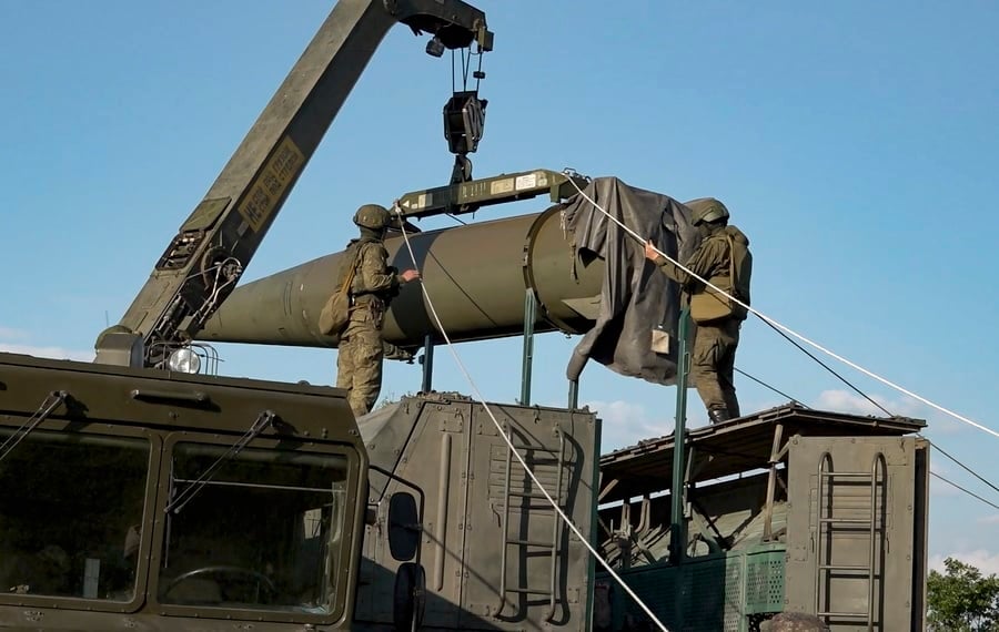

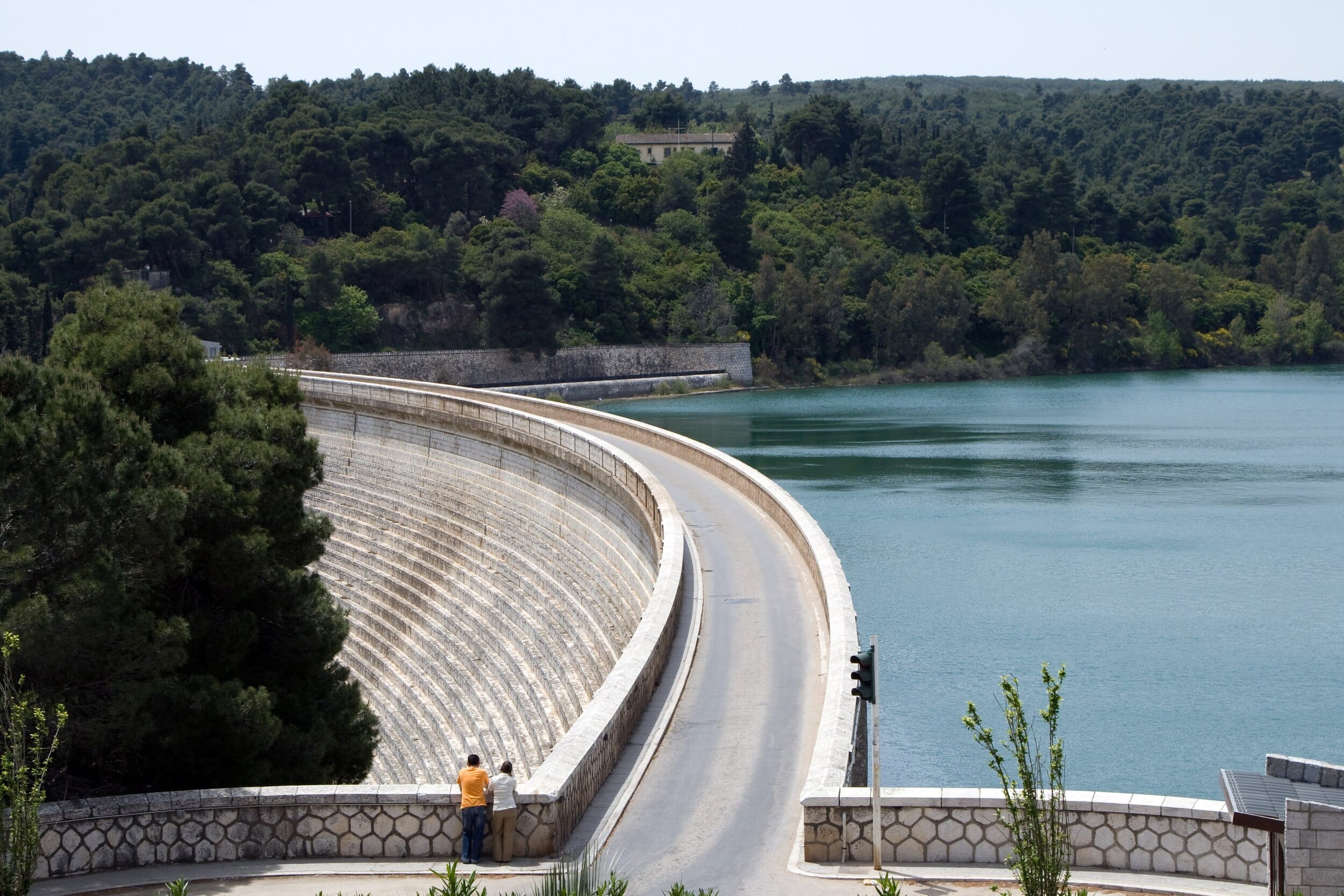

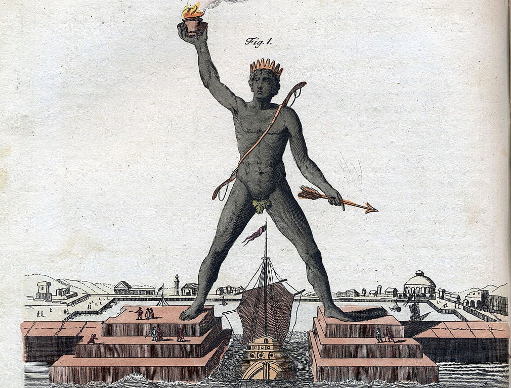
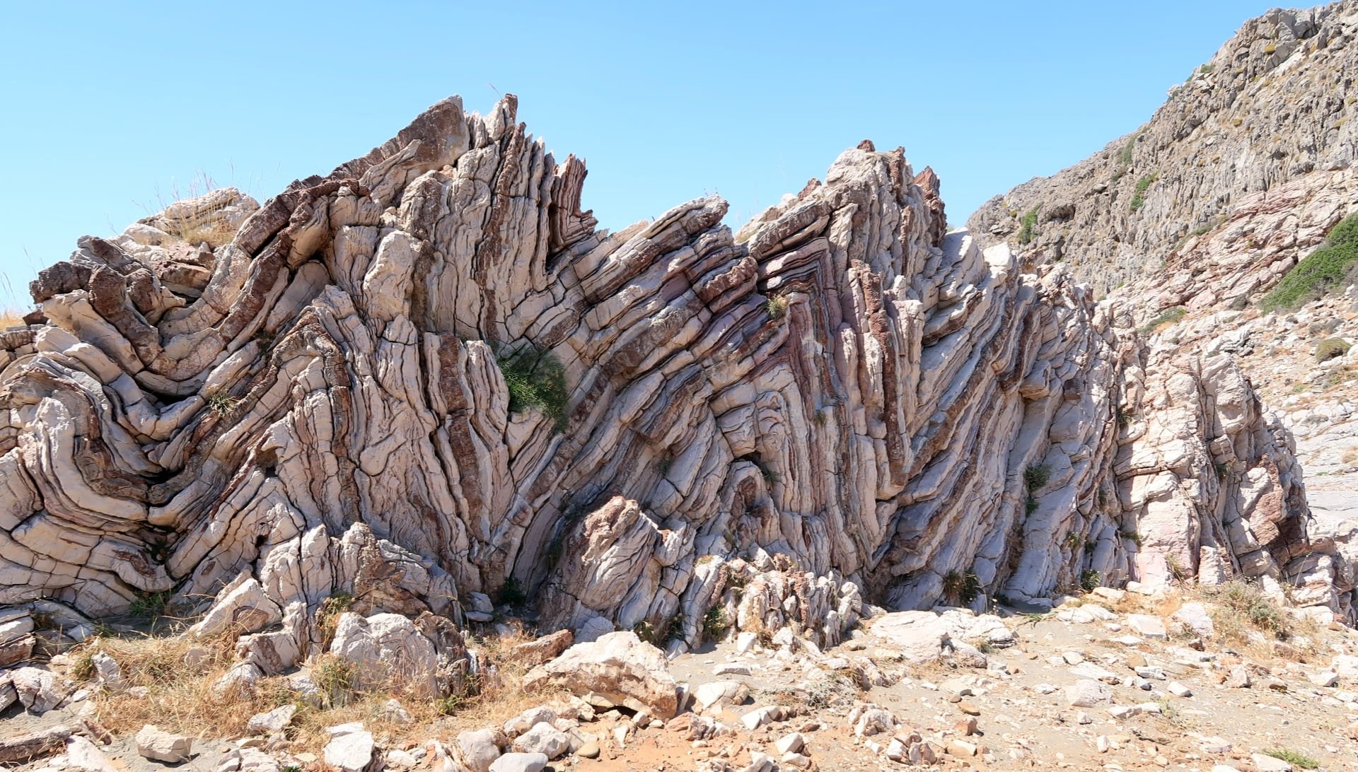
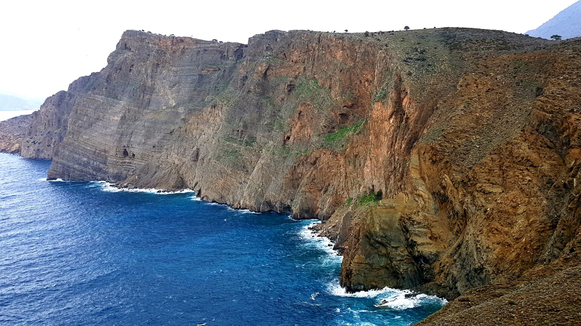
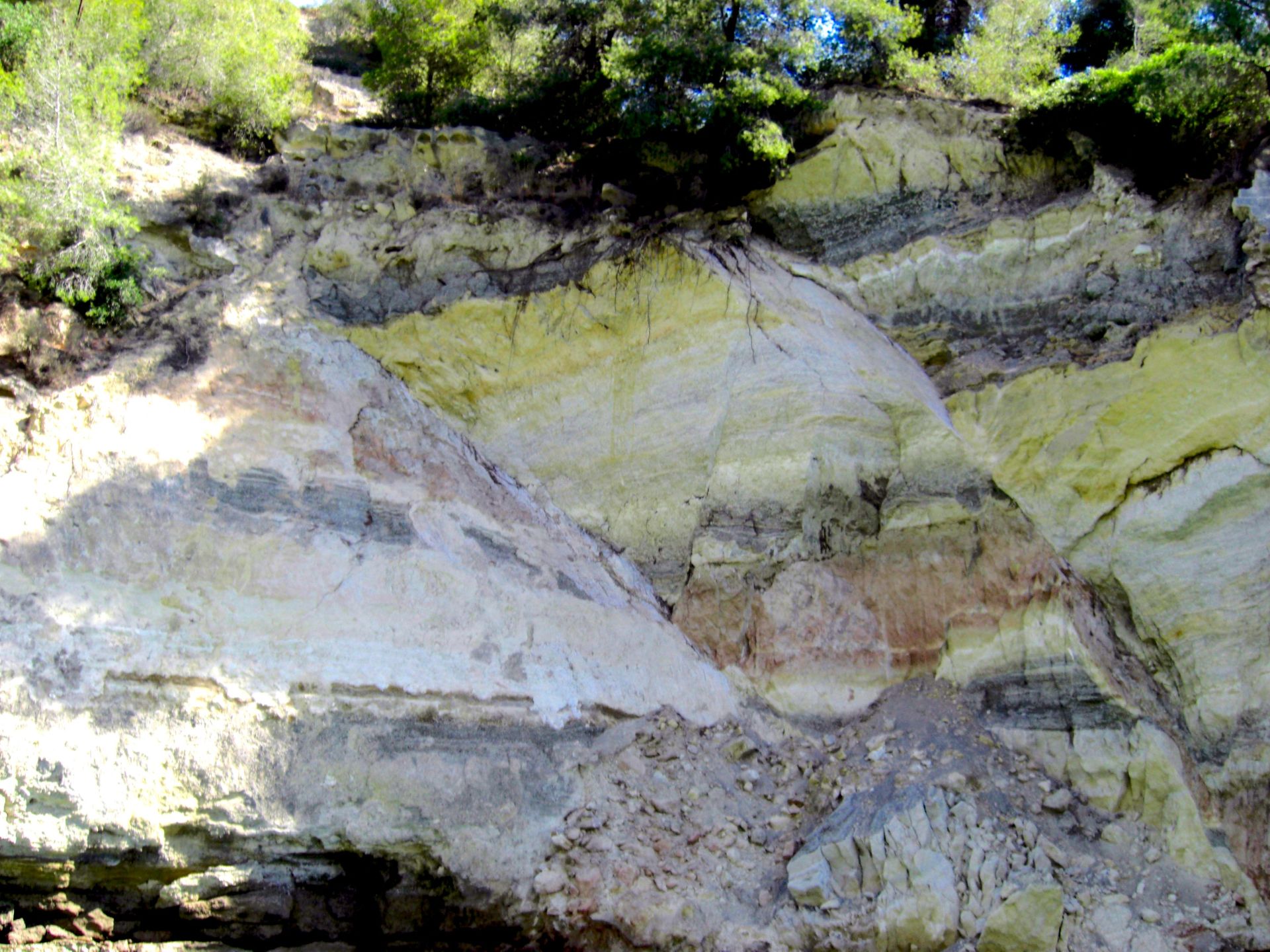


 BREAKING: A bus has been set on fire in Belfast amid protests over the attempted beheading of a man


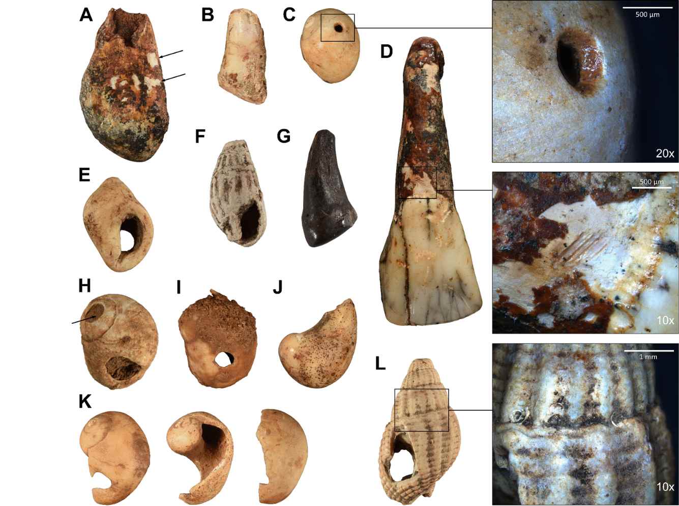
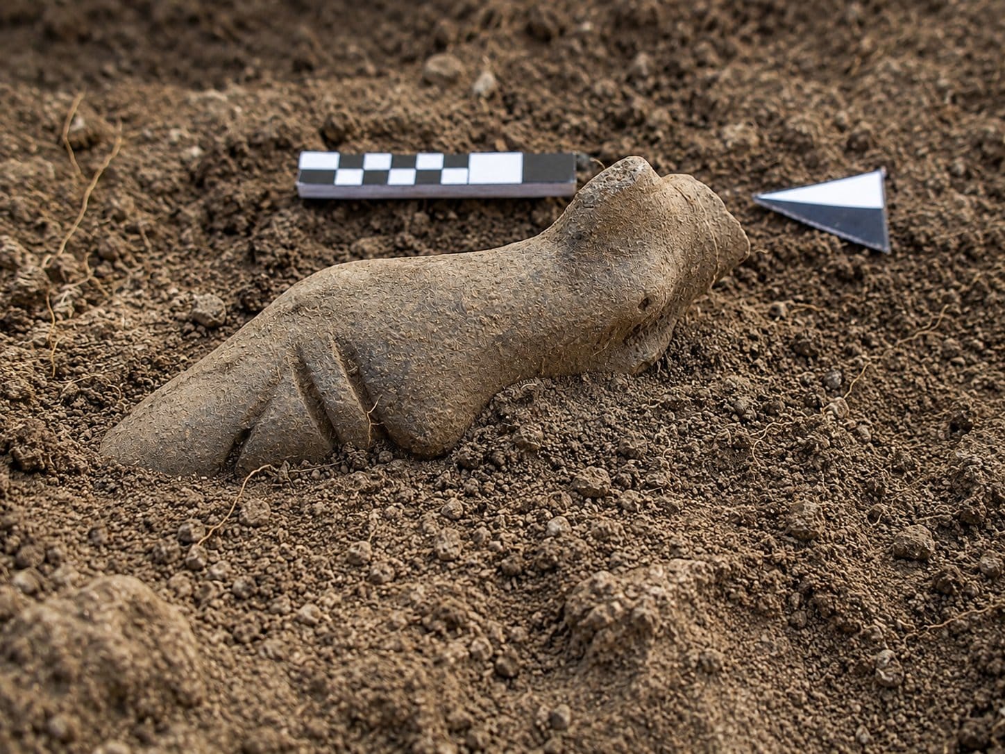


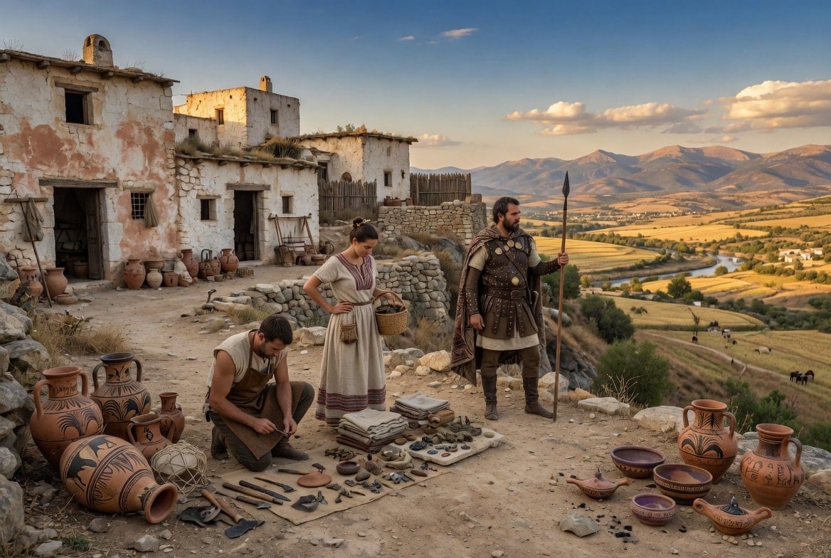
_02.jpg)