Reading view

The Breathtaking Ancient Greek Ruins Found in Italy

Temple of Concordia
Temple of Concordia – Agrigento, Italy. Credit: Public Domain

When you think about Italy and ruins, your mind’s eye automatically brings up scenes of the Roman Forum and the Colosseum. However, Italy is home to countless ruins which are actually ancient Greek—many of which remain in stellar condition.

The country’s mainland, as well as the island of Sicily, are dotted with Greek ruins—some of which are integrated into modern-day cities and are still even used to host events! Others can be found in isolated locations well off the beaten path.

Ancient Greek Ruins of Italy

As you travel through Italy, as you really should if you call yourself a well-traveled individual, be sure to say “Opa!” as often as you say “Mamma mia!” The following are just some of the truly jaw-dropping ancient Greek ruins which are scattered throughout the Italian countryside.
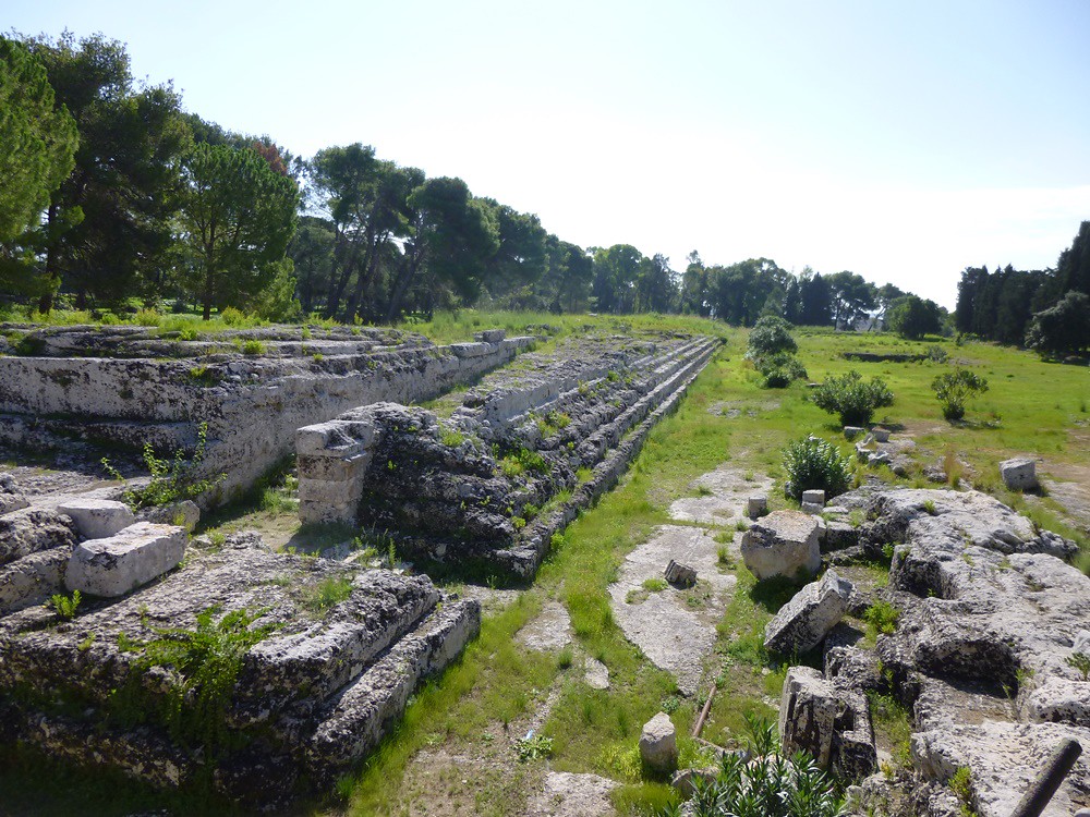
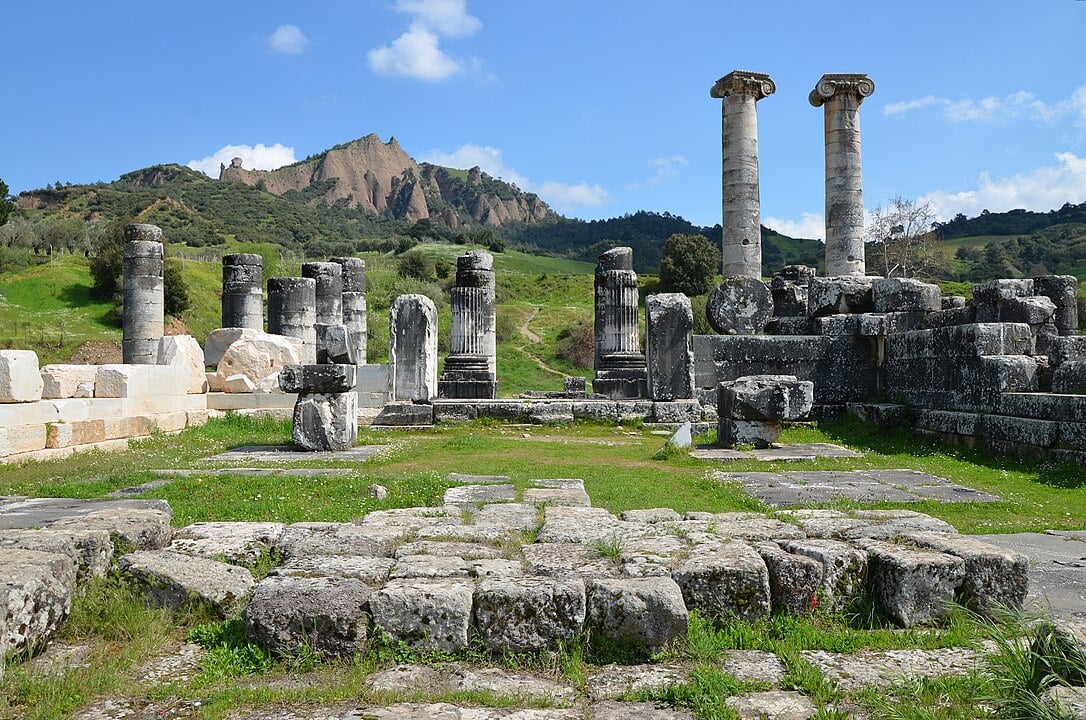
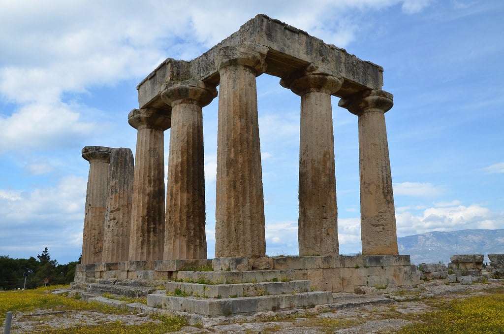
Paestum

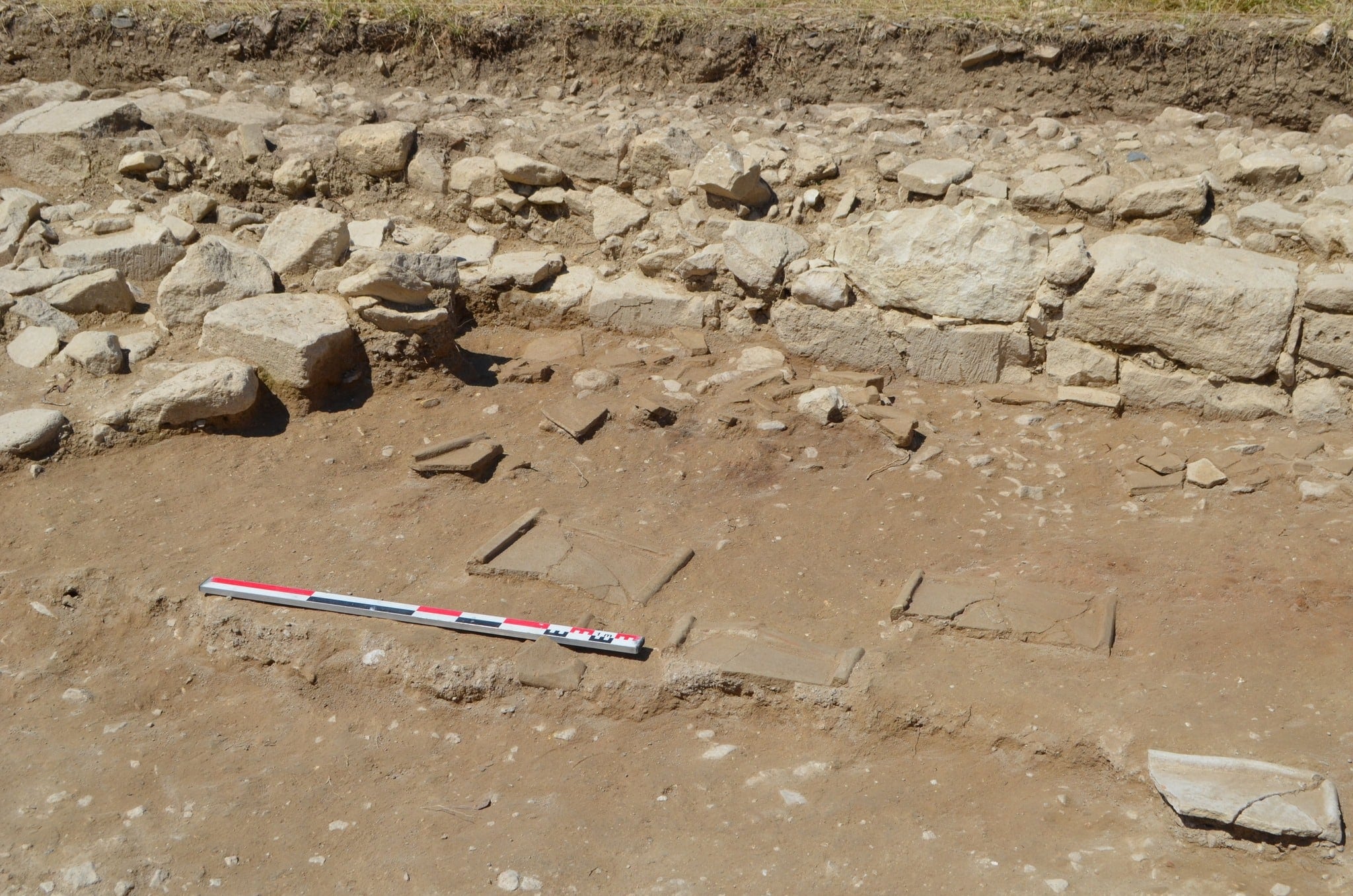
Located in southern Italy along the coast of the Tyrrhenian Sea in what was then called “Greater Greece” or Magna Graecia, this was a major Greek city in ancient times. The ruins date back to 600 to 450 B.C. and are some of the best-preserved Greek temples in the world!

Paestum
Temple of Hera, Paestum (Poseidonia) Italy. Credit: Norbert Nagel/CC BY-SA 3.0

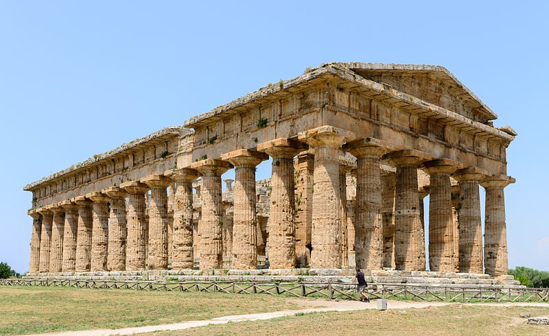
The three famous ancient Greek temples at this site are of the Doric type, and the ancient city walls and amphitheater are mostly intact. The bottom section of walls from many other structures are completely intact.

It is an amazing experience to be able to walk along the ancient stone-paved roads and view the buildings along the roadsides just as the ancients did. The site is open to the public, and there is a modern national museum on-site for you to check out as well.

Another plus is that this archeological site is well off the beaten path and is seldom crowded with visitors!
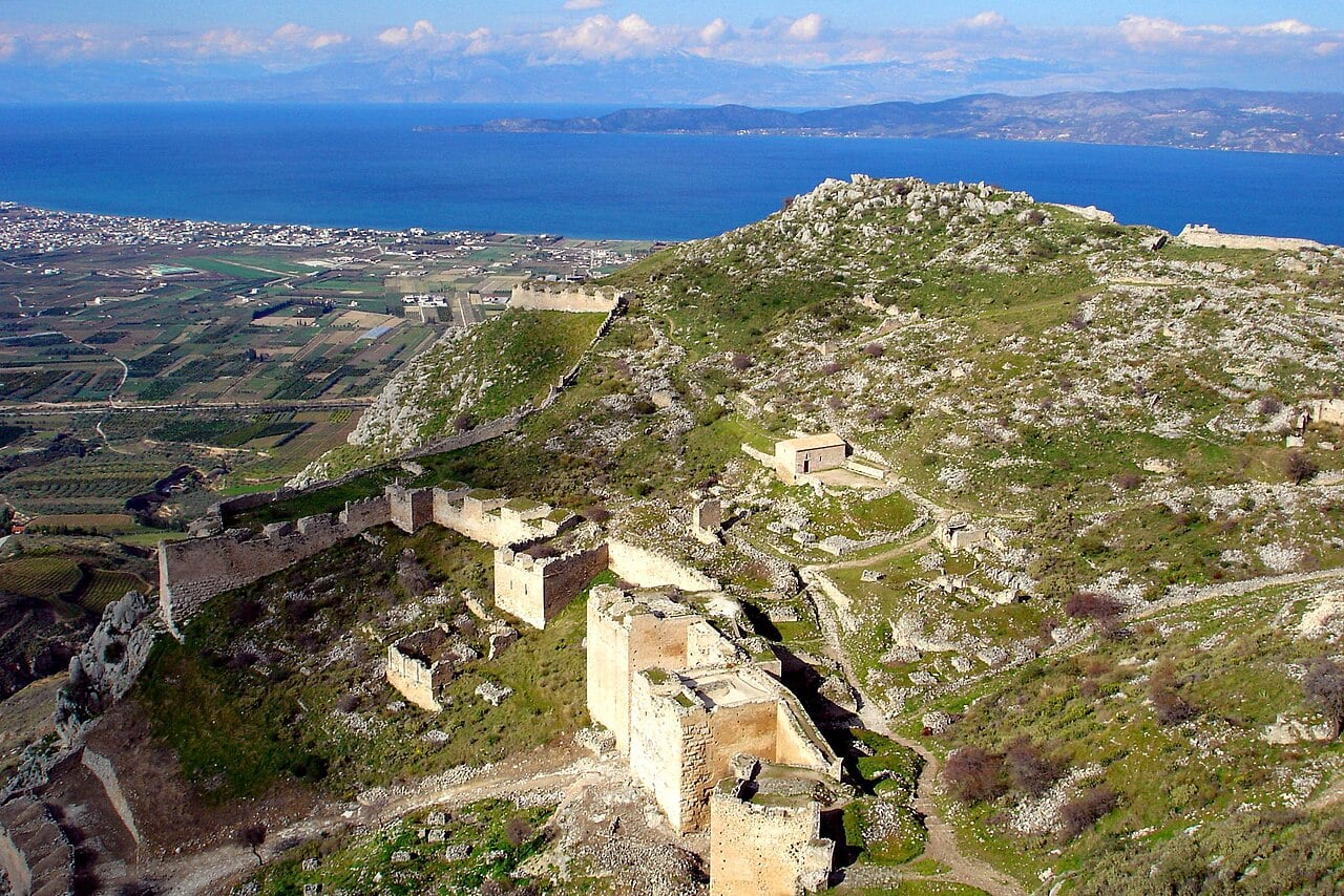
Locri Epizefiri

Also on the mainland of Italy, in Reggio di Calabria, you will come across the ancient ruins at Locri. The ancient city has been mostly taken over by the encroachment of the nearby towns.

Locri Epizefiri,
Locri Epizefiri, greek theater. Credit: Sandro Baldi/CC-BY-SA-4.0

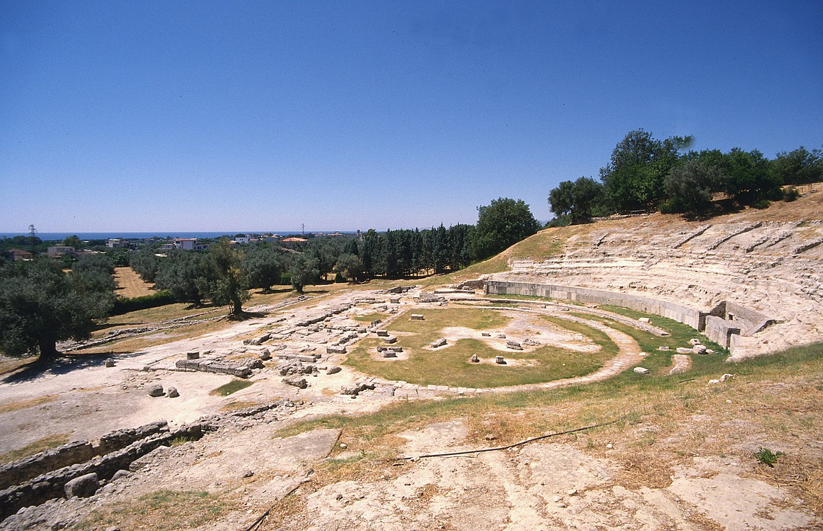
However, the area is very much worth a visit because the atmosphere quiets as you pass through shady olive groves and meander along the overgrown pathways. It is here where you will inevitably, and literally, stumble across a treasure of ancient ruins.

Greek temples, amphitheaters, and the well-known Sanctuary of Persephone grace the Locri area. The magical experience is truly something you shouldn’t miss out on.

On the island of Sicily, some truly remarkable ruins are yours to explore, starting with the still-used ancient Greek Theater of Taormina!

The Ancient Greek Theater of Taormina

With the beautiful Mediterranean sea lapping at the shores below and the active volcano of Etna looming over the city, Taormina is an upscale destination, featuring cultural events, museums, and priceless antiquities—right in the middle of a bustling city!

The ancient theatre of Taormina ruins
The ancient theatre of Taormina. Credit: Public Domain

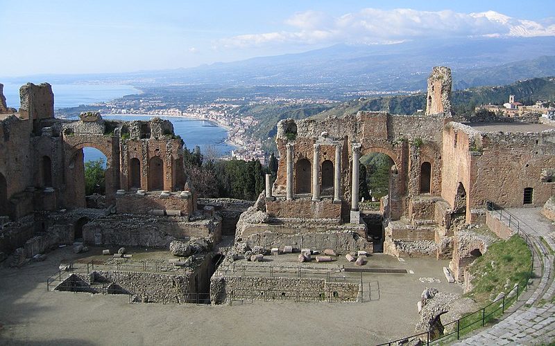
Here you will find an ancient Greek amphitheater with exquisite views of both the volcano and the sea. While there, you might even be lucky enough to see a show at the ancient theater. It was originally built in 300’s B.C. and subsequently rebuilt by the Romans in the second century B.C.

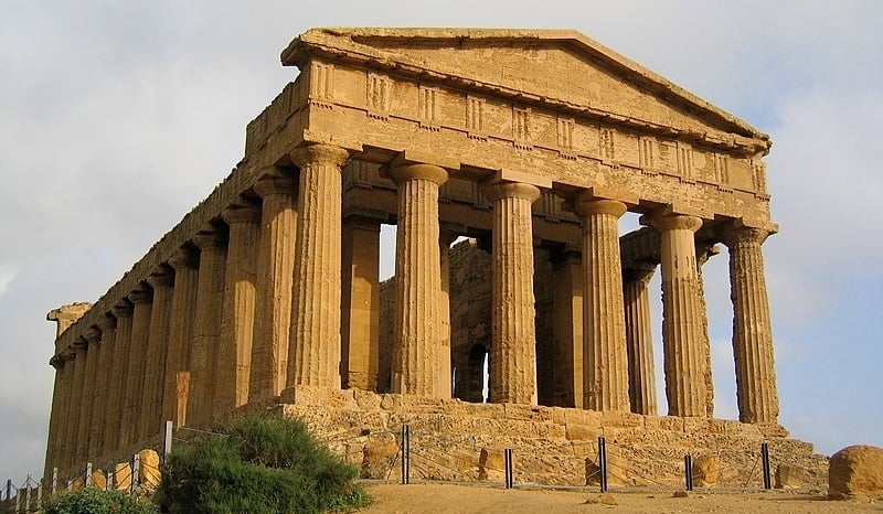
Valle dei Templi in Agrigento

In Argrigento, you will be treated to refreshing views of expansive fields and woodlands—as well as one of the most pristine ancient Greek ruins in existence in the Valle dei Templi (the Valley of Temples).

Agrigento, ruins
Agrigento, valle dei templi. Credit: Jesper2cv/CC BY-NC-ND 2.0

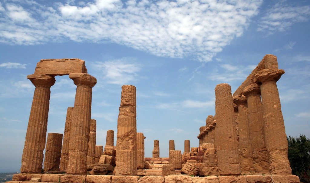
Many of the temples and ruins here are not fenced off, so travelers may walk inside and be transported back to the fifth century B.C., when the Greeks first built the ancient city of Akragas. One of the most well-preserved Greek temples in the world, the Temple of Concord, is in this valley.

Segesta Archaeological Site

Segesta is located only 70 kilometers (43 miles) southwest of Palermo. Fortunate travelers here can visit what is perhaps the second most well-preserved temple in the world after those in the Valle dei Templi. Segesta also boasts a beautiful amphitheater, situated atop Mount Barbaro, which is also in pristine condition.

Segesta ruins
The Doric temple of Segesta, Italy Credit: Anna & Michal/CC BY-SA 2.0

The temple dates back to the fifth century B.C. and has typical Doric architecture. Each summer the ancient amphitheater hosts a series of classical Greek dramas performed in Italian. If you’re lucky enough to visit during the summertime, be sure to catch a show.

Ancient Greek Colony in Siracusa

A favorite for all are the ancient ruins at Siracusa (Syracuse), where the ancient Greek colony dates back to the 5th century B.C. This area boasts a Greek theater and the Temple of Apollo, which dates back to the 6th century. Siracusa also has the ruins of the famous Altar of Hieron II—the largest altar from ancient Greece!

Ancient ruins at Siracusa
Ancient ruins at Siracusa Il Turista Informato/CC BY-NC 2.0

Located on the southeastern coast of Sicily and founded by ancient Greeks from Corinth, the city of Siracusa was once one of the most powerful city-states of ancient times. It was once described by the Roman orator Cicero as “the greatest Greek city, and the most beautiful of them all.”

Siracusa is so rich in historical treasures that it is listed as a UNESCO World Heritage Site.

Of course, there are many other Greek ruins that you will come across in your travels through Italy and Sicily, and we have merely scratched the surface in highlighting some of the more popular and well-preserved sites.

Be sure to work a little bit of Greek history into your itinerary on your visit to Italia!

  •  

Israeli attack on Tyre in Lebanon kills eight as evacuation ordered for Christian quarter

People flee historic district of ancient city after airstrikes hit residential areas and damage archaeological sites

Israel has bombed the city of Tyre, killing eight and injuring at least 32 people, and struck dozens of other villages in south Lebanon as it issued forced evacuation orders for the historic Christian quarter of the ancient city for the first time.

Israel struck the al-Masaken neighbourhood without warning on Tuesday morning, sending smoke plumes high above the city’s buildings and igniting fires. Further airstrikes were carried out across the city and a series of bombings hit Abbasieh, a village north of Tyre.

Continue reading...

© Photograph: Kawant Haju/AFP/Getty Images

© Photograph: Kawant Haju/AFP/Getty Images

© Photograph: Kawant Haju/AFP/Getty Images

  •  

Long-Assumed Roman Helmet Hoard Off Spain Turns Out to Be Medieval

Details of the overlapping helmets
Details of the overlapping helmets. Credit: Manuel Frallicciardi / CC BY 4.0

Researchers have confirmed that an underwater helmet hoard off Spain’s eastern coast near Benicarló is medieval rather than Ancient Roman as long assumed. The finding places the collection in the late 14th to early 15th century, during a period of intense maritime conflict along the Valencian coast.

The study was led by Manuel Frallicciardi, a doctoral student jointly supervised by the University of Alicante and the University of Salerno, and published in the journal Antiquity. It marks the first time radiocarbon dating has been applied to iron helmets from an underwater site.

Divers recovered the helmets in 1990 from Piedras de la Barbada, a submerged site about six meters (20 feet) deep near Benicarló in eastern Spain. At least forty-three helmets were identified. Split between two institutions, most of the helmets are stored at the Museu de Belles Arts de Castelló, while two conserved ones are on display at the Museo de la Ciudad de Benicarló.

Because the site had also yielded Roman-era artifacts, including ancient amphorae and Punic War-era bronze helmets, early researchers assumed the iron helmets belonged to the same ancient period.

Fabric linings within helmets unlocked dating mystery

Frallicciardi and his team found organic evidence trapped inside the helmets. Marine sediment had sealed fabric linings in place, protecting them from full decay. The fibers, identified as plant-based bast material in a plain tabby weave, were sent to the Beta Analytic laboratory in Miami and the Curt-Engelhorn-Zentrum Archaeometrie in Mannheim, Germany.

Medieval helmets from different viewpoints
Medieval helmets from different viewpoints. Credit: Manuel Frallicciardi / CC BY 4.0

Four of the five radiocarbon results clustered between the last quarter of the 14th century and the early 15th century. One sample returned a date roughly 150 years later than the rest. Researchers linked this to post-depositional contamination. That helmet sat in a more exposed position, and microscopic analysis showed its fibers were more degraded, conditions that could allow younger carbon to infiltrate the sample.

Spain’s underwater helmet hoard links to medieval piracy era

The helmets fall into two types. Most have rounded skull caps with a central ridge, resembling simplified infantry helmets documented in medieval sources, including the Holkham Bible from around 1330 to 1340 and a fresco painted by Jacopo Uccello around 1378. One helmet has a six-panel faceted construction comparable to a kettle hat depicted in a 1437 altarpiece by Hans Multscher.

Frallicciardi noted the helmets predate the era when large Italian and German workshops standardized European armor production. Their simple construction points to smaller regional workshops supplying local infantry markets. The historical context strengthens that picture. From the 1370s onward, Islamic piracy along the Valencian coast intensified sharply, peaking in the final decades of the 14th century.

Communities responded by building coastal towers, fortifying settlements, and mobilizing local militias. Researchers believe the helmets were most likely lost at sea during this period of sustained maritime insecurity.

  •  

Denmark’s 2,500-Year-Old Hole Belts Puzzle Archaeologists

AI view of a reconstructed Iron Age hole belt
AI view of a reconstructed Iron Age hole belt. Credit: Greek Reporter Archive

Archaeologists in Denmark are recreating a puzzling Iron Age feature to understand better its purpose more than 2,500 years after it was built. Known as hulbælter in Iron Age, or “hole belts,” the structures consist of long rows of shallow pits that stretch across the landscape.

Dating to around 500–300 B.C., some extend for hundreds of meters, while others run for several kilometers. Researchers have identified nearly 50 examples across Denmark, particularly in central and western Jutland. Despite decades of study, archaeologists still do not know exactly why the pits were dug.

Hole belts remain one of Denmark’s oldest mysteries

The pits are not graves, ordinary postholes, or waste pits. Instead, they form organized belts three to six meters (9.8 to 19.6 feet) wide, with individual holes typically measuring only 30 to 40 centimeters (0.98 to 1.3 feet) deep.

Similar features have been reported in Sweden and the Netherlands, but they are far more common in Denmark. Their unusual layout suggests they were built for a specific purpose rather than as isolated features.

To investigate, researchers at the Saxo Institute at the University of Copenhagen have launched a large-scale experimental archaeology project.

Researchers rebuild an Iron Age landscape

Led by associate professor Henriette Lyngstrøm, the project brings together 30 archaeology students at Sagnlandet Lejre, an open-air research center and reconstructed Iron Age village.

The team is rebuilding a hole belt from scratch using reconstructed tools and ancient techniques. Researchers are measuring the time, effort, and coordination needed to create the features. The goal is to move beyond theory and test how the belts may have functioned in everyday life.

Digging reveals the scale of Iron Age labor

One part of the project focuses on reconstructed wooden spades based on Iron Age finds. Archaeologists once thought some of these tools may have been paddles. However, traces of soil, stones, and wear patterns suggest they were used for digging.

Archaeologists in Denmark are recreating mysterious 2,500-year-old Iron Age "hole belts" to uncover their purpose.

Were they defensive barriers, storage pits, boundary markers, or something else entirely?#Archaeology #IronAge #Denmark #AncientHistory pic.twitter.com/o3ZrDywejZ

— Tom Marvolo Riddle (@tom_riddle2025) June 8, 2026

Tests showed that wooden spades could create the pits, but the work was slow and physically demanding. The tools also required frequent sharpening.

The findings indicate that constructing long hole belts would have required planning, organization, and coordinated labor. Researchers say such projects likely involved leadership and cooperation within Iron Age communities.

Food storage theory gets a real-world test

Researchers also examined whether some pits could have been used for storage. Graduate student Angelyn Sørensen placed a chicken inside a ceramic jar buried in a reconstructed pit. On a day when air temperatures reached about 20 degrees Celsius, the meat warmed only slightly, rising from around 10 to 12 degrees.

The results suggest that covered pits could help moderate temperatures, although the experiment does not prove a storage function.

Experiments test the defensive barrier theory

The strongest results came from tests of the defensive theory. Earlier studies showed that sheep and cattle could cross similar pit zones without difficulty. However, when researchers staged mock combat exercises, the pits made movement more difficult for attackers.

Participants struggled to maintain balance, move quickly, and fight while crossing the uneven terrain.

Researchers stress that no single explanation has been confirmed. Still, the experiments show that the hole belts were carefully planned features that required labor, organization, and a clear purpose. Their exact role remains uncertain, but the project is bringing archaeologists closer to understanding one of Denmark’s most enduring Iron Age mysteries.

  •  

2,200-Year-Old Roman Basilica Found Near Rome Reveals Rare Painted Female Head

Tusculum, forum. Areas 1 and 2
Tusculum, forum. Areas 1 and 2. Credit: Francesco De Stefano / CC BY 4.0

Archaeologists have uncovered the remains of a Roman basilica at Tusculum, an ancient city located about 30 kilometers (18.6 miles) from Rome, dating it back to the 2nd century B.C.

The discovery places the structure among the oldest known examples of Roman public basilica architecture, adding a significant piece to the puzzle of how Rome shaped its cities during the Republican era.

Researchers from the Spanish School of History and Archaeology in Rome, known as EEHAR-CSIC, made the find in the southern part of Tusculum’s forum. The forum served as the political and social heart of the city.

The basilica had remained hidden beneath later imperial-era structures for centuries. Antonio Pizzo, who leads the project, said the building is one of the earliest known examples of its type and joins a small, well-documented group of Republican basilicas.

Inside Tusculum’s ancient Roman basilica and its rare design

The structure measured 17.7 by 25.2 meters (58 by 82.7 feet). Its monumental facade featured a series of arches resting on nine flat pilasters, an architectural arrangement known as the “Theatermotiv.”

Pizzo noted that if researchers confirm this interpretation, it would mark the first time this design appears in Roman architecture. Until now, this style had only been identified in later, exceptional buildings such as the Tabularium in Rome.

Female protome
Female protome. Credit: Francesco De Stefano / CC BY 4.0

Among the most striking finds was a polychrome stucco capital discovered inside one of the building’s rooms. It depicts a female head rising from a cup of acanthus leaves, flanked by Ionic scrolls and floral motifs painted in white, red, and green.

The timing of the basilica’s construction aligns with the rise of powerful families from Tusculum, including the Mamilia, Fulvia, and Porcia clans.

The Porcia family produced Marcus Porcius Cato, famous for his repeated calls to destroy Carthage before the Third Punic War. Pizzo said these families drove a wave of monumental construction that went hand in hand with Rome’s growing power across the Mediterranean.

Powerful families and a Roman general add historical depth

Researchers also linked the site to Marcus Fulvius Nobilior, one of the most influential figures of the 2nd century B.C.

After defeating the Aetolian League in Greece, he returned to Rome with Hellenistic art and treasures. An inscription found at Tusculum confirms that some of that spoil went to his hometown.

Francesco De Stefano, co-author of the study published in the Journal of Roman Archaeology, said the discovery contributes valuable knowledge about the origins of this building type and key innovations in Roman public architecture.

The EEHAR-CSIC team has worked at Tusculum continuously since 1994, excavating its forum, theater, and baths. In 2023, they also uncovered a well-preserved marble female statue, with further details expected soon.

  •  

New Study Links Göbekli Tepe Symbols to Ancient Trypillia Rituals

The Vulture Stone, featuring carved symbols at Göbekli Tepe
The Vulture Stone, featuring carved symbols at Göbekli Tepe. Credit: Sue Fleckney / Wikimedia Commons / CC BY-SA 2.0

A new study suggests that the carved symbols at Göbekli Tepe may have been part of a sophisticated belief system that connected timekeeping, sacred space, death, and the heavens.

Published in the International Journal of Culture and History, the research by Oleksandr Zavalii compares imagery from the famous Vulture Stone at Göbekli Tepe with ritual symbols from the later Trypillia culture of present-day Ukraine, Moldova, and Romania.

The study argues that both societies may have used similar symbolic frameworks to understand the cosmos and organize religious life.

Göbekli Tepe, in southeastern Türkiye, dates to roughly 9600-8200 BCE and is considered one of the world’s earliest monumental ritual centers. Zavalii focuses on several of its carved pillars, particularly Stele 43, known as the Vulture Stone.

Researchers interpret the Vulture Stone as a cosmological map

The monument features birds, snakes, a scorpion, geometric symbols, and a headless human figure. Zavalii argues that the arrangement was deliberate. The upper portion contains bird figures, circles, and abstract signs that may represent celestial forces.

The lower section contains animals and human imagery associated with the earthly world, death, or the underworld. Rather than viewing the carvings as isolated images, the study interprets them as parts of a broader symbolic language.

The Vulture Stone has attracted astronomical interpretations for years. In 2017, researchers Martin Sweatman and Dimitrios Tsikritsis proposed that some animal figures represented constellations and may have recorded events linked to the debated Younger Dryas impact hypothesis.

Did the builders of Göbekli Tepe share cosmological ideas with ancient farmers?

A new study compares the site's famous Vulture Stone with Trypillia ritual symbolism and suggests both cultures may have used same concepts to understand time, sacred space, death and the heavens. pic.twitter.com/hO1lHtUvYu

— Tom Marvolo Riddle (@tom_riddle2025) June 8, 2026

A later study by Sweatman suggested that V-shaped marks on the pillar could represent a lunisolar calendar. However, these interpretations remain controversial.

Researchers associated with the German Archaeological Institute have argued that repeated rebuilding and possible roofing of the structures complicate claims that the site functioned as an open-air observatory.

Numerical patterns may reflect concepts of sacred time

According to Zavalii, Stele 43 contains eleven rectangular symbols, while some circular enclosures at Göbekli Tepe include eleven T-shaped pillars. The repeated appearance of the number may have marked divisions of the year or important intervals between solar events.

Stele 33 provides additional evidence for this interpretation. The pillar contains snake-like figures, animals, and abstract motifs. Zavalii highlights the recurring numbers two, three, eleven, and thirteen, suggesting they may have been associated with concepts such as duality, solar cycles, and lunar rhythms.

In this reading, thirteen snake heads could symbolize the lunar year, while eleven may relate to the organization of solar time. Rather than functioning as a precise calendar, the symbols may have formed part of a sacred system used to represent the passage of time.

Trypillia comparison reveals shared symbolic themes

The study’s most distinctive contribution is its comparison with the Trypillia culture, which flourished thousands of years later in Eastern Europe.

Zavalii points to similarities between Göbekli Tepe’s symbols and Trypillian ritual objects, temple layouts, and ceramic designs. Particular attention is given to the Nebelivka Temple and distinctive “binocular-shaped” ritual artifacts.

The study suggests these forms, along with circular and crescent motifs, may have expressed ideas about duality, seasonal cycles, and sacred time.

The research does not claim a direct cultural connection between the two societies. Instead, it proposes that early farming communities may have developed comparable symbolic solutions for understanding the relationship between the sky, ritual practice, and community life.

Debate over Göbekli Tepe’s meaning continues

Other interpretations of Göbekli Tepe remain influential. Archaeologist Klaus Schmidt and later researchers emphasized the site’s role as a ritual gathering place linked to ancestor veneration and communal ceremonies.

Additional studies have connected the site’s headless figures, vulture imagery, and human remains to funerary practices and beliefs about death and transformation. Meanwhile, archaeologist Giulio Magli proposed that some enclosures may have been aligned with the appearance of Sirius in the night sky.

Together, these theories highlight the complexity of Göbekli Tepe. Zavalii’s study adds a new perspective by suggesting that the site’s carvings formed part of a larger symbolic system in which architecture, ritual, memory, and celestial cycles were closely intertwined.

  •  

How Ancient Greek Acropolises Went From Civic Pride to Symbols of Tyranny and Oppression

Acropolis of Athens in Greece at night
Acropolis of Athens in Greece at night. Credit: Giles Laurent / Wikimedia Commons / CC BY-SA 4.0

The ancient Greek Acropolises meant very different things to different people across history. A new study finds its symbolic meaning shifted dramatically over centuries, starting as a marker of civic pride and freedom before becoming firmly associated with tyranny and oppression.

Robin Rönnlund, an archaeologist at the University of Gothenburg in Sweden, published the study in the Annual of the British School at Athens. He examined ancient texts from Homer through the second century A.D. and traced how writers, philosophers, and inscription makers actually understood the word “acropolis” across roughly 1,000 years.

The research directly challenges a widely accepted scholarly narrative. For decades, historians described acropolises as prehistoric royal strongholds that were later abandoned and converted into either religious sanctuaries or civilian refuges during attacks.

Scholars built a false narrative around misread Aristotle

Rönnlund traces this narrative back to a misreading of a passage in Aristotle’s Politics, in which Aristotle theorized that acropolises suited oligarchies and monarchies.

Past scholars interpreted this theoretical statement as a historical sequence rather than a practical observation about fortifications, and the misreading quietly shaped academic thinking for generations.

Remains of the Temple of Artemis with the Acropolis, Sardis
Remains of the Temple of Artemis with the Acropolis. Credit: Carole Raddato / Wikimedia Commons / CC BY-SA 2.0

The word itself is also commonly misunderstood. Rönnlund explains “acropolis” does not mean “upper city,” as dictionaries suggest. It more precisely means “the farthest polis” or “the polis on the edge,” and it first appeared in the Odyssey in reference to Troy.

In early Greek poetry, the ancient Greek acropolis carried an unmistakably positive meaning. Simonides described the Acropolis as a symbol of Greek resistance to Persian invaders.

Ancient Greek Acropolis once stood for freedom and pride

Sparta was celebrated as the “acropolis of Greece” in the famous Lysander monument at Delphi. Philosophers extended the metaphor further. Plato called the head the “acropolis of the soul.”

Diocles of Karystos described the mind as a sacred statue placed on the acropolis of the body. These uses reflected strength, protection, and honor.

Acrocorinth, looking north towards the Gulf of Corinth
Acrocorinth, looking north towards the Gulf of Corinth. Credit: Vancouverquadra / Wikimedia Commons / Public Domain

The meaning turned darker as foreign military occupation became widespread. Ancient sources contain 66 passages linking tyrants to acropolises. Plutarch recorded a warning that Caesar should not be established as “tyrant in the acropolis.”

Macedonian forces turned a civic symbol into oppression

After 322 B.C., Macedonian forces systematically garrisoned acropolises across Greece to keep conquered cities under control. Both Demosthenes and Isocrates described how garrisoned acropolises kept entire regions in submission.

Civilian populations almost never used acropolises as refuges, contrary to popular assumption. The sites lacked sufficient water and supplies for prolonged occupation, and literary sources confirm people typically fled to the walled city below or into the countryside during attacks.

Rönnlund reviewed 133 individual acropolises mentioned in ancient sources and calls for future research combining archaeology, epigraphy, and field surveys to properly reconstruct how these sites functioned in ancient Greek life.

  •  

England’s Cerne Abbas Giant Fades Under Changing Weather Conditions

Cerne Abbas giant
Cerne Abbas giant. Credit: richie rocket. CC BY-2.0.

For more than 1,000 years, the Cerne Abbas Giant has stood on a hillside in Dorset, England, surviving wars, epidemics, and centuries of social change. Now, conservationists say increasingly unpredictable weather is threatening the famous chalk figure and forcing an earlier-than-usual restoration effort.

The 55-meter-tall (180-foot) giant, carved into a hillside above the village of Cerne Abbas, is one of Britain’s most recognizable landmarks. The figure depicts a naked man carrying a large club. For generations, residents helped maintain its bright white appearance by filling its outline with fresh chalk.

Today, the site is managed by the National Trust, which has traditionally re-chalked the giant about once every decade. However, conservation teams say changing weather conditions are making that increasingly difficult.

Weather speeds up restoration work

Around 300 staff members and volunteers are taking part in the latest restoration project. The effort involves carrying nearly 17 tons of fresh chalk up the steep hillside and packing it into the giant’s trenches by hand.

Workers first remove old and discolored material before mixing fresh chalk with water to create a paste. The new chalk is then pressed into the outline, helping restore the figure’s distinctive appearance.

The need for faster restoration became clear in 2019 when heavy autumn rainfall washed away much of the newly applied chalk shortly after conservation work had been completed.

England's famous Cerne Abbas Giant has survived for more than 1,000 years. Now, heavier rainfall, algae growth and erosion are forcing conservationists to restore the massive chalk figure earlier than planned. pic.twitter.com/0ShiLZzOYt

— Tom Marvolo Riddle (@tom_riddle2025) June 8, 2026

Conservationists also have concerns about algae growth. Mild, damp winters and warmer summers can create conditions that allow algae to spread across the chalk surface, causing the giant’s bright white outline to appear green and faded.

“In recent years, we’ve noticed algae growth starting to dull the giant’s bright white outline,” National Trust ranger Luke Dawson said.

Dawson cautioned against directly linking the changes to climate trends at a single site. “It’s one of these things we cannot really prove,” he told BBC News. “It is more just observation of what we are seeing up there.”

Researchers continue to debate the Giant’s origins

The Giant’s origins remain one of England’s enduring archaeological mysteries. Over the years, researchers suggested it could represent a prehistoric fertility symbol, the Roman hero Hercules, or even a satirical image of Oliver Cromwell.

Scientific dating has narrowed the timeline considerably. Researchers believe the figure was likely created between 700 and 1100 CE during the late Saxon period.

The Saxon dating has renewed interest in the Hercules theory. In a 2021 study published in the journal Speculum, researchers from the University of Oxford argued that the giant was originally carved as an image of Hercules.

They suggested it may have served as a landmark and gathering point for West Saxon forces during Viking attacks in southern England.

Conservation efforts expand beyond the hillside

The National Trust is also working to protect the landscape surrounding the Giant. A recent fundraising campaign helped secure 130 hectares of nearby grassland containing rare wildlife and important archaeological remains.

“The Giant was never meant to exist in isolation,” National Trust archaeologist Steve Timms said in a press release. He said protecting the surrounding landscape will help researchers better understand how people used and understood the area over thousands of years.

  •  

South African Cave May Hold Oldest Evidence of Human Fire Use

Neanderthals made first fire at a UK site
Ancient fire use. Credit: Steven Miller / Flickr / CC BY 2.0

Researchers studying a cave in South Africa have found evidence that could push the record of ancient fire use back hundreds of thousands of years.

The findings come from Wonderwerk Cave in South Africa’s Northern Cape Province, a site that has produced some of the oldest known evidence of human activity. The study was published in the journal PLOS One.

Researchers uncover evidence in a deeper cave layer

Previous excavations at Wonderwerk Cave revealed signs of fire use about one million years ago. Researchers based that conclusion on burnt animal bones, heat-altered stone tools, and burned sediments found in a layer known as Stratum 10.

In the new study, archaeologists examined an older layer called Stratum 11. There, they found small mammal bones that showed signs of exposure to heat.

To determine the age of the deposits, researchers analyzed cave sediments using magnetostratigraphy and cosmogenic burial dating. Together, the two methods indicated that the remains were deposited between 1.07 million and 1.79 million years ago.

If confirmed, the discovery could represent the oldest evidence yet found for the use of fire by early humans.

New technique helps identify burned bones

Researchers used a method known as bone luminescence to confirm that the fossils had been exposed to fire.

The technique involves shining high-energy blue light onto fossilized bones under a microscope. Burned bones respond by glowing bright red when viewed through a specialized filter. This allows scientists to detect evidence of heating that may not be visible through traditional examination methods.

Researchers at South Africa's Wonderwerk Cave have uncovered burned animal bones dating between 1.07 and 1.79 million years ago. If confirmed, the discovery could represent the oldest known evidence of fire use by early humans.#Archaeology #HumanEvolution #Anthropology #Science pic.twitter.com/PJX3doqUVa

— Tom Marvolo Riddle (@tom_riddle2025) June 8, 2026

The analysis showed that several of the bones from Stratum 11 had been subjected to high temperatures.

Researchers also ruled out wildfires as the likely source of the burning. The fossils were discovered about 30 meters (98 feet) from the cave entrance, deep inside the cave, and beyond the reach of flames from natural fires outside.

Findings suggest repeated fire use

The study does not show that early humans could make fire whenever they wanted. It also does not provide evidence for routine cooking. Instead, the findings suggest that groups occupying the cave may have repeatedly carried fire into the site and managed it there.

Researchers said the pattern and distribution of burned bones in both Stratum 10 and Stratum 11 point to multiple combustion events rather than a single accidental fire.

Because evidence of ancient fire use is often difficult to distinguish from natural burning, the question of when humans first controlled fire remains one of archaeology’s most debated topics. The new findings add important evidence to that discussion and provide a deeper look into the behavior of some of humanity’s earliest ancestors.

  •  

Archaeologists Uncover Rare Medieval Game Board in Morocco

The gameboard in the hammam at Walīla, Morocco
The gameboard in the hammam at Walīla, Morocco. Credit: Tim Penn / CC BY 4.0

A stone game board carved inside a medieval bathhouse in Morocco could rewrite what historians know about board games in early Islamic North Africa.

The discovery, published in the journal Libyan Studies, pushes back evidence for a game still played today by several centuries and sheds new light on social life in one of the region’s earliest Islamic settlements.

Tim Penn of the University of Reading led the study examining a previously unpublished game board at Walila, the site of ancient Roman Volubilis in Morocco. The board was carved into a stone step leading into a cold plunge pool inside a bathhouse, or “hammam,” built in the late eighth or early ninth century.

The structure was abandoned by the tenth or eleventh century. That narrow window gives researchers a rare, secure date for the board, something that is extremely difficult to establish for carved game boards found at ancient sites.

Morocco bathhouse yields a precisely dated medieval game board

The bathhouse was part of a larger complex that researchers believe served as the residence of Idrīs I, the founder of the Idrisid dynasty and one of the earliest Islamic rulers in North Africa.

Idrīs I arrived at Walila in 788 after fleeing the Hijaz and was declared imam by a local Berber tribe. The complex included a domestic building, a reception hall, and a storage compound, all built in a courtyard style more common to the Levant than North Africa.

The game board itself measures roughly 34 by 9.5 centimeters (13.4 by 3.7 inches) and consists of three rows of at least 13 small, shallow holes carved into the stone.

The gameboard in the hammam found in Morocco
The gameboard in the hammam at Walīla (left), with mark-up showing position of holes (right). Credit: Tim Penn / CC BY 4.0

Researchers identified it as most likely used for “tab/sig,” a running-fight game in which two players move pieces across the board from opposite sides, trying to capture each other’s pieces. The game is still played in parts of North Africa, the Middle East, and Turkey today.

Tab identified as Walila’s ancient running-fight game

The identification matters because the first known written reference to tab appears in the work of Egyptian author Ibn Daniyāl, who died in 1310.

The Walila board predates that reference by roughly 400 to 500 years, suggesting the game has a far longer history in the region than texts alone would indicate.

Researchers also ruled out mancala, another widely played ancient game, because the Walila board’s holes are too shallow and too small to hold multiple playing pieces, which mancala requires. The odd number of holes per row also makes the mancala rules impractical.

Similar boards from the early Islamic period have been found in Arabia, the Middle East, and Portugal, but none had previously been confirmed anywhere in North Africa.

The broad distribution of these boards across the early Islamic world, and as far as Scandinavia, where a closely related game called “daldos” or “sahkku” was played, points to the game traveling through trade and cultural networks.

From Arabian trade routes to Scandinavian shores

At Walila, those connections to the east are well documented. Imported coins, glassware, and a wine jar from Egypt and the Levant were all recovered at the site.

The bathhouse itself uses a dry-heat system more closely linked to Levantine construction than to the Roman bathing tradition, further reinforcing ties to the Middle East. Researchers suggest the game may have arrived in Morocco with Idrīs I or members of his entourage.

The board sat at the center of the steps into the plunge pool, fully visible to anyone in the changing room or entering the water. Researchers noted that its prominent placement suggests gaming was openly accepted as part of the social experience of bathing.

Bone dice recovered from nearby buildings at the site further confirm that a range of games, including games of chance, were played at Walila during the early medieval period.

The study calls on archaeologists working across North Africa and the broader Mediterranean to document game boards more systematically, noting that carvings of this kind are routinely left out of excavation reports.

  •  

The Ring of Legendary King Minos: A Tale of Intrigue and Deception

Ring King Minos
Ring of Minos Heraklion. Credit: Wikipedia/Jebulon/Public domain

The story of the ring known as the “Ring of King Minos” sounds like a tale made in Hollywood. It is a mix of ancient Greek history, mythology, and a plot involving a poor boy, a cunning priest, an English archaeologist, and hidden treasure.

The story begins in 1928, when a boy, Michalis Papadakis (1918-1974), accidentally found a ring at the archaeological site of Knossos. The place of discovery alone meant that the ring certainly had a very long history attached to it probably even going back to the Minoan civilization.

Indeed, several decades later, the shiny, gold, seal ring proved to be 3,500 years old (1,500 to 1,400 BC), as archaeologists assured him, and his was the most significant discovery of Minoan Civilization.

The boy’s father, a destitute farmer named Emmanouil, for some unknown reason, hid the ring from his wife and, for another unknown reason, two years later, he handed it over to the village priest, Father Nikolaos Polakis. Yet, before giving it away, he carved a line on the ring with his knife in order to mark its originality.

Father Polakis initially presented it to English archaeologist Sir Arthur Evans with the intention of selling it. However, there was no deal struck between the two since the priest demanded an astronomical amount of money.

In 1933 or 1934, Father Polakis decided to take the ring to the Heraklion Museum. At the time, the distinguished archaeologists, Nikolaos Platon and Spyridon Marinatos, were on the staff of the institution. Platon decided that the ring was genuine while Marinatos believed the ring was a fake.

Since the two archaeologists could not come to an agreement, they decided it was best to return the ring to the priest.

Ring King Minos
The King Minos Ring at the Heraklion Archaeological Museum. Credit: Twitter/Bokeras

However, Platon kept a copy of the ring by casting it in plasticine. The cast was later located in Platon’s archive. Several years later, he manifested a new interest in the ring and returned to the priest to ask for it. Father Polakis told him that he had given it to his wife for safekeeping, but she had lost it.

Minos ring depicts three themes

Platon wrote a treatise on the ring saying that it depicts three themes: the Minoans’ rule of the seas (“thalassocracy”), tree worship (dendrolatry), and a goddess descending from heaven to earth and getting into a row boat.

There are other, more recent interpretations of the depictions of the ring including the worship of goddesses, such as Mother Dimitra, and offerings to the Great Mother Rhea and the Great Mother Artemis.

For some time, the ring remained lost. The only information about the ring came from the copies that had been made and a number of archaeological reports which were associated with those copies.

Many years later, when Father Polakis was in his final days, he felt great regret about the “disappearance” of the precious ring. He called Evangelia Papadakis, the wife of the farmer Emmanouil, and apologized for lying to her family. He admitted that he had actually sold the ring to Evans, the English archaeologist, for 100,000 drachmas back in 1938.
However, that was one last lie by the cunning priest. What he had actually sold to Evans was a fine replica of the ring.

Evans had returned to England with the belief that he had bought the actual ring, along with a copy, and donated both, along with other precious artifacts, to the Ashmolean Museum. Today, two replicas of the legendary ring continue to be exhibited at the Ashmolean.

The story of the ring was forgotten for decades, but in the early 2000s, Giorgos Kazantzis, a retired police officer, inherited the house of the priest who was the last person in Greece who had had possession of the priceless artifact.

During renovation work, Kazantzis found a jar hidden inside the wall next to the fireplace. Inside the jar was a ring, which indeed proved to be the original Ring of King Minos. It even had the scratch made by Papadakis over seventy years ago.

Kazantzis delivered the precious artifact to the state, and in 2002, the Central Archaeological Council and a panel of expert archaeologists confirmed the authenticity of the ring. The actual monetary value of the ring was estimated to be €400,000 although its cultural value is incalculable.

Yet, for finding the ring and promptly delivering it to the appropriate authorities, Kazantzis was given a measly finder’s fee of €440.

Today, the priceless, gold Minoan ring is exhibited in all its splendor at the Heraklion Archaeological Museum.

  •  

Mithridates’ Kingdom: What Alexander’s Empire Could Have Been?

Marble bust of the king of Pontus Mithridates VI as Heracles, a mythical association that Alexander the Great often touted.
Portrait of the king of Pontus Mithridates VI as Heracles, a mythical association that Alexander the Great often touted. Marble, Roman imperial period (1st century), Credit: Musée du Louvre, Paris, Public Domain.

Alexander the Great’s (356-323 BC) death meant his vision for a Greco-Persian Empire was extinguished with him—or was it?

A hodgepodge of East and West, Mithridates’ Pontic Empire emerges as a compelling possibility of what Alexander’s empire could’ve been, a faint apparition of that fleeting dream.

Alexander 2.0

Mithridates (135–63 BC) was the inheritor of two cultures and, naturally, an incarnation of two worlds. He delighted in his Macedonian heritage as much as his Persian forbearers.

Claiming Macedonian ancestry on one side and Persian dynastic lineage on the other, Mithridates used his mixed descent to reveal the commonalities between his diverse subjects.

Taking on Alexander’s mantle of global empire, Mithridates envisioned an alternative to Roman supremacy, a new world order.

To achieve this ambitious aim, the Pontian King united his Greek, Anatolian, and Persian subjects under an anti-Roman cross-cultural coalition.

The result of this cooperation was three wars mounted against Rome, wars that escalated to the point of genocide.

How could he amass such a diverse following against such a formidable foe?

Mithridates took a page from Alexander’s book and embodied East and West, both in appearance and idea. 

Pontus: Alexander’s vision of empire?

Map of the Kingdom of Pontus, Wikimedia
Map of the Kingdom of Pontus. Credit: Photograph by Javierfv1212,  Public Domain, via Wikimedia Commons.

Mithridates hailed from the Kingdom of Pontus, a cultural melting pot that Alexander the Great would have approved of.

The north of Pontus’s snow-clad Alps was a largely Hellenic-dominated coastline. There, Greek colonists had erected the city of Sinope, Mithridates’ capital.

The historian Strabo, himself a Pontian, claimed that it was “the most noteworthy of the cities in the region.”

South of the Alps was known as Katpatuka (land of horses) by the Iranians and, later, Cappadocia by the Greeks. There, villages predominated apart from a few settlements, such as Amaseia, Strabo’s hometown, and Cabeira.

While Hellenic culture dominated the coast, the Cappadocian hinterland preserved its old Anatolian non-Greek heritage. Rostovtzeff (1932), a pioneer in Pontic history, described the Hellenic influence around the Black Sea as “a thin Greek shell around a hard native kernel.”

The third influence on the region was Iranian. The enduring relics of Persian rule would have been visible to many a Hellenistic Pontian. Strabo says that the Pontic people took sacred vows at the state temple, Zela, which were dedicated to Persian deities: Anaitis, Omanus, and Anadatus.

Moreover, Zeus Stratios, most likely a syncretic reincarnation of Ahura Mazda, received lavish offerings from Persian Kings, which Pontian rulers, including Mithridates Eupator, continued. The continuation of Persian religious customs well after an eclipse of Achaemenid authority attests to the impression Persian presence had made on Pontic royalty and their subjects.

In the subsequent Hellenistic period, the increasing pace of Hellenization of the kingdom meant that the Mithridates Dynasty had to evolve.  There needed to be a balance between the new incoming wave of this ancient form of globalization with their Perso-Anatolian traditions that still held sway in their domain. 

Divine descent

A coin of Mithridates Eupator depicted as Dionysus
Mithridates Eupator depicted as Dionysus, Credit PHGCOM, Public Domain, via Wikimedia Commons.

Mithridates Eupator’s dual lineages afforded him illustrious ancestors and a unique hybrid set of dynastic customs. He was a Helleno-Persian Prince who practiced mixed religious rites.

Mithradates divine connections are well in accordance with Alexander the Great’s own claims. Like the Pontic King, Alexander claimed Heracles and Dionysus, among other numinous figures, as ancestors.

Consequently, the Pontic King embodied redemptive qualities resonating in the Greek and Perso-Anatolian worlds. For the Greeks, he established a mythical connection with Dionysus, the god of liberation and new beginnings, and took the theonym Mithridates Eupator Dionysus.

Likewise, Mithridates claimed heritage from Herakles, who emancipated the titan Prometheus, humanity’s creator. On the other hand, Mithridates’ star-signaling birth was said to fulfill Persian prophecies of a coming savior from the East, as did his name, “Mithras-sent.” 

Global principles

An vase painting of a Persian Magus-king conducting a fire ritual. Mithradates' fire ceremony followed the traditional customs of his Persian ancestors. Detail from red-figure vase 3297, side A, by the Underworld Painter, 4th century BC.
Persian Magus-king conducting a fire ritual. Mithradates’ fire ceremony followed the traditional customs of his Persian ancestors. Detail from red-figure vase 3297, side A, by the Underworld Painter, 4th century BC. Credit: Staatliche Antikensamm lungen und Glyptothek, Munich, Public Domain

In addition to religious mediation, Mithridates weaponized the growing resentment of his subjects. Just like Alexander’s vision for his diverse empire, the Pontian King tried to respect Greek and Iranian values.

Both Greeks and Perso-Anatolians were chafing under Roman occupation. In mainland Greece and Anatolia, the common hatred towards Roman rule provoked a transcultural antagonism against Roman hegemony.

Debt accrued by Roman taxation hindered asa or Truth, a prominent Persian tenet. For the Greeks, Roman occupation was seen as compromising their eleutheria, or freedom, which was fundamental to Greek identity.

Mithridates acknowledged these grievances in his speeches, along with coins and other allusions. By showing sensitivity to both cultures, the Pontian King illustrated how compatible Iranian and Greek cultures could be.

This may be surprising, considering the tumultuous history that plagued the relations between Greeks and Iranians. Egregious crimes were committed in Athens by the Persians and by Greeks in Persepolis at Alexander’s instigation as punishment.

Yet Mithridates successfully harmonized the two cultures, as Alexander the Great’s policies aimed to accomplish.

Was Mithridates’ Pontian kingdom what Alexander’s empire could have been?

Sensitive to Greek and Perso-Anatolian culture, Mithridates entangled much of the Eastern Mediterranean in opposition to Rome. Mithridates carried on Alexander’s vision for an international empire even though he was unsuccessful in his wars against Rome. By doing so, the Pontian king proved Alexander the Great’s Helleno-Persian hypothesis was possible.

Alexander’s vision for joining East and West wasn’t an idyllic dream but was ultimately an achievable reality. 

  •  

Battle of Granicus: Turkey’s Newest Archaeological Site

Battle of Granicus
The location is one of the most iconic landmarks in military history, marking the definitive starting point of Alexander the Great’s triumph over the Persian Empire. Public Domain

The Turkish Ministry of Culture and Tourism has officially declared the Granicus Battlefield—where Alexander the Great secured his first major victory against the Persian Empire—a “protected historical and archaeological site.”

According to a ministry announcement and statements shared on social media by Culture and Tourism Minister Mehmet Nuri Ersoy, the decision was based on recent archaeological discoveries and scientific studies in the Biga district of Çanakkale (Dardanelles).

Following extensive field surveys, scientific data evaluation, and the analysis of ancient sources linked to the Battle of the Granicus, the Çanakkale Regional Council for the Conservation of Cultural Property determined that the area meets all criteria for designation as an archaeological site.

The ministry highlighted the location as one of the most iconic landmarks in military history, marking the definitive starting point of Alexander the Great’s triumph over the Persian Empire.

Battle of the Granicus: “A Turning Point in World History”

In a social media post, Minister Mehmet Nuri Ersoy stated:

“We have officially placed the grounds of a battle that reshaped world history under state protection. The Granicus Battlefield, where Alexander the Great achieved his first major victory against the Persians and paved his way into Asia, has now been designated a ‘historical site.’ Located in Biga, Çanakkale, this unique landmark is officially protected in light of archaeological finds and rigorous scientific research. We believe this crucial step will significantly contribute to historical scholarship, boost cultural tourism, and enrich our country’s cultural routes.”

The Battle of Granicus

Battle of Granicus
The Biga River, historically known as the Granicus River, near the site of the Battle of Granicus fought in 334 BC. Credit: Kizildeniz/CC BY-SA 4.0

The Battle of the Granicus, fought in May 334 BC near modern-day Biga in northwestern Turkey, was Alexander the Great’s dramatic opening salvo against the Persian Empire. Having recently crossed the Hellespont into Asia Minor with roughly 32,000 infantry and 5,100 cavalry, the 21-year-old Macedonian king confronted a combined force of local Persian satraps (governors) and highly capable Greek mercenaries.

The Persians, positioned defensively along the steep, muddy eastern banks of the Granicus River, hoped to neutralize Alexander’s aggressive tactical style by forcing him to fight from a disadvantageous position in the water. Rejecting the cautious advice of his veteran general Parmenion to delay the attack, Alexander ordered an immediate, highly risky amphibious assault in broad daylight.

The engagement quickly devolved into a chaotic, brutal melee within the riverbed and up the muddy slopes. Alexander personally led the elite Companion Cavalry from the right wing, instantly becoming a prime target due to his conspicuous, brightly plumed helmet.

The fighting was so fierce that Alexander was nearly killed; a Persian noble shattered his helmet with a battleaxe, and just as another was about to deliver a fatal blow, his captain Cleitus the Black severed the attacker’s arm, saving the young king’s life.

Once the formidable Macedonian phalanx (infantry formation) crossed the river to support the cavalry, the Persian battle lines shattered. The victory was absolute: the Persian leadership was decimated, the surviving Greek mercenaries were ruthlessly executed or enslaved, and the psychological myth of Persian invincibility was shattered, effectively throwing open the gates of Asia Minor to Alexander’s conquering army.

Related: Archaeologists Identify Location of Alexander the Great’s Battle of Granicus

  •  

Did the Mycenaeans Encounter the Rare Dwarf Elephants of the Aegean?

Fossil skull of the dwarf elephant species Palaeoloxodon falconeri showing its small size and distinctive features.
Dwarf elephants once inhabited the Aegean Islands and influenced Mycenaean culture through the use of their fossil remains. Credit: Ninjatacoshel, Wikimedia Commons, CC-BY-SA 3.0

The dwarf elephants of the Aegean Islands represent a fascinating intersection of paleontology, archaeology, and environmental history, yet their significance during the Mycenaean period remains insufficiently explored.

These now-extinct, insular-adapted elephants provide a critical look into evolutionary biology and human-environment interaction in Bronze Age Greece.

Insular dwarfism: Evolutionary mechanisms and island biogeography

Dwarf elephants of the Aegean, such as Elephas creticus on Crete and Palaeoloxodon tiliensis on Tilos, exemplify insular dwarfism, an adaptive response to island isolation characterized by limited resources, absence of large predators, and ecological shifts.

Morphometric analyses of fossilized remains at the Department of Genetics, Evolution and Environment of the University College of London demonstrate a marked reduction in body size, skeletal robustness, and changes in dentition compared to mainland proboscideans.

These evolutionary modifications likely occurred over tens of thousands of years, culminating well before the Mycenaean era, with the last populations vanishing at the close of the Pleistocene or early Holocene. The islands’ geographical isolation, combined with fluctuating sea levels and climatic conditions, further influenced the survival and adaptation of these populations.

Archaeological correlations: Mycenaean awareness and utilization

Boar's tusk helmet, like the one Homer describes Odysseus as using
Mycenaean Boar’s tusk helmet, similar to the one worn by Odysseus in Homer’s account. Credit: Wikimedia Commons, Doreio, CC-BY-3.0

A probable descendant of the large straight-tusked elephant (Palaeoloxodon antiquus), scholar George Theodorou claimed it walked the Earth as recently as 3,500 years ago. This is based on preliminary radiocarbon dating completed in the 1970s, which would make it the youngest surviving dwarf elephant as well as elephant in general in Europe.

Archaeological evidence suggests that Mycenaean societies were aware of—and possibly exploited—remnants of these creatures. Elephant molars and teeth, discovered in Mycenaean contexts across mainland Greece and the islands, appear to have been repurposed as raw materials for crafting tools, ornaments, or ritual objects.

The provenance of these elephant teeth is debated. They may have been derived from fossilized remains of dwarf elephants embedded in island deposits. The Mycenaeans scavenged these for durable ivory-like materials. The studies of Mycenaean artifacts employing elephant ivory or tooth, for instance, demonstrate distinct wear patterns and sourcing signatures, implying a sophisticated interaction with paleontological resources.

In an early form of “cultural paleontology,” this is evidence that megafauna contributed materially and symbolically to Bronze Age material culture. However it’s not unreasonable to suggest that the Mycenaeans may have seen living dwarf elephants, especially on remote islands such as Tilos.

Even if rare, their presence could explain the cultural reuse of elephant teeth—not just as fossil curiosities,but as materials from an animal still within human memory or possibly even within living contact. Such use is also indicative of a level of knowledge or at least recognition of these animals’ past presence, perhaps integrated into local lore or ritual symbolism.

Fossil of the extinct Palaeoloxodon creutzburgi elephant species that subsisted on the island of Crete.
Fossil of the extinct Palaeoloxodon creutzburgi species that subsisted on the island of Crete. Credit: G.M. Woodward, Wikimedia Commons, Public Domain.

Ecological impact and anthropogenic factors in extinction

The extinction of dwarf elephants in the Aegean is often attributed primarily to natural climatic shifts. Sea-level changes following the last Ice Age also had a significant impact. However, the intensification of human activity during the Neolithic through Mycenaean periods likely accelerated their disappearance.

Deforestation, habitat fragmentation, and hunting pressure from early agricultural communities would have placed additional stress on already vulnerable island populations. Analyzing sediment cores and pollen records in conjunction with archaeological site data indicates significant environmental transformations. These coincide with the expansion of Mycenaean influence.

Although most dwarf elephant species went extinct well before the Mycenaean period (ca. 1600–1100 BC), there is credible evidence that some may have survived into that time, potentially overlapping with early Mycenaean society.

Mycenaean ivory cosmetic duck.
Mycenaean ivory cosmetic duck. Credit: Ade, Wikimedia Commons, CC-BY-SA.40

Analytical implications: Reassessing Mycenaean interaction with prehistoric fauna

The presence of elephant teeth in Mycenaean material culture challenges traditional dichotomies separating natural history from human history. It invites reconsideration of this society’s environmental perception. Mycenaeans were not merely exploiters of living fauna but also curators of a landscape layered with prehistoric memory.

Further multidisciplinary research combining paleontology, archaeozoology, and geochemical sourcing is necessary to clarify the extent and nature of Mycenaean engagement with these extinct species. The analysis of wear patterns, isotopic signatures, and contextual associations of elephantine artifacts can yield insights into trade networks, symbolic systems, and resource utilization strategies.

Moreover, integrating the study of dwarf elephants into the broader narrative of Mycenaean civilization enriches understanding of how ancient societies conceptualized and incorporated their environmental heritage. It reveals a nuanced picture of cultural continuity and ecological awareness, bridging deep time with Bronze Age lifeways.

  •  

Gold-Plated Earrings Reveal Elite Woman’s Life on Medieval Siberian Steppe

The burial of an elite medieval woman at the Sayany-Pogranichnoye-4 cemetery in southern Siberia
The burial of an elite medieval woman at the Sayany-Pogranichnoye-4 cemetery in southern Siberia. Credit: Amzarakov P.B. et al. / CC BY 4.0

A pair of gold-plated earrings discovered in a burial is offering archaeologists a rare glimpse into the lives of elite women on the medieval Eurasian steppe in southern Siberia.

The burial, found in southern Siberia’s Sayan Mountains, contained a remarkable collection of objects that point to wealth, social status, and long-distance cultural connections stretching across Inner Asia more than 1,000 years ago.

Researchers uncovered the grave at the Sayany-Pogranichnoye-4 cemetery near the Idzhim River in Russia’s Krasnoyarsk region. The burial contained the remains of an adult woman and a newborn child, along with jewelry, a knife, a spindle whorl, a Chinese-style mirror fragment, and an extensive collection of horse equipment.

According to researchers from the Institute for the History of Material Culture of the Russian Academy of Sciences, Novosibirsk State University, and Archaeology of Khakassia, the grave belongs to a rare category of elite medieval burials. Only a few dozen comparable examples have been documented across the Sayan-Altai region.

Earrings mark social standing

The most personal items in the burial were a pair of gold-plated earrings found near the woman’s skull, suggesting she was buried wearing them.

The earrings were made of bronze with traces of gilding and featured ring-shaped hoops, hanging pendants, and bead-like terminals.

Laboratory analysis revealed a sophisticated design. The main ring and upper bead were made from copper alloyed with tin and lead, while the lower bead contained mostly silver along with smaller amounts of copper, gold, and lead. Researchers believe it may have been crafted to resemble a pearl.

Similar earrings have been found in elite female burials in the Altai Mountains and Mongolia, particularly among ancient Turkic communities. Researchers say these ornaments likely served as visible symbols of rank and identity.

Horse equipment reflects wealth and prestige

Gilded bronze artifacts in Sayany-Pogranichnoye-4 cemetery
Gilded bronze artifacts in Sayany-Pogranichnoye-4 cemetery. Credit: Amzarakov P.B. et al. / CC BY 4.0

The burial also contained an impressive collection of horse gear, including stirrups, iron bits, gilded bronze fittings, bridle decorations, buckles, plaques, and pendants. A horse-skin deposit, consisting of the animal’s skull and limbs, placed with its hide, accompanied the grave. Such deposits are commonly associated with high-status nomadic burials.

One stirrup attracted particular attention. Decorated with silver wire inlay on iron, a technique known as damascening, it displayed intricate patterns across its neck, arch, and footrest. Researchers said the design closely resembles decorative styles used in China during the late Tang Dynasty between the late ninth and early 10th centuries.

A second stirrup was undecorated. Archaeologists suggest this difference may have been intentional, with the ornate stirrup displayed on the horse’s more visible side as part of a public display of status.

Chinese mirror points to distant connections

Another notable object was a fragment of a cast metal mirror decorated with a traditional Chinese “grape” motif featuring vines, leaves, grape clusters, and a bird. Mirrors of this type were popular among Tang aristocrats during the seventh and eighth centuries.

Although broken, the mirror fragment appears to have been curated for a long period before burial. Its worn edges suggest it retained symbolic value even after it could no longer function as a mirror. Across Eurasia, mirrors often carried ritual, protective, or ceremonial meanings.

A rare portrait of elite life

Radiocarbon dating places the burial broadly between the late ninth and early 13th centuries. However, the styles of the earrings, mirror, and horse equipment indicate the woman was most likely buried during the second half of the ninth century or the 10th century.

For archaeologists, the grave is significant because it combines evidence of personal identity with the ceremonial importance of horses in steppe society. Together, the artifacts reveal a world where social prestige, mobility, and cultural exchange were closely connected.

More than a millennium after her burial, the woman’s gold-plated earrings remain a powerful reminder of the status and influence she carried during life.

  •  

Ancient Greeks Used Lifting Device to Move Stones Before Cranes

Temple of Apollo, built ca. 540 BC by the ancient greeks
Temple of the Greek god Apollo, built ca. 540 BC, Corinth, Greece. Credit: Following Hadrian/CC BY-SA 2.0

Recent research shows that ancient Greeks used a primitive type of lifting machine to move heavy stones before they began using cranes 2,500 years ago.

It is commonly believed that the foremost discovery of the ancient Greeks in building technology is the crane. Yet, enormous stone structures were known to have been built in Greece at least 150 years before the use of cranes themselves.

Cranes first appeared in the late sixth century BC, according to research published in the Annual of the British School at Athens, but their mechanical forerunners were used in buildings such as the Temples of Isthmia and Corinth at least 150 years before that, around the middle of the seventh century BC.

The researchers say that ancient Greeks were likely to have first used ramps made of earth or mudbrick to lift the heavy stone blocks used in major construction. The lifting devices are thought to have been similar to the ones used by ancient Egyptians and Assyrians centuries earlier.

crane
An ancient Roman crane, which was modeled after the earlier ancient Greek invention. Credit: Michael Gunther/ Wikimedia Commons/ CC BY-SA 4.0

The precursor of the crane lifting machine

The paper, written by Alessandro Pierattini, an assistant professor of architecture at the University of Notre Dame, argues that a kind of lifting machine used by the ancient Greeks was the next precursor to the crane, one which was capable of lifting ashlar blocks weighing over 200 to 400 kilograms (440 to 880 pounds).

The lifting machine was originally invented by the Corinthians, who used it to build ships and for lowering heavy sarcophagi into narrow, deep burial pits. It was not a crane, since it did not use winches or hoists. Instead, the builders redirected the force of the weight by using a rope passed over a frame.

“This kind of masonry represents a crucial step in the development of Greek monumental stone architecture, marking a departure both from mudbrick construction, which had been the norm for most Greek buildings, and from previous experiments with stone construction,” Pierattini writes.

The first documented use of the lever in Greek temples

Evidence of the device is considered to be grooves etched onto the bottom of stones used to construct the Corinth and Isthmia temples. These grooves are familiar to historians, but until now, it had been unknown if the grooves had occurred as a result of lifting the blocks during the building process or from moving them around in quarries.

For the study, Pierattini studied stone blocks used in early Greek temples while he also engaged in some hands-on experimental archaeology. He studied the blocks from the mid-seventh-century temples at Corinth and Isthmia and their peculiar markings—two parallel rope-grooves cut into their undersides which turned up on one end.

Using actual stones and ropes, Pierattini found that the grooves could have served a dual function, allowing builders to both lift the blocks and position them tightly against their neighbors along the walls of buildings.

“With heavy stone blocks and high friction between stone surfaces, this was a highly problematic step of construction that in later times would require sets of purpose-made holes for using metal levers,” said Pierattini.

“Μy paper demonstrates that the builders of the early temples at Corinth and Isthmia were already using levers for the final setting of the blocks. This represents the first documented use of the lever in Greek architecture,” the professor explained to Gizmodo.

  •  

Massive Roman Defensive Wall Unearthed at Ancient Amathous in Cyprus

Collapse layer east of the Late Roman wall
Collapse layer east of the Late Roman wall. Credit: Department of Antiquities, Cyprus

Archaeologists in Cyprus have uncovered a massive Late Roman wall at the ancient city of Amathous that may have formed part of a defensive system protecting the summit of the acropolis.

The structure, discovered on the site’s Western Terrace, offers new evidence of efforts to fortify one of the island’s most important ancient urban centers during the Late Roman period.

Details of the defensive wall

The wall reaches up to 2 meters (6.6 feet) in thickness and was built using large limestone ashlar blocks, smaller stones, and clay mortar. Excavation evidence shows that it underwent at least two construction phases, suggesting it remained an important feature of the acropolis over time.

Researchers also uncovered a floor surface associated with the wall, fallen architectural blocks, roof tiles, and mudbrick fragments from a collapsed structure. Together, the finds provide new insight into construction methods and defensive planning at Amathous during the final centuries of Roman rule.

The discoveries were made during the second excavation season of the French Archaeological Mission of Amathous, held from March 30 to April 24, 2026. The project is directed by Dr. Anna Cannavo and focuses on the Western Terrace of the Acropolis.

Expanded excavations reveal a substantial wall

The wall was first identified during excavations in 2025 following a geophysical survey conducted in 2024. During the 2026 season, archaeologists expanded Trench 1 and uncovered a much larger section of the structure.

The wall runs parallel to the natural edge of the terrace, with its southern section turning slightly toward the west. Its eastern face was constructed from large limestone ashlar blocks, while the interior was packed with smaller rough stones bonded with clay.

Researchers identified evidence for at least two building phases. The original wall measured about 135 centimeters (4.4 feet) in thickness. It was later strengthened by adding a second row of limestone blocks and filling the space between the two walls with stone rubble.

Foundations and associated floor date to the Late Roman period

A small trench excavated along the eastern side of the wall exposed its foundations and revealed a floor directly connected to the structure. Part of the floor was paved with reused roof tiles laid over a gravel bedding.

Excavation evidence indicates that both the wall and the floor date to the Late Roman period. East of the structure, archaeologists uncovered destruction deposits containing fallen ashlar blocks, roof tiles, and mudbrick fragments from the building’s upper portions.

Findings highlight the strategic importance of the Acropolis

Iron Age terracotta figurines and pottery
Iron Age terracotta figurines and pottery. Credit: Department of Antiquities, Cyprus

A second excavation area, known as Trench 3, was opened at the northern end of the terrace. Although no architectural remains were found there, archaeologists recovered a rich collection of Iron Age artifacts, indicating earlier activity in the area.

Researchers believe the newly discovered wall formed part of a defensive system protecting the summit of the acropolis and the basilica that had replaced the sanctuary of Aphrodite, one of the most important religious centers in ancient Cyprus.

Future excavations will investigate the full extent of the fortification and determine whether the Late Roman remains were built over earlier structures, helping researchers better understand the long-term development of Amathous.

  •  

Iris, the Greek Goddess of the Rainbow

Iris Greek goddess rainbow
“Iris” by John Atkinson Grimshaw. The Greek goddess of the rainbow is often depicted with wings. Credit: Public Domain

Iris, the Greek goddess of the rainbow, also served as a messenger of the gods. Although now a little known member of the pantheon, Iris was a prominent figure in many ancient myths and is even a character in Rick Riordan’s “Lightning Thief” book series.

The Greek goddess was the daughter of Thaumas, whose name means “miracle” or “wonder” in Greek, an old and powerful sea god who was linked to the wonders of the sea, and Elektra, a sea-dwelling nymph.

Her sisters were the terrifying Harpies Ocypete and Aello—fearsome creatures that were half-women, half-birds, who represented the storm winds.

During the Titanomachy, when the Olympian gods fought against the Titans, the old gods, Iris became the messenger for the Olympians and her sister, Arke, delivered messages for the Titans. Arke betrayed the Olympian gods and became the her sister’s rival.

From this point on, Iris served as messenger to the gods, making her the female counterpart of Hermes, who is more widely known for the role.

Iris, Greek goddess of the rainbow and messenger to the gods

While Iris is found throughout Homer’s Iliad, an epic poem that details the story of the Trojan War, and serves as a divine messenger, she is not mentioned in the Odyssey, Homer’s later poem which tells the story of Odysseus’ return home from the war.

Hermes is the messenger of the gods in the Odyssey.

In addition to her role as messenger, Iris is known to serve the gods their nectar from a large chalice she is often depicted holding.

Much like a rainbow, Iris was linked to the sea and sky and serves as a link between the gods and humanity.

vase
Iris shown on pottery from the 5th century BC. Credit: Public Domain

In myth, she frequently travels to the ends of the world using the speed of the wind on her wings and even ventures to the depths of the sea and through the underworld, often taking the trips to deliver important messages.

In antiquity, when one saw a rainbow, it was also believed that they were witnessing Iris traveling across the world or through the sea to deliver a divine message to a mortal.

The goddess of the rainbow was described and depicted either as a rainbow or as a stunningly beautiful winged woman, often carrying a staff with wings, as well.

Along with her winged staff, Iris was said to carry water from the River Styx, or the river that led to the underworld, at the command of Zeus. She was to use this water to put anyone who lied to her to sleep. This was the custom when gods made solemn oaths to each other.

iris greek goddess rainbow
One of the few sculptural depictions of Iris, the Greek goddess of the rainbow, on the west pediment of the Parthenon. Credit: Public domain

In some myths, Iris is considered one of the most beautiful of all of the Greek goddesses.

She conceived a child with Zephyrus, one of the Anemoi, or the Greek gods of the winds. The child was Pothos, the god of sexual desire and longing.

Despite her prominent role as divine messenger, there were no known temples built to Iris, and experts suspect there was little cult activity to the goddess, apart from records of Delians offering cakes made of wheat, honey, and figs to her.

Although described as extremely beautiful, there were also very few statues created depicting Iris. She was frequently portrayed in vase paintings, however. One of the few ancient Greek sculptures of Iris is found on the west pediment of the Parthenon.

  •  

Ancient Greco-Roman Cemetery Discovered in Egypt’s Nile Delta

Greco-Roman era cemetry found at Tell Kom Aziza in Egypt's Nile Delta
Greco-Roman era cemetry found at Tell Kom Aziza in Egypt’s Nile Delta. Credit: Egyptian Ministry of Tourism and Antiquities

Egyptian archaeologists have uncovered part of an ancient cemetery from the Greco-Roman period at Tell Kom Aziza in Egypt’s Nile Delta, offering fresh insight into one of the region’s most historically layered sites. The site sits in Beheira Governorate and spans multiple historical periods stretching back thousands of years.

The Egyptian archaeological mission, working under the Supreme Council of Antiquities, found a wide range of burial types during excavations. Some bodies were placed directly in simple earth pits.

Others were buried in mud brick-framed pits, painted plaster coffins, or barrel-shaped pottery coffins. The barrel-shaped pottery coffin was among the most common burial types during the Ptolemaic era.

Tourism and Antiquities Minister Sherif Fathy said that the site holds value far beyond its burial remains. He described it as a window into settlement patterns, daily life, and how people interacted with their environment over millennia.

Burial diversity points to centuries of ritual evolution

Secretary-General of the Supreme Council of Antiquities Hisham El-Leithy said that early analysis of human remains pointed to a notable variety in burial practices. Some graves were individual, while others were collective.

Burial orientations ran along both north-south and east-west axes. Hand positions ranged from resting at the sides to the crossed-arms “Osirian” pose on the chest.

Artefacts retrieved from Greco-Roman era cemetry at Tell Kom Aziza in Egypt's Nile Delta
Artefacts retrieved from the Greco-Roman era cemetry at Tell Kom Aziza in Egypt’s Nile Delta. Credit: Egyptian Ministry of Tourism and Antiquities

El-Leithy added that studying the archaeological layers confirmed the Greco-Roman cemetery was built over earlier settlement levels. Artifacts trace human activity at Tell Kom Aziza from the Old Kingdom through the New Kingdom, the Late Period, and into the Greek and Roman eras.

Mohamed Abdel Badie, head of the Egyptian Antiquities Sector, said that excavations produced a broad range of everyday artifacts. These included pottery and stone vessels, bread molds, multi-purpose stone tools, ovens, and storage jars.

Large quantities of fish, bird, and animal bones were also recovered, offering clues about the diet and daily habits of the site’s ancient residents.

Wild boar burials found at Egypt’s Greco-Roman cemetery

Among the more unusual finds, mission chief and Beheira Antiquities Director Khaled Abdel Ghani Farhat reported the discovery of complete wild boar burials within one of the archaeological layers.

Pottery vessels from cemetry at Tell Kom Aziza in Egypt's Nile Delta
Pottery vessels from the cemetery at Tell Kom Aziza in Egypt’s Nile Delta. Credit: Egyptian Ministry of Tourism and Antiquities

He said that this is rare at ancient Egyptian funerary sites, given the pig’s symbolic association with the god Set. The find may suggest the boar played an economic or livelihood role at the site during a specific period of use.

Farhat said that the findings confirm Tell Kom Aziza is more than a burial ground. It is a detailed archaeological record of human life across successive historical eras. Further excavation seasons are expected to uncover more of what the site still holds.

  •  

Real Pirates of the Caribbean Shipwrecks Found in the Bahamas for the First Time

An AI-colored reconstruction of an 18th-century depiction of pirate Henry Avery
An AI-colored reconstruction of an 18th-century depiction of pirate Henry Avery. Credit: GR Archive

Six shipwrecks linked to the real ‘Pirates of the Caribbean‘ have been found in Nassau’s harbor in the Bahamas for the first time, an international expedition announced.

The New Providence Pirates Expedition conducted the survey in late 2025 after receiving the first official permission to dive in the harbor’s restricted zone. Marine archaeologist Sean Kingsley and Michael Pateman, the Bahamas’ ambassador for history and culture, co-directed the project.

Three of the six wrecks are tied to the golden age of piracy, a period from the 1690s through the 1720s when Nassau served as a base for buccaneers, including Blackbeard, Henry Avery, Calico Jack Rackham, and Anne Bonny.

The standout find is a charred wooden hull fastened with wooden treenails, a method typical of 18th-century shipbuilding, burned down to the waterline. Pateman said that pirates burned seized ships after stripping them to remove evidence of their crimes.

Burned hull may belong to Avery’s missing pirate ship

Researchers believe the hull may be the Fancy, last commanded by Avery. In 1695, his crew seized gold, silver, sapphires, emeralds, and diamonds from Mughal Empire vessels, a haul worth around $150 million today.

The ship was never found afterward. The wreck fits the Fancy’s estimated age, size, and construction, though no formal identification has been made.

Pirates of the Caribbean shipwrecks found in the Bahamas for the first time reveal Nassau as history's most notorious golden age pirate port. pic.twitter.com/9WrS1pxMI1

— Tom Marvolo Riddle (@tom_riddle2025) June 5, 2026

A second site about 20 miles east of Nassau yielded iron cannons, 25 lead musket balls, a grinding stone for sharpening swords, and a swivel gun. Kingsley described swivel guns as pivot-mounted weapons pirates used to open fire on enemy crews at close range.

A third site under Nassau’s old bridge produced hull planks, rigging, wine bottles, wooden crates, and galley bricks. Nearby, researchers recovered 143 clay tobacco pipes marked with a horse, unicorn, crown, and the English royal crest.

The style suggests they were made in London around the 1740s. Kingsley said the cargo reflects Nassau settling back into regular trade after the pirate era closed.

Bahamas shipwrecks reveal the real ‘Pirates of the Caribbean’

The discoveries came despite significant disturbance to the harbor floor from years of dredging. Kingsley said the finds are likely only a fraction of what may remain and estimated that dozens more wrecks could be hidden in the harbor. The team plans to return using underwater drones but has found no evidence of treasure.

Until now, no shipwrecks connected to Caribbean pirates had been found in the Bahamas, even though Nassau served as the pirates’ primary base throughout that period.

The findings are featured in a documentary series, Mystery of the Pirate King’s Treasure, now on Wreckwatch TV, and in the latest issue of Wreckwatch magazine.

  •  
❌