Reading view

1,200 Ancient Petroglyphs and Rare Turkic Inscription Found in Kazakhstan

AI reconstruction of ancient petroglyphs at Burkhansai Gorge in Kazakhstan
AI reconstruction of ancient petroglyphs. Credit: Greek Reporter Archive

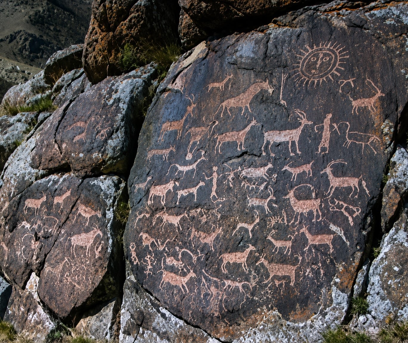
Archaeologists working in southern Kazakhstan have documented more than 1,200 petroglyphs and a rare Old Turkic runic inscription in Burkhansai Gorge. This discovery sheds new light on ancient pastoral life, cultural traditions, and early writing in Central Asia.

The site lies in the Zhualy District of Kazakhstan’s Jambyl Region. Researchers say the rock carvings span several historical periods, from the end of the third millennium BC through the medieval era and later times. The current count is considered preliminary, and archaeologists expect additional discoveries as surveys continue.

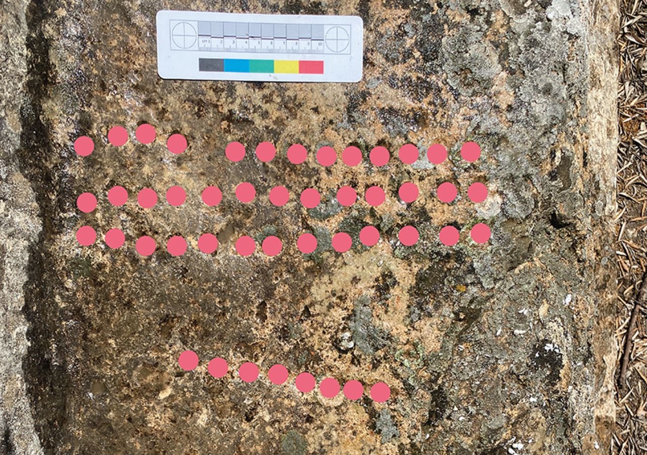
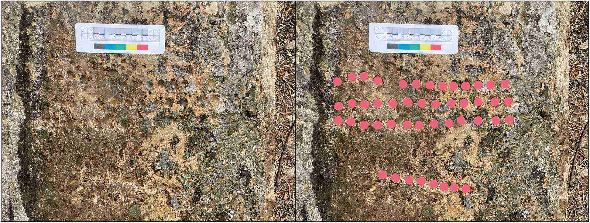
Among the most significant finds is a short inscription written in Old Turkic runiform script. The five-character text has been interpreted as “Er atym Aba,” meaning “My name is Aba.” Researchers believe it may have been carved more than 1,000 years ago.

Rock art reveals a long history of human activity

Researchers say Burkhansai Gorge preserves evidence of human activity across thousands of years rather than representing a single period of occupation.

According to Anatoly Shayakhmetov of the A. Kh. Margulan Institute of Archaeology, the petroglyphs are distributed across five groups that follow the course of a stream through the gorge. The carvings date to different periods, including the Bronze Age, Early Iron Age, Middle Ages, and later historical eras.

Archaeologists have also identified three burial grounds, known as Burkhansai 1, Burkhansai 2, and Burkhansai 3. The cemeteries are believed to date to the Early Iron Age and medieval periods.

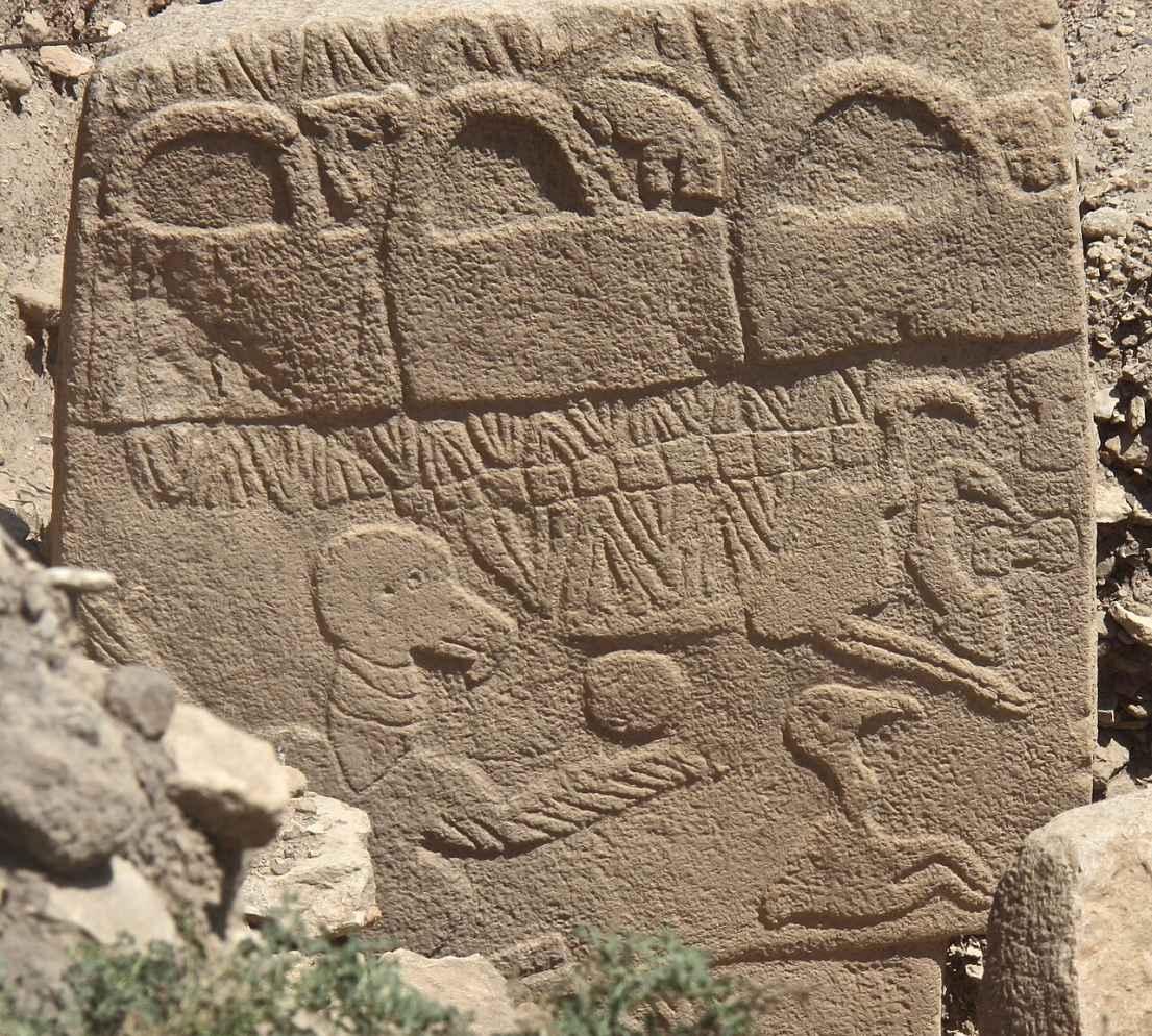
The earliest carvings are estimated to be about 4,000 years old. Many depict goats, one-humped camels, and hunting scenes. Researchers say these images reflect communities that relied on herding and hunting while moving through mountain landscapes.

The combination of rock art and burial sites suggests the gorge served as more than a place for carving images. Researchers believe it formed part of a wider cultural landscape used by different communities over many centuries.

Rare inscription preserves a personal message

A rare Old Turkic runic inscription at Burkhansai Gorge
AI reconstruction of Old Turkic. Credit: Greek Reporter Archive

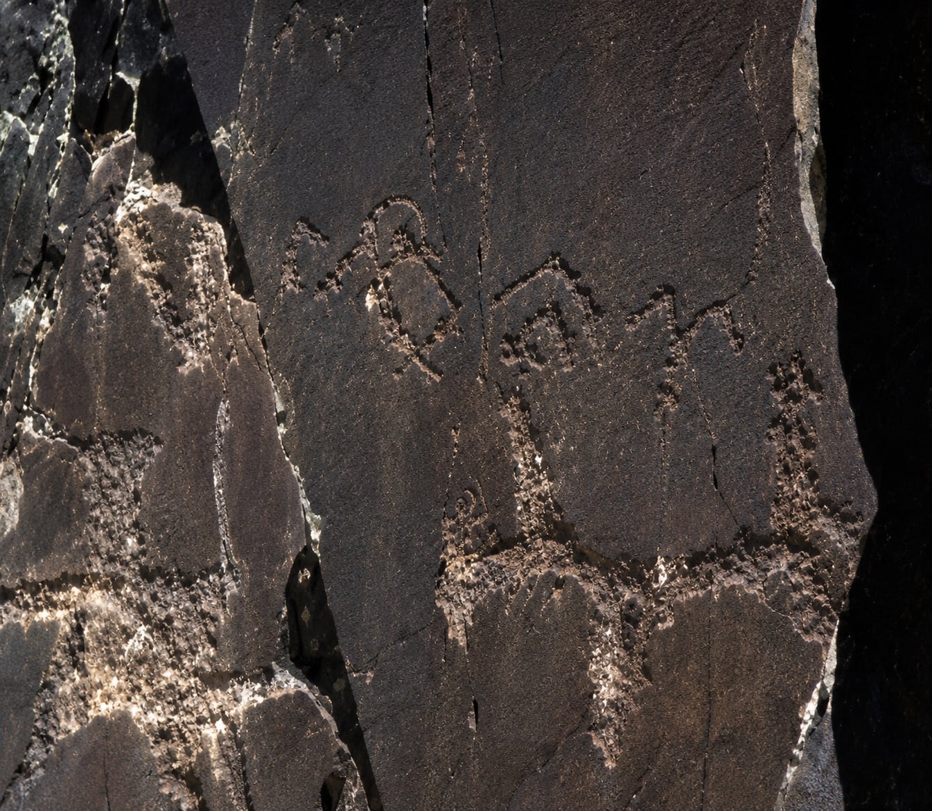
Researchers describe the runic inscription as one of the site’s most important discoveries.

Boris Zheleznyakov of the A. Kh. Margulan Institute of Archaeology said the text was written in the Talas script, a regional form of Old Turkic writing found across parts of Central Asia. He suggested the person who carved the inscription may have been marking his presence or association with the area.

The inscription was later examined by Old Turkic writing specialist Vladimir Tishin, who interpreted the text as “My name is Aba.”

Unlike large royal inscriptions that commemorate rulers or political events, the Burkhansai inscription appears to preserve the words of an ordinary individual. Researchers say that personal quality makes the discovery especially valuable.

The find also contributes to the study of Old Turkic literacy and the spread of writing traditions across Central Asia during the medieval period.

Southern Kazakhstan served as a cultural crossroads

The discovery adds to Kazakhstan’s reputation as one of Central Asia’s richest regions for rock art. Researchers note that mountain gorges and river valleys often acted as long-term cultural archives where generations left carvings, inscriptions, and burial sites.

Southern Kazakhstan was historically connected to the Talas Valley, the Western Tien Shan, and the ancient Silk Road city of Taraz. For centuries, the region served as a meeting point for pastoral groups, traders, and settled communities.

Researchers say Burkhansai’s access to water, shelter, and travel routes may explain why evidence from so many different periods survived in one location.

Researchers plan a further study of the site

Archaeologists are continuing to classify the petroglyphs, investigate the burial grounds, and search for nearby settlements that may help explain how ancient communities used the surrounding landscape.

Researchers also plan to publish a comprehensive study of the site and seek state protection for the archaeological complex.

For now, Burkhansai Gorge stands as a remarkable record of human activity spanning millennia. Its rock carvings reveal how people lived, hunted, and traveled through the region, while a simple inscription preserves the name of one person whose mark on the landscape has survived for more than a thousand years.

  •  

Ancient Burial in Scotland Shows Woman’s Brain May Have Been Removed After Death

Perimortem lesions
Perimortem lesions. Credit: Laura Castells Navarro / CC BY 4.0

Researchers examining the remains of an Iron Age woman in northern Scotland have found signs that her brain may have been intentionally removed more than 2,000 years ago.

The discovery, made at a burial cairn in Sutherland, also revealed long-distance family connections, suggesting prehistoric communities maintained social and cultural ties across wide areas of Scotland.

The findings were published in the journal Antiquity and come from an investigation of two individuals buried in a low stone cairn at Loch Borralie, near the northwestern tip of mainland Scotland. The burial contained the remains of an adult woman and a juvenile boy.

Rare glimpse into Iron Age burial practices

Understanding funerary traditions in Iron Age Britain has long been difficult because human remains rarely survive. Soil conditions often destroy bone over time. North-west Scotland is one of the few regions where environmental conditions have preserved skeletal remains, offering researchers a rare opportunity to study how ancient communities treated their dead.

Researchers from the United Kingdom and the United States examined the remains to determine who the individuals were, where they came from, and whether they were related to each other or other groups in the region.

“We knew that in the north-west of Scotland, including the Northern and Western Isles, the circulation and deposition of human remains were particularly prominent,” said lead author Dr. Laura Castells Navarro of the University of York.

Evidence points to deliberate brain removal

To investigate the burial, researchers combined osteological analysis, isotope testing, and ancient DNA studies.

The most striking discovery involved the adult woman. Researchers found fine cut marks on the inside of her skull and identified unusual modifications to several long bones, including the upper arm, forearm, and thigh bones. The bones had been shaped so that their ends tapered into points.

Evidence of intentional postmortem manipulation
Evidence of intentional postmortem manipulation. Credit: Laura Castells Navarro / CC BY 4.0

According to the researchers, the evidence suggests the woman’s brain was intentionally removed after death, and some of her bones were deliberately carved before burial.

The purpose of these actions remains unclear. However, researchers believe the treatment may indicate that the woman held a special place within her community.

“The motivation behind the extensive manipulation of the skeletal remains of Individual 1 is very difficult to interpret,” Castells Navarro said. “However, the care with which she was reassembled and deposited in the cairn possibly suggests she commanded a level of reverence and respect by her community.”

DNA reveals connections across Scotland

The study also uncovered evidence of extensive mobility among Iron Age communities.

Isotope analysis indicated that both individuals likely spent their childhoods about 80 kilometers southeast of Loch Borralie. Ancient DNA revealed genetic links to people living in Orkney, roughly 175 kilometers northeast of the site, and Applecross, around 225 kilometers to the southwest.

Researchers also determined that the woman and the boy were closely related, most likely maternal second cousins.

The findings suggest that family groups moved regularly around Scotland’s northern coast and islands while maintaining relationships across considerable distances.

“More broadly, our research shows that prehistoric maritime communities periodically moved around the north coast and Northern Isles of Scotland, possibly in small groups,” Castells Navarro said. “This movement allowed for the spread and maintenance of cultural practices and traditions.”

New clues to prehistoric social networks

Taken together, the evidence of possible brain removal, deliberate bone modification, and long-distance family connections points to a complex society linked by shared traditions and social networks.

While researchers cannot determine exactly why the woman’s remains were altered, the burial suggests that some Iron Age communities maintained ongoing relationships with the dead and practiced funerary rituals that extended far beyond simple burial.

The findings provide a rare glimpse into beliefs and customs that shaped life in prehistoric Scotland more than two millennia ago.

  •  

The Colossus of Rhodes: Six Facts About the Wonder of Ancient World

Colossus of Rhodes
Artist’s depiction of the Colossus of Rhodes (one of the Seven Wonders of the Ancient World). Credit: Public Domain.

Most people today know of the Colossus of Rhodes as one of the Seven Wonders of the Ancient World, but there are many little-known facts about the masterpiece that may surprise you.

The ancient island of Rhodes, the kállistin (best) of the Greek cities as historians like to call it, has long attracted the attention of the world due to its beautiful beaches, rich history, and advanced civilization that stretches far back in time.

Rhodes was a city with philosophical and other schools, conservatories, markets, stadiums, harbors, and at least 3,000 public statues.

The masterpiece of all, though, was the Colossus of Rhodes, built between 292 to 280 BC. The huge bronze statue was about 30 meters (98.4 feet) tall and portrayed the god of the Sun, Helios.

The construction of the Colossus lasted for 12 years, but the statue was destroyed a few decades later in 226 BC by an earthquake.

Lesser known facts about the Colossus of Rhodes

The Colossus of Rhodes and the Statue of Liberty

Both monuments were built as symbols of freedom, and people have made the connection between both statues since the Statue of Liberty was created.

The Statue of Liberty has been referred to as the “Modern Colossus” and stands just a little higher at 34 meters (111.5 feet) tall.

There is also a plaque inside the pedestal of the Statue of Liberty that is inscribed with a sonnet title “The New Colossus, not like the brazen giant of Greek fame.”

The debate about the statue’s feet

There has been a debate among historians about whether the statue was standing with one foot on either side of the Rhodes harbor.

Some have discounted this theory and believe that he stood in a more usual Greek statue pose on one side of the harbor.

If the Colossus of Rhodes was built with its legs straddling the harbor, then the harbor would have had to have been closed for 12 years for the initial construction, and then it would have once again been blocked for years when the statue fell.

The statue has an iron skeleton

The statue was actually built with an iron frame like a skeleton over which the Rhodians placed carved and sculptured brass plates to create the outer structure of Helios, creating his muscle and skin.

Chares of Lindos designed the Colossus of Rhodes

We owe the design of the Colossus of Rhodes to Chares of Lindos. Chares was a student of the famous sculptor Lysippus, who had previously created a 19-meter (62 foot) tall statue of Zeus.

The metal used to construct the statue later scrapped, sold

In the 7th century A.D., the Arabs conquered Rhodes and dismantled any remnant of the Colossus of Rhodes after it was toppled by an earthquake and later sold the once beautiful statue as scrap metal.

It took approximately 900 camels to carry away all the scrap metal.

Was the destruction of the Colossus the will of the gods?

Finally, Ptolemy III, the king of Egypt, offered to pay for the Colossus’ reconstruction, but the Rhodians refused because they believed that Helios, having been angered by the construction of the statue, was the one who caused the earthquake that destroyed it.

  •  

Greece and Turkey Establish Permanent Cultural Forum

Greece Turkey Cultural Forum
Greek Culture Minister Lina Mendoni and Turkish Culture and Tourism Minister Mehmet Nuri Ersoy. Credit: Ministry of Culture

Greece and Turkey have established a permanent cultural forum to strengthen bilateral cooperation in cultural heritage, museums, research, education, and new technologies, creating a new institutional framework for dialogue between the two countries.

The Greece-Türkiye Cultural Forum was formally established last week through a Joint Declaration signed by Greek Culture Minister Lina Mendoni and Turkish Culture and Tourism Minister Mehmet Nuri Ersoy during the forum’s inaugural session in Cappadocia. Under the agreement, the forum will meet regularly in both countries and serve as a platform for exchanging expertise and developing joint initiatives. “Culture is perhaps the deepest and most enduring field of communication between our societies,” Mendoni said.

The forum is the latest outcome of efforts to strengthen Greek-Turkish relations following the Athens Declaration on Friendship and Good Neighbourly Relations signed by Prime Minister Kyriakos Mitsotakis and President Recep Tayyip Erdogan in December 2023. It also builds on a Memorandum of Cultural Cooperation signed by the two culture ministers during the 6th Supreme Cooperation Council in Ankara.

Heritage protection and cultural cooperation between Greece and Turkey

During the forum, Mendoni outlined Greece’s approach to heritage protection, noting that Greek legislation safeguards all monuments equally—ancient, Byzantine, Ottoman, post-Byzantine and modern—regardless of their religious or cultural origin. She also stated that all are incorporated into the country’s cultural routes and tourism networks.

Furthermore, the forum featured presentations by officials and experts from both countries on the restoration and conservation of Byzantine and Ottoman monuments, heritage management, historical research, and the use of new technologies in the cultural sector. Discussions also focused on combating the illicit trafficking of cultural goods, an area in which Greece and Turkey have cooperated since signing a bilateral protocol in 2013.

“The exchange of information, the cooperation of competent services and the use of international mechanisms are crucial tools for effectively combating the illegal trafficking of cultural goods and securing their return to their place of origin,” Mendoni said. The Joint Declaration also highlights the importance of digitalization and improving public access to cultural resources through digital technologies, while encouraging closer cooperation in the use of emerging technologies in heritage management.

On the sidelines of the forum, Mendoni thanked Ersoy for Turkey’s support at UNESCO’s Intergovernmental Committee regarding the return of the Parthenon Sculptures. She noted that his confirmation that no Ottoman document ever authorized Lord Elgin’s removal of the sculptures strengthens the international case for their reunification in Athens.

Related: Turkey Deals Blow on the UK’s Legal Claim For the Parthenon Marbles

  •  

22,000-Year-Old Jewelry Reveals Ice Age Social Networks in Spain

Selected personal ornaments from Llonín Cave in northern Spain
Selected personal ornaments from Llonín Cave in northern Spain. Credit: Daniel Pérez-García de los Salmones et al. / CC BY 4.0

A collection of 22,000-year-old jewelry discovered in northern Spain is offering new insights into how Ice Age hunter-gatherers expressed identity, exchanged ideas, and maintained social networks across vast distances.

Researchers found that people living in and around Llonín Cave used shells, animal teeth, bones, and even fossils to create personal ornaments over thousands of years, revealing changing patterns of social life during the Upper Paleolithic.

The study, led by Daniel Pérez-García de los Salmones and published in PLOS One, analyzed 271 ornaments recovered from Llonín Cave in northern Spain. The cave preserves a long archaeological sequence dating from roughly 23,500 to 11,000 years ago, covering several major cultural periods of the Late Ice Age.

A cave filled with symbolic objects

The ornaments included marine shells, red deer teeth, fish vertebrae, bone fragments, and a fossilized tube worm. Most were intentionally modified and worn as pendants or beads. Researchers identified at least 17 genera and 15 species used in their production. Marine shells made up the largest share of the collection, while red deer canine teeth were the most common animal-derived ornaments.

Microscopic analysis showed that many pieces had been worn for long periods. Friction from cords, clothing, or skin leaves polish marks, grooves, and rounded edges around perforations. More than 90% of the analyzed ornaments displayed signs of use.

A new study from Llonín Cave in northern Spain suggests Ice Age hunter-gatherers used shells, animal teeth, bones, and fossils to create ornaments that expressed identity, marked social ties, and connected communities across long distances.#Archaeology #IceAge #Jewelry #Spain pic.twitter.com/DXcBNuubUJ

— Tom Marvolo Riddle (@tom_riddle2025) June 9, 2026

Researchers also found evidence that some ornaments were made inside the cave. Unfinished deer tooth pendants and partially worked animal teeth suggest that people crafted jewelry on site rather than simply acquiring finished pieces from elsewhere.

Long-distance connections across Ice Age Iberia

One of the most striking discoveries involved shells that likely originated from the Mediterranean coast. The species Tritia mutabilis does not naturally occur along the Cantabrian coast of northern Spain, where Llonín Cave is located.

Its presence suggests that people exchanged objects or maintained contact networks stretching hundreds of kilometers across the Iberian Peninsula.

The cave occupied a strategic position between the Atlantic coast, the Ebro Valley, and routes leading toward the Pyrenees. Researchers argue that these pathways helped facilitate the movement of materials, ornaments, and cultural traditions between distant groups.

From individual identity to group identity

The study found that ornament styles changed over time. During the Upper Solutrean period, around 23,500 to 22,000 years ago, jewelry showed great diversity in materials, manufacturing methods, and designs. Researchers believe these ornaments likely served as markers of individual identity and personal expression.

Later, during the Middle Magdalenian period, ornament production became more standardized. Shell beads were more uniform in size and style, and many appear to have arrived at the cave already finished.

Researchers suggest that this shift reflects larger social gatherings where ornaments may have been used to signal group membership or strengthen alliances among different communities.

A window into Ice Age society

The findings suggest that personal ornaments were far more than decorative objects. They helped communicate identity, social relationships, and cultural connections during a time when hunter-gatherer groups were spread across changing Ice Age landscapes.

According to the researchers, Llonín Cave stands out as an important site for understanding how prehistoric people used jewelry to navigate both everyday life and wider social networks. The collection shows that even 22,000 years ago, people were connected through systems of exchange, shared traditions, and symbolic communication that stretched far beyond their local communities.

  •  

8,000-Year-Old Headless Figurines From Anatolia Hint at Neolithic Offering Rituals

AI reconstruction of a Neolithic female figurine discovered at Kanlıtaş mound
AI reconstruction of a Neolithic female figurine discovered at Kanlıtaş mound. Credit: Greek Reporter Archive

Archaeologists in Turkey have uncovered four headless female figurines dating back about 8,000 years, a discovery that is offering new insight into ritual practices among some of Anatolia’s earliest farming communities.

The terracotta figurines were found at Kanlıtaş mound near the Inönü district of Eskişehir in northwestern Turkey. Excavations at the site have been conducted since 2013 under the direction of Anadolu University.

Kanlıtaş is considered one of the earliest known settlements in the region spanning modern-day Eskişehir, Afyonkarahisar, and Kütahya. Researchers say the site provides important evidence about daily life, settlement patterns, and cultural traditions during the Neolithic period.

Figurines discovered inside ancient structures

Professor Ali Umut Türkcan, who leads the excavation team and teaches archaeology at Anadolu University, said the figurines were uncovered within fill layers at the bases of rectangular buildings.

Researchers determined that the artifacts belong to the final phase of the Neolithic period. All four figurines depict women. The largest measures about 12 to 13 centimeters (5 inches) in length, while the others are approximately 5 to 6 centimeters long.

Although female figurines are common at Neolithic sites across Anatolia, the Kanlıtaş examples stand out because of their condition and context. Several were found with their heads intentionally broken off.

Eskişehir’in İnönü ilçesindeki Kanlıtaş Höyüğü’nde bulunan 8 bin yıllık 4 başsız figürün Neolitik dönem yapı ritüellerinde kullanıldığı tespit edildi. pic.twitter.com/MkBkOCI6Wt

— Punto360 (@punto360tr) June 9, 2026

“The presence of headless or broken-headed female figurines in spaces that appear to have been intentionally sealed suggests they may have been left as offerings during the closure of structures,” Türkcan said.

Researchers believe the figurines were deliberately deposited when buildings were abandoned or taken out of use. Similar practices have been identified at other Neolithic settlements, including Çatalhöyük in central Turkey, one of the world’s most extensively studied prehistoric sites.

Distinctive features set the figurines apart

The Kanlıtaş figurines also display characteristics that distinguish them from many other Neolithic figurines found in Turkey.

Türkcan noted that the figures place unusual emphasis on the hip area. This stylistic feature resembles female figurines discovered in parts of the Balkans, particularly regions once associated with the Neolithic Vinca culture.

The similarity suggests that communities living in different parts of southeastern Europe and Anatolia may have shared artistic traditions or symbolic ideas during the Neolithic era.

Discovery may strengthen evidence of cultural links

Researchers also pointed to possible connections between Kanlıtaş and the broader Porsuk cultural sphere of western central Anatolia. Archaeologists have long debated links between the Porsuk culture and Neolithic communities in the Balkans.

According to Türkcan, radiocarbon dating results indicate that the Porsuk culture may predate some neighboring cultural traditions. The findings could help explain how cultural influences spread between Anatolia and southeastern Europe thousands of years ago.

The discovery adds to growing evidence that Neolithic communities maintained complex social and symbolic traditions. The figurines not only provide clues about ritual behavior but may also help researchers better understand cultural interactions across a wide region.

The excavation team plans to publish the findings in a comprehensive scientific monograph and reference volume in the coming years. Further research may reveal more about the role these Neolithic figurines played in the beliefs and practices of early communities in Turkey.

  •  

Peru Geoglyphs Reveal Hidden Links to Ancient Travel Routes

Nazca Lines, Peru
Nazca Lines, Peru. Credits: Diego Delso, CC BY-SA 4.0, via Wikimedia Commons

Ancient Peru geoglyphs in the Chillón Valley near Lima are offering new clues about how early communities may have used and organized the landscape thousands of years ago.

A new study suggests that some of these large ground markings were placed in ways that cannot be fully explained by chance, although researchers caution that the evidence does not yet prove a direct connection to ancient roads or ritual practices.

The research, led by Christian Mesía-Montenegro and published in PLOS One, examined geoglyphs in two areas of Peru’s middle Chillón Valley known as Huarabí and Pichausa.

The study combined field surveys, drone mapping, and statistical modeling to investigate whether the location of the geoglyphs was related to nearby routes used for movement through the rugged valley landscape.

Geoglyphs are large designs or markings created on the ground. Peru is best known for the famous Nazca Lines, but similar features exist in several other parts of the country. Many remain poorly studied compared with the better-known geoglyphs of southern Peru.

Illustrated and photographed ceramic sherds from Huarabí
Illustrated and photographed ceramic sherds from Huarabí. Credit: Christian Mesía-Montenegro / CC BY 4.0

Researchers examine overlooked geoglyph sites

The geoglyphs documented at Huarabí and Pichausa differ from many of Peru’s famous geometric and animal-shaped figures. Instead, they consist of irregular line patterns located within quebradas, or dry valleys, that cut through the landscape.

Researchers conducted systematic surveys between 2021 and 2022 and recorded geoglyphs across multiple sectors of the Chillón Valley. The study focused on four irregular geoglyph groups, two at Huarabí and two at Pichausa. It also examined six locations near Huarabí where surface pottery fragments from the Formative Period were found.

Ancient geoglyphs in Peru's Chillón Valley are shedding new light on how early communities may have used and organized the landscape. pic.twitter.com/HkbOKhx2Ic

— Tom Marvolo Riddle (@tom_riddle2025) June 9, 2026

The Formative Period on Peru’s central coast spans a time when early ceremonial centers, agriculture, and ceramic traditions were developing. Nearby archaeological sites include several U-shaped ceremonial structures that played important roles in the region’s ancient communities.

Statistical tests challenge simple explanations

Rather than simply measuring distances between geoglyphs and routes, researchers used Monte Carlo simulations. This method allowed them to compare the actual placement of the geoglyphs with thousands of hypothetical random placements across the landscape. The results showed a contrast between the two study areas.

At Huarabí, the geoglyphs differed from what would be expected under the researchers’ chance-placement models. At Pichausa, however, the geoglyphs generally matched patterns that could be produced through random placement. The findings suggest that Huarabí may have followed a different spatial logic than Pichausa.

Even so, the researchers emphasize that the results do not automatically mean the geoglyphs were intentionally built beside roads or movement corridors.

Instead, the analysis shows only that the Huarabí geoglyphs were less easily reproduced by the statistical models used in the study. Other factors, including terrain, visibility, erosion, and landscape features, could also have influenced where the geoglyphs were created.

Pottery provides limited clues about age

One of the study’s most important findings concerns chronology. At Huarabí, researchers identified diagnostic pottery fragments that resemble ceramics from the Formative Period. The pottery suggests human activity occurred near the geoglyphs during that era.

However, the artifacts were found on the surface rather than in sealed archaeological deposits. As a result, they cannot directly date the construction of the geoglyphs.

No comparable pottery evidence was discovered at Pichausa, making the age of those geoglyphs even less certain. Because of these limitations, the researchers avoid claiming that the geoglyphs themselves were definitely built during the Formative Period.

Questions remain about ancient landscape use

Researchers conclude that Huarabí should currently be viewed as a geoglyph locality associated with nearby Formative-period activity rather than as a securely dated Formative geoglyph complex.

They argue that future work should focus on obtaining direct dates, studying visibility across the landscape, and developing more detailed models of how ancient people moved through the valley.

While the findings do not solve the mystery of the Chillón Valley geoglyphs, they provide one of the most detailed examinations to date of how these large ground markings may have related to movement, settlement, and ritual activity in ancient Peru.

  •  

Ancient DNA Shows Iberians Maintained Genetic Continuity Despite Greek Influence

AI reconstruction of ancient Iberian people in local community
AI reconstruction of ancient Iberian people in the local community. Credit: GR Archive

Ancient DNA from the bones of Iron Age Iberians shows that these people held onto their genetic roots despite centuries of Greek, Phoenician, and Carthaginian influence along the Mediterranean coast.

A study published in iScience traced genetic changes across northeastern Spain from 775 BC to 50 CE, marking the first time researchers have systematically analyzed Iberian communities from the early Iron Age all the way through Roman conquest.

Daniel R. Cuesta-Aguirre of the Faculty of Biosciences at Universitat Autònoma de Barcelona led the research. Because Iberian adults were cremated, their remains left no usable DNA.

Researchers instead turned to newborn burials found beneath house floors and work areas at three sites: the Vilars fortress, Sant Miquel d’Olèrdola, and El Camp de les Lloses. Of 54 newborns examined, 22 yielded genome-wide data, and nine more contributed mitochondrial markers.

From fortress to Roman hub: three windows into the Iberian past

The three sites covered distinct phases of Iberian history. The Vilars fortress, home to the Ilergetae tribe, was occupied from the 8th to the 3rd century BC and captured the shift from pre-Iberian to full Iberian culture.

Sant Miquel d’Olèrdola, linked to the Cessetani tribe and active from the 4th to the 2nd century BC, reflected an established community with active trade connections.

Iberian Peninsula with the location of the Fortress of Vilars
Iberian Peninsula, with the location of the Fortress of Vilars. Credit: Joan Carbonell-Roca / CC BY 4.0

El Camp de les Lloses, tied to the Ausetani tribe and dated from the late 2nd century BC to the 1st century CE, documented the period of growing Roman presence.

Genetic analysis placed most individuals from the Vilars fortress and Sant Miquel d’Olèrdola firmly within the local Bronze Age population. Their ancestry combined Western Hunter-Gatherers, Anatolian Neolithic farmers, and Steppe-related groups.

Steppe-related ancestry was somewhat higher in Iron Age individuals than in earlier Bronze Age populations from the same region, suggesting gradual internal shifts rather than large outside migrations.

Iberian DNA and Greek and Mediterranean influence

The DNA record of Iberians showed only limited traces of Greek and other Mediterranean genetic influence before Roman arrival. A few individuals carried ancestry linked to North Africa or southwestern Asia, but these were not widespread.

One newborn at Sant Miquel d’Olèrdola had a maternal lineage associated with North Africa. Researchers interpreted this as possibly reflecting a child born to a local parent and someone with Punic or Carthaginian ancestry, consistent with the large amounts of Punic pottery recovered at the same site.

Iberian relief, showing Hittite influence
Iberian relief, showing Hittite influence. Credit: Luis García / Wikimedia Commons / CC BY-SA 3.0

The study also settled a long-standing archaeological debate. Two newborns at Sant Miquel d’Olèrdola, OLE04 and OLE06, were buried with their legs intermingled and no sediment between them, leading earlier researchers to believe they were twins.

DNA analysis proved they were completely unrelated and even carried different maternal haplogroups.

Roman military activity brought new genes to Iberian settlements

At El Camp de les Lloses, the pattern shifted noticeably. Five of the nine individuals showed clear genetic differences from earlier Iberian populations, carrying North African or Iranian Neolithic ancestry absent in previous generations.

Researchers connected this directly to Roman military and commercial activity, as the site served as a logistical hub tied to Roman infrastructure.

Taken together, the results point to a population that stayed genetically stable for centuries before Roman expansion fundamentally reshaped its makeup.

  •  

The Breathtaking Ancient Greek Ruins Found in Italy

Temple of Concordia
Temple of Concordia – Agrigento, Italy. Credit: Public Domain

When you think about Italy and ruins, your mind’s eye automatically brings up scenes of the Roman Forum and the Colosseum. However, Italy is home to countless ruins which are actually ancient Greek—many of which remain in stellar condition.

The country’s mainland, as well as the island of Sicily, are dotted with Greek ruins—some of which are integrated into modern-day cities and are still even used to host events! Others can be found in isolated locations well off the beaten path.

Ancient Greek Ruins of Italy

As you travel through Italy, as you really should if you call yourself a well-traveled individual, be sure to say “Opa!” as often as you say “Mamma mia!” The following are just some of the truly jaw-dropping ancient Greek ruins which are scattered throughout the Italian countryside.

Paestum

Located in southern Italy along the coast of the Tyrrhenian Sea in what was then called “Greater Greece” or Magna Graecia, this was a major Greek city in ancient times. The ruins date back to 600 to 450 B.C. and are some of the best-preserved Greek temples in the world!

Paestum
Temple of Hera, Paestum (Poseidonia) Italy. Credit: Norbert Nagel/CC BY-SA 3.0

The three famous ancient Greek temples at this site are of the Doric type, and the ancient city walls and amphitheater are mostly intact. The bottom section of walls from many other structures are completely intact.

It is an amazing experience to be able to walk along the ancient stone-paved roads and view the buildings along the roadsides just as the ancients did. The site is open to the public, and there is a modern national museum on-site for you to check out as well.

Another plus is that this archeological site is well off the beaten path and is seldom crowded with visitors!

Locri Epizefiri

Also on the mainland of Italy, in Reggio di Calabria, you will come across the ancient ruins at Locri. The ancient city has been mostly taken over by the encroachment of the nearby towns.

Locri Epizefiri,
Locri Epizefiri, greek theater. Credit: Sandro Baldi/CC-BY-SA-4.0

However, the area is very much worth a visit because the atmosphere quiets as you pass through shady olive groves and meander along the overgrown pathways. It is here where you will inevitably, and literally, stumble across a treasure of ancient ruins.

Greek temples, amphitheaters, and the well-known Sanctuary of Persephone grace the Locri area. The magical experience is truly something you shouldn’t miss out on.

On the island of Sicily, some truly remarkable ruins are yours to explore, starting with the still-used ancient Greek Theater of Taormina!

The Ancient Greek Theater of Taormina

With the beautiful Mediterranean sea lapping at the shores below and the active volcano of Etna looming over the city, Taormina is an upscale destination, featuring cultural events, museums, and priceless antiquities—right in the middle of a bustling city!

The ancient theatre of Taormina ruins
The ancient theatre of Taormina. Credit: Public Domain

Here you will find an ancient Greek amphitheater with exquisite views of both the volcano and the sea. While there, you might even be lucky enough to see a show at the ancient theater. It was originally built in 300’s B.C. and subsequently rebuilt by the Romans in the second century B.C.

Valle dei Templi in Agrigento

In Argrigento, you will be treated to refreshing views of expansive fields and woodlands—as well as one of the most pristine ancient Greek ruins in existence in the Valle dei Templi (the Valley of Temples).

Agrigento, ruins
Agrigento, valle dei templi. Credit: Jesper2cv/CC BY-NC-ND 2.0

Many of the temples and ruins here are not fenced off, so travelers may walk inside and be transported back to the fifth century B.C., when the Greeks first built the ancient city of Akragas. One of the most well-preserved Greek temples in the world, the Temple of Concord, is in this valley.

Segesta Archaeological Site

Segesta is located only 70 kilometers (43 miles) southwest of Palermo. Fortunate travelers here can visit what is perhaps the second most well-preserved temple in the world after those in the Valle dei Templi. Segesta also boasts a beautiful amphitheater, situated atop Mount Barbaro, which is also in pristine condition.

Segesta ruins
The Doric temple of Segesta, Italy Credit: Anna & Michal/CC BY-SA 2.0

The temple dates back to the fifth century B.C. and has typical Doric architecture. Each summer the ancient amphitheater hosts a series of classical Greek dramas performed in Italian. If you’re lucky enough to visit during the summertime, be sure to catch a show.

Ancient Greek Colony in Siracusa

A favorite for all are the ancient ruins at Siracusa (Syracuse), where the ancient Greek colony dates back to the 5th century B.C. This area boasts a Greek theater and the Temple of Apollo, which dates back to the 6th century. Siracusa also has the ruins of the famous Altar of Hieron II—the largest altar from ancient Greece!

Ancient ruins at Siracusa
Ancient ruins at Siracusa Il Turista Informato/CC BY-NC 2.0

Located on the southeastern coast of Sicily and founded by ancient Greeks from Corinth, the city of Siracusa was once one of the most powerful city-states of ancient times. It was once described by the Roman orator Cicero as “the greatest Greek city, and the most beautiful of them all.”

Siracusa is so rich in historical treasures that it is listed as a UNESCO World Heritage Site.

Of course, there are many other Greek ruins that you will come across in your travels through Italy and Sicily, and we have merely scratched the surface in highlighting some of the more popular and well-preserved sites.

Be sure to work a little bit of Greek history into your itinerary on your visit to Italia!

  •  

Israeli attack on Tyre in Lebanon kills eight as evacuation ordered for Christian quarter

People flee historic district of ancient city after airstrikes hit residential areas and damage archaeological sites

Israel has bombed the city of Tyre, killing eight and injuring at least 32 people, and struck dozens of other villages in south Lebanon as it issued forced evacuation orders for the historic Christian quarter of the ancient city for the first time.

Israel struck the al-Masaken neighbourhood without warning on Tuesday morning, sending smoke plumes high above the city’s buildings and igniting fires. Further airstrikes were carried out across the city and a series of bombings hit Abbasieh, a village north of Tyre.

Continue reading...

© Photograph: Kawant Haju/AFP/Getty Images

© Photograph: Kawant Haju/AFP/Getty Images

© Photograph: Kawant Haju/AFP/Getty Images

  •  

Long-Assumed Roman Helmet Hoard Off Spain Turns Out to Be Medieval

Details of the overlapping helmets
Details of the overlapping helmets. Credit: Manuel Frallicciardi / CC BY 4.0

Researchers have confirmed that an underwater helmet hoard off Spain’s eastern coast near Benicarló is medieval rather than Ancient Roman as long assumed. The finding places the collection in the late 14th to early 15th century, during a period of intense maritime conflict along the Valencian coast.

The study was led by Manuel Frallicciardi, a doctoral student jointly supervised by the University of Alicante and the University of Salerno, and published in the journal Antiquity. It marks the first time radiocarbon dating has been applied to iron helmets from an underwater site.

Divers recovered the helmets in 1990 from Piedras de la Barbada, a submerged site about six meters (20 feet) deep near Benicarló in eastern Spain. At least forty-three helmets were identified. Split between two institutions, most of the helmets are stored at the Museu de Belles Arts de Castelló, while two conserved ones are on display at the Museo de la Ciudad de Benicarló.

Because the site had also yielded Roman-era artifacts, including ancient amphorae and Punic War-era bronze helmets, early researchers assumed the iron helmets belonged to the same ancient period.

Fabric linings within helmets unlocked dating mystery

Frallicciardi and his team found organic evidence trapped inside the helmets. Marine sediment had sealed fabric linings in place, protecting them from full decay. The fibers, identified as plant-based bast material in a plain tabby weave, were sent to the Beta Analytic laboratory in Miami and the Curt-Engelhorn-Zentrum Archaeometrie in Mannheim, Germany.

Medieval helmets from different viewpoints
Medieval helmets from different viewpoints. Credit: Manuel Frallicciardi / CC BY 4.0

Four of the five radiocarbon results clustered between the last quarter of the 14th century and the early 15th century. One sample returned a date roughly 150 years later than the rest. Researchers linked this to post-depositional contamination. That helmet sat in a more exposed position, and microscopic analysis showed its fibers were more degraded, conditions that could allow younger carbon to infiltrate the sample.

Spain’s underwater helmet hoard links to medieval piracy era

The helmets fall into two types. Most have rounded skull caps with a central ridge, resembling simplified infantry helmets documented in medieval sources, including the Holkham Bible from around 1330 to 1340 and a fresco painted by Jacopo Uccello around 1378. One helmet has a six-panel faceted construction comparable to a kettle hat depicted in a 1437 altarpiece by Hans Multscher.

Frallicciardi noted the helmets predate the era when large Italian and German workshops standardized European armor production. Their simple construction points to smaller regional workshops supplying local infantry markets. The historical context strengthens that picture. From the 1370s onward, Islamic piracy along the Valencian coast intensified sharply, peaking in the final decades of the 14th century.

Communities responded by building coastal towers, fortifying settlements, and mobilizing local militias. Researchers believe the helmets were most likely lost at sea during this period of sustained maritime insecurity.

  •  

Denmark’s 2,500-Year-Old Hole Belts Puzzle Archaeologists

AI view of a reconstructed Iron Age hole belt
AI view of a reconstructed Iron Age hole belt. Credit: Greek Reporter Archive

Archaeologists in Denmark are recreating a puzzling Iron Age feature to understand better its purpose more than 2,500 years after it was built. Known as hulbælter in Iron Age, or “hole belts,” the structures consist of long rows of shallow pits that stretch across the landscape.

Dating to around 500–300 B.C., some extend for hundreds of meters, while others run for several kilometers. Researchers have identified nearly 50 examples across Denmark, particularly in central and western Jutland. Despite decades of study, archaeologists still do not know exactly why the pits were dug.

Hole belts remain one of Denmark’s oldest mysteries

The pits are not graves, ordinary postholes, or waste pits. Instead, they form organized belts three to six meters (9.8 to 19.6 feet) wide, with individual holes typically measuring only 30 to 40 centimeters (0.98 to 1.3 feet) deep.

Similar features have been reported in Sweden and the Netherlands, but they are far more common in Denmark. Their unusual layout suggests they were built for a specific purpose rather than as isolated features.

To investigate, researchers at the Saxo Institute at the University of Copenhagen have launched a large-scale experimental archaeology project.

Researchers rebuild an Iron Age landscape

Led by associate professor Henriette Lyngstrøm, the project brings together 30 archaeology students at Sagnlandet Lejre, an open-air research center and reconstructed Iron Age village.

The team is rebuilding a hole belt from scratch using reconstructed tools and ancient techniques. Researchers are measuring the time, effort, and coordination needed to create the features. The goal is to move beyond theory and test how the belts may have functioned in everyday life.

Digging reveals the scale of Iron Age labor

One part of the project focuses on reconstructed wooden spades based on Iron Age finds. Archaeologists once thought some of these tools may have been paddles. However, traces of soil, stones, and wear patterns suggest they were used for digging.

Archaeologists in Denmark are recreating mysterious 2,500-year-old Iron Age "hole belts" to uncover their purpose.

Were they defensive barriers, storage pits, boundary markers, or something else entirely?#Archaeology #IronAge #Denmark #AncientHistory pic.twitter.com/o3ZrDywejZ

— Tom Marvolo Riddle (@tom_riddle2025) June 8, 2026

Tests showed that wooden spades could create the pits, but the work was slow and physically demanding. The tools also required frequent sharpening.

The findings indicate that constructing long hole belts would have required planning, organization, and coordinated labor. Researchers say such projects likely involved leadership and cooperation within Iron Age communities.

Food storage theory gets a real-world test

Researchers also examined whether some pits could have been used for storage. Graduate student Angelyn Sørensen placed a chicken inside a ceramic jar buried in a reconstructed pit. On a day when air temperatures reached about 20 degrees Celsius, the meat warmed only slightly, rising from around 10 to 12 degrees.

The results suggest that covered pits could help moderate temperatures, although the experiment does not prove a storage function.

Experiments test the defensive barrier theory

The strongest results came from tests of the defensive theory. Earlier studies showed that sheep and cattle could cross similar pit zones without difficulty. However, when researchers staged mock combat exercises, the pits made movement more difficult for attackers.

Participants struggled to maintain balance, move quickly, and fight while crossing the uneven terrain.

Researchers stress that no single explanation has been confirmed. Still, the experiments show that the hole belts were carefully planned features that required labor, organization, and a clear purpose. Their exact role remains uncertain, but the project is bringing archaeologists closer to understanding one of Denmark’s most enduring Iron Age mysteries.

  •  

2,200-Year-Old Roman Basilica Found Near Rome Reveals Rare Painted Female Head

Tusculum, forum. Areas 1 and 2
Tusculum, forum. Areas 1 and 2. Credit: Francesco De Stefano / CC BY 4.0

Archaeologists have uncovered the remains of a Roman basilica at Tusculum, an ancient city located about 30 kilometers (18.6 miles) from Rome, dating it back to the 2nd century B.C.

The discovery places the structure among the oldest known examples of Roman public basilica architecture, adding a significant piece to the puzzle of how Rome shaped its cities during the Republican era.

Researchers from the Spanish School of History and Archaeology in Rome, known as EEHAR-CSIC, made the find in the southern part of Tusculum’s forum. The forum served as the political and social heart of the city.

The basilica had remained hidden beneath later imperial-era structures for centuries. Antonio Pizzo, who leads the project, said the building is one of the earliest known examples of its type and joins a small, well-documented group of Republican basilicas.

Inside Tusculum’s ancient Roman basilica and its rare design

The structure measured 17.7 by 25.2 meters (58 by 82.7 feet). Its monumental facade featured a series of arches resting on nine flat pilasters, an architectural arrangement known as the “Theatermotiv.”

Pizzo noted that if researchers confirm this interpretation, it would mark the first time this design appears in Roman architecture. Until now, this style had only been identified in later, exceptional buildings such as the Tabularium in Rome.

Female protome
Female protome. Credit: Francesco De Stefano / CC BY 4.0

Among the most striking finds was a polychrome stucco capital discovered inside one of the building’s rooms. It depicts a female head rising from a cup of acanthus leaves, flanked by Ionic scrolls and floral motifs painted in white, red, and green.

The timing of the basilica’s construction aligns with the rise of powerful families from Tusculum, including the Mamilia, Fulvia, and Porcia clans.

The Porcia family produced Marcus Porcius Cato, famous for his repeated calls to destroy Carthage before the Third Punic War. Pizzo said these families drove a wave of monumental construction that went hand in hand with Rome’s growing power across the Mediterranean.

Powerful families and a Roman general add historical depth

Researchers also linked the site to Marcus Fulvius Nobilior, one of the most influential figures of the 2nd century B.C.

After defeating the Aetolian League in Greece, he returned to Rome with Hellenistic art and treasures. An inscription found at Tusculum confirms that some of that spoil went to his hometown.

Francesco De Stefano, co-author of the study published in the Journal of Roman Archaeology, said the discovery contributes valuable knowledge about the origins of this building type and key innovations in Roman public architecture.

The EEHAR-CSIC team has worked at Tusculum continuously since 1994, excavating its forum, theater, and baths. In 2023, they also uncovered a well-preserved marble female statue, with further details expected soon.

  •  

New Study Links Göbekli Tepe Symbols to Ancient Trypillia Rituals

The Vulture Stone, featuring carved symbols at Göbekli Tepe
The Vulture Stone, featuring carved symbols at Göbekli Tepe. Credit: Sue Fleckney / Wikimedia Commons / CC BY-SA 2.0

A new study suggests that the carved symbols at Göbekli Tepe may have been part of a sophisticated belief system that connected timekeeping, sacred space, death, and the heavens.

Published in the International Journal of Culture and History, the research by Oleksandr Zavalii compares imagery from the famous Vulture Stone at Göbekli Tepe with ritual symbols from the later Trypillia culture of present-day Ukraine, Moldova, and Romania.

The study argues that both societies may have used similar symbolic frameworks to understand the cosmos and organize religious life.

Göbekli Tepe, in southeastern Türkiye, dates to roughly 9600-8200 BCE and is considered one of the world’s earliest monumental ritual centers. Zavalii focuses on several of its carved pillars, particularly Stele 43, known as the Vulture Stone.

Researchers interpret the Vulture Stone as a cosmological map

The monument features birds, snakes, a scorpion, geometric symbols, and a headless human figure. Zavalii argues that the arrangement was deliberate. The upper portion contains bird figures, circles, and abstract signs that may represent celestial forces.

The lower section contains animals and human imagery associated with the earthly world, death, or the underworld. Rather than viewing the carvings as isolated images, the study interprets them as parts of a broader symbolic language.

The Vulture Stone has attracted astronomical interpretations for years. In 2017, researchers Martin Sweatman and Dimitrios Tsikritsis proposed that some animal figures represented constellations and may have recorded events linked to the debated Younger Dryas impact hypothesis.

Did the builders of Göbekli Tepe share cosmological ideas with ancient farmers?

A new study compares the site's famous Vulture Stone with Trypillia ritual symbolism and suggests both cultures may have used same concepts to understand time, sacred space, death and the heavens. pic.twitter.com/hO1lHtUvYu

— Tom Marvolo Riddle (@tom_riddle2025) June 8, 2026

A later study by Sweatman suggested that V-shaped marks on the pillar could represent a lunisolar calendar. However, these interpretations remain controversial.

Researchers associated with the German Archaeological Institute have argued that repeated rebuilding and possible roofing of the structures complicate claims that the site functioned as an open-air observatory.

Numerical patterns may reflect concepts of sacred time

According to Zavalii, Stele 43 contains eleven rectangular symbols, while some circular enclosures at Göbekli Tepe include eleven T-shaped pillars. The repeated appearance of the number may have marked divisions of the year or important intervals between solar events.

Stele 33 provides additional evidence for this interpretation. The pillar contains snake-like figures, animals, and abstract motifs. Zavalii highlights the recurring numbers two, three, eleven, and thirteen, suggesting they may have been associated with concepts such as duality, solar cycles, and lunar rhythms.

In this reading, thirteen snake heads could symbolize the lunar year, while eleven may relate to the organization of solar time. Rather than functioning as a precise calendar, the symbols may have formed part of a sacred system used to represent the passage of time.

Trypillia comparison reveals shared symbolic themes

The study’s most distinctive contribution is its comparison with the Trypillia culture, which flourished thousands of years later in Eastern Europe.

Zavalii points to similarities between Göbekli Tepe’s symbols and Trypillian ritual objects, temple layouts, and ceramic designs. Particular attention is given to the Nebelivka Temple and distinctive “binocular-shaped” ritual artifacts.

The study suggests these forms, along with circular and crescent motifs, may have expressed ideas about duality, seasonal cycles, and sacred time.

The research does not claim a direct cultural connection between the two societies. Instead, it proposes that early farming communities may have developed comparable symbolic solutions for understanding the relationship between the sky, ritual practice, and community life.

Debate over Göbekli Tepe’s meaning continues

Other interpretations of Göbekli Tepe remain influential. Archaeologist Klaus Schmidt and later researchers emphasized the site’s role as a ritual gathering place linked to ancestor veneration and communal ceremonies.

Additional studies have connected the site’s headless figures, vulture imagery, and human remains to funerary practices and beliefs about death and transformation. Meanwhile, archaeologist Giulio Magli proposed that some enclosures may have been aligned with the appearance of Sirius in the night sky.

Together, these theories highlight the complexity of Göbekli Tepe. Zavalii’s study adds a new perspective by suggesting that the site’s carvings formed part of a larger symbolic system in which architecture, ritual, memory, and celestial cycles were closely intertwined.

  •  

How Ancient Greek Acropolises Went From Civic Pride to Symbols of Tyranny and Oppression

Acropolis of Athens in Greece at night
Acropolis of Athens in Greece at night. Credit: Giles Laurent / Wikimedia Commons / CC BY-SA 4.0

The ancient Greek Acropolises meant very different things to different people across history. A new study finds its symbolic meaning shifted dramatically over centuries, starting as a marker of civic pride and freedom before becoming firmly associated with tyranny and oppression.

Robin Rönnlund, an archaeologist at the University of Gothenburg in Sweden, published the study in the Annual of the British School at Athens. He examined ancient texts from Homer through the second century A.D. and traced how writers, philosophers, and inscription makers actually understood the word “acropolis” across roughly 1,000 years.

The research directly challenges a widely accepted scholarly narrative. For decades, historians described acropolises as prehistoric royal strongholds that were later abandoned and converted into either religious sanctuaries or civilian refuges during attacks.

Scholars built a false narrative around misread Aristotle

Rönnlund traces this narrative back to a misreading of a passage in Aristotle’s Politics, in which Aristotle theorized that acropolises suited oligarchies and monarchies.

Past scholars interpreted this theoretical statement as a historical sequence rather than a practical observation about fortifications, and the misreading quietly shaped academic thinking for generations.

Remains of the Temple of Artemis with the Acropolis, Sardis
Remains of the Temple of Artemis with the Acropolis. Credit: Carole Raddato / Wikimedia Commons / CC BY-SA 2.0

The word itself is also commonly misunderstood. Rönnlund explains “acropolis” does not mean “upper city,” as dictionaries suggest. It more precisely means “the farthest polis” or “the polis on the edge,” and it first appeared in the Odyssey in reference to Troy.

In early Greek poetry, the ancient Greek acropolis carried an unmistakably positive meaning. Simonides described the Acropolis as a symbol of Greek resistance to Persian invaders.

Ancient Greek Acropolis once stood for freedom and pride

Sparta was celebrated as the “acropolis of Greece” in the famous Lysander monument at Delphi. Philosophers extended the metaphor further. Plato called the head the “acropolis of the soul.”

Diocles of Karystos described the mind as a sacred statue placed on the acropolis of the body. These uses reflected strength, protection, and honor.

Acrocorinth, looking north towards the Gulf of Corinth
Acrocorinth, looking north towards the Gulf of Corinth. Credit: Vancouverquadra / Wikimedia Commons / Public Domain

The meaning turned darker as foreign military occupation became widespread. Ancient sources contain 66 passages linking tyrants to acropolises. Plutarch recorded a warning that Caesar should not be established as “tyrant in the acropolis.”

Macedonian forces turned a civic symbol into oppression

After 322 B.C., Macedonian forces systematically garrisoned acropolises across Greece to keep conquered cities under control. Both Demosthenes and Isocrates described how garrisoned acropolises kept entire regions in submission.

Civilian populations almost never used acropolises as refuges, contrary to popular assumption. The sites lacked sufficient water and supplies for prolonged occupation, and literary sources confirm people typically fled to the walled city below or into the countryside during attacks.

Rönnlund reviewed 133 individual acropolises mentioned in ancient sources and calls for future research combining archaeology, epigraphy, and field surveys to properly reconstruct how these sites functioned in ancient Greek life.

  •  

England’s Cerne Abbas Giant Fades Under Changing Weather Conditions

Cerne Abbas giant
Cerne Abbas giant. Credit: richie rocket. CC BY-2.0.

For more than 1,000 years, the Cerne Abbas Giant has stood on a hillside in Dorset, England, surviving wars, epidemics, and centuries of social change. Now, conservationists say increasingly unpredictable weather is threatening the famous chalk figure and forcing an earlier-than-usual restoration effort.

The 55-meter-tall (180-foot) giant, carved into a hillside above the village of Cerne Abbas, is one of Britain’s most recognizable landmarks. The figure depicts a naked man carrying a large club. For generations, residents helped maintain its bright white appearance by filling its outline with fresh chalk.

Today, the site is managed by the National Trust, which has traditionally re-chalked the giant about once every decade. However, conservation teams say changing weather conditions are making that increasingly difficult.

Weather speeds up restoration work

Around 300 staff members and volunteers are taking part in the latest restoration project. The effort involves carrying nearly 17 tons of fresh chalk up the steep hillside and packing it into the giant’s trenches by hand.

Workers first remove old and discolored material before mixing fresh chalk with water to create a paste. The new chalk is then pressed into the outline, helping restore the figure’s distinctive appearance.

The need for faster restoration became clear in 2019 when heavy autumn rainfall washed away much of the newly applied chalk shortly after conservation work had been completed.

England's famous Cerne Abbas Giant has survived for more than 1,000 years. Now, heavier rainfall, algae growth and erosion are forcing conservationists to restore the massive chalk figure earlier than planned. pic.twitter.com/0ShiLZzOYt

— Tom Marvolo Riddle (@tom_riddle2025) June 8, 2026

Conservationists also have concerns about algae growth. Mild, damp winters and warmer summers can create conditions that allow algae to spread across the chalk surface, causing the giant’s bright white outline to appear green and faded.

“In recent years, we’ve noticed algae growth starting to dull the giant’s bright white outline,” National Trust ranger Luke Dawson said.

Dawson cautioned against directly linking the changes to climate trends at a single site. “It’s one of these things we cannot really prove,” he told BBC News. “It is more just observation of what we are seeing up there.”

Researchers continue to debate the Giant’s origins

The Giant’s origins remain one of England’s enduring archaeological mysteries. Over the years, researchers suggested it could represent a prehistoric fertility symbol, the Roman hero Hercules, or even a satirical image of Oliver Cromwell.

Scientific dating has narrowed the timeline considerably. Researchers believe the figure was likely created between 700 and 1100 CE during the late Saxon period.

The Saxon dating has renewed interest in the Hercules theory. In a 2021 study published in the journal Speculum, researchers from the University of Oxford argued that the giant was originally carved as an image of Hercules.

They suggested it may have served as a landmark and gathering point for West Saxon forces during Viking attacks in southern England.

Conservation efforts expand beyond the hillside

The National Trust is also working to protect the landscape surrounding the Giant. A recent fundraising campaign helped secure 130 hectares of nearby grassland containing rare wildlife and important archaeological remains.

“The Giant was never meant to exist in isolation,” National Trust archaeologist Steve Timms said in a press release. He said protecting the surrounding landscape will help researchers better understand how people used and understood the area over thousands of years.

  •  

South African Cave May Hold Oldest Evidence of Human Fire Use

Neanderthals made first fire at a UK site
Ancient fire use. Credit: Steven Miller / Flickr / CC BY 2.0

Researchers studying a cave in South Africa have found evidence that could push the record of ancient fire use back hundreds of thousands of years.

The findings come from Wonderwerk Cave in South Africa’s Northern Cape Province, a site that has produced some of the oldest known evidence of human activity. The study was published in the journal PLOS One.

Researchers uncover evidence in a deeper cave layer

Previous excavations at Wonderwerk Cave revealed signs of fire use about one million years ago. Researchers based that conclusion on burnt animal bones, heat-altered stone tools, and burned sediments found in a layer known as Stratum 10.

In the new study, archaeologists examined an older layer called Stratum 11. There, they found small mammal bones that showed signs of exposure to heat.

To determine the age of the deposits, researchers analyzed cave sediments using magnetostratigraphy and cosmogenic burial dating. Together, the two methods indicated that the remains were deposited between 1.07 million and 1.79 million years ago.

If confirmed, the discovery could represent the oldest evidence yet found for the use of fire by early humans.

New technique helps identify burned bones

Researchers used a method known as bone luminescence to confirm that the fossils had been exposed to fire.

The technique involves shining high-energy blue light onto fossilized bones under a microscope. Burned bones respond by glowing bright red when viewed through a specialized filter. This allows scientists to detect evidence of heating that may not be visible through traditional examination methods.

Researchers at South Africa's Wonderwerk Cave have uncovered burned animal bones dating between 1.07 and 1.79 million years ago. If confirmed, the discovery could represent the oldest known evidence of fire use by early humans.#Archaeology #HumanEvolution #Anthropology #Science pic.twitter.com/PJX3doqUVa

— Tom Marvolo Riddle (@tom_riddle2025) June 8, 2026

The analysis showed that several of the bones from Stratum 11 had been subjected to high temperatures.

Researchers also ruled out wildfires as the likely source of the burning. The fossils were discovered about 30 meters (98 feet) from the cave entrance, deep inside the cave, and beyond the reach of flames from natural fires outside.

Findings suggest repeated fire use

The study does not show that early humans could make fire whenever they wanted. It also does not provide evidence for routine cooking. Instead, the findings suggest that groups occupying the cave may have repeatedly carried fire into the site and managed it there.

Researchers said the pattern and distribution of burned bones in both Stratum 10 and Stratum 11 point to multiple combustion events rather than a single accidental fire.

Because evidence of ancient fire use is often difficult to distinguish from natural burning, the question of when humans first controlled fire remains one of archaeology’s most debated topics. The new findings add important evidence to that discussion and provide a deeper look into the behavior of some of humanity’s earliest ancestors.

  •  

Archaeologists Uncover Rare Medieval Game Board in Morocco

The gameboard in the hammam at Walīla, Morocco
The gameboard in the hammam at Walīla, Morocco. Credit: Tim Penn / CC BY 4.0

A stone game board carved inside a medieval bathhouse in Morocco could rewrite what historians know about board games in early Islamic North Africa.

The discovery, published in the journal Libyan Studies, pushes back evidence for a game still played today by several centuries and sheds new light on social life in one of the region’s earliest Islamic settlements.

Tim Penn of the University of Reading led the study examining a previously unpublished game board at Walila, the site of ancient Roman Volubilis in Morocco. The board was carved into a stone step leading into a cold plunge pool inside a bathhouse, or “hammam,” built in the late eighth or early ninth century.

The structure was abandoned by the tenth or eleventh century. That narrow window gives researchers a rare, secure date for the board, something that is extremely difficult to establish for carved game boards found at ancient sites.

Morocco bathhouse yields a precisely dated medieval game board

The bathhouse was part of a larger complex that researchers believe served as the residence of Idrīs I, the founder of the Idrisid dynasty and one of the earliest Islamic rulers in North Africa.

Idrīs I arrived at Walila in 788 after fleeing the Hijaz and was declared imam by a local Berber tribe. The complex included a domestic building, a reception hall, and a storage compound, all built in a courtyard style more common to the Levant than North Africa.

The game board itself measures roughly 34 by 9.5 centimeters (13.4 by 3.7 inches) and consists of three rows of at least 13 small, shallow holes carved into the stone.

The gameboard in the hammam found in Morocco
The gameboard in the hammam at Walīla (left), with mark-up showing position of holes (right). Credit: Tim Penn / CC BY 4.0

Researchers identified it as most likely used for “tab/sig,” a running-fight game in which two players move pieces across the board from opposite sides, trying to capture each other’s pieces. The game is still played in parts of North Africa, the Middle East, and Turkey today.

Tab identified as Walila’s ancient running-fight game

The identification matters because the first known written reference to tab appears in the work of Egyptian author Ibn Daniyāl, who died in 1310.

The Walila board predates that reference by roughly 400 to 500 years, suggesting the game has a far longer history in the region than texts alone would indicate.

Researchers also ruled out mancala, another widely played ancient game, because the Walila board’s holes are too shallow and too small to hold multiple playing pieces, which mancala requires. The odd number of holes per row also makes the mancala rules impractical.

Similar boards from the early Islamic period have been found in Arabia, the Middle East, and Portugal, but none had previously been confirmed anywhere in North Africa.

The broad distribution of these boards across the early Islamic world, and as far as Scandinavia, where a closely related game called “daldos” or “sahkku” was played, points to the game traveling through trade and cultural networks.

From Arabian trade routes to Scandinavian shores

At Walila, those connections to the east are well documented. Imported coins, glassware, and a wine jar from Egypt and the Levant were all recovered at the site.

The bathhouse itself uses a dry-heat system more closely linked to Levantine construction than to the Roman bathing tradition, further reinforcing ties to the Middle East. Researchers suggest the game may have arrived in Morocco with Idrīs I or members of his entourage.

The board sat at the center of the steps into the plunge pool, fully visible to anyone in the changing room or entering the water. Researchers noted that its prominent placement suggests gaming was openly accepted as part of the social experience of bathing.

Bone dice recovered from nearby buildings at the site further confirm that a range of games, including games of chance, were played at Walila during the early medieval period.

The study calls on archaeologists working across North Africa and the broader Mediterranean to document game boards more systematically, noting that carvings of this kind are routinely left out of excavation reports.

  •  

The Ring of Legendary King Minos: A Tale of Intrigue and Deception

Ring King Minos
Ring of Minos Heraklion. Credit: Wikipedia/Jebulon/Public domain

The story of the ring known as the “Ring of King Minos” sounds like a tale made in Hollywood. It is a mix of ancient Greek history, mythology, and a plot involving a poor boy, a cunning priest, an English archaeologist, and hidden treasure.

The story begins in 1928, when a boy, Michalis Papadakis (1918-1974), accidentally found a ring at the archaeological site of Knossos. The place of discovery alone meant that the ring certainly had a very long history attached to it probably even going back to the Minoan civilization.

Indeed, several decades later, the shiny, gold, seal ring proved to be 3,500 years old (1,500 to 1,400 BC), as archaeologists assured him, and his was the most significant discovery of Minoan Civilization.

The boy’s father, a destitute farmer named Emmanouil, for some unknown reason, hid the ring from his wife and, for another unknown reason, two years later, he handed it over to the village priest, Father Nikolaos Polakis. Yet, before giving it away, he carved a line on the ring with his knife in order to mark its originality.

Father Polakis initially presented it to English archaeologist Sir Arthur Evans with the intention of selling it. However, there was no deal struck between the two since the priest demanded an astronomical amount of money.

In 1933 or 1934, Father Polakis decided to take the ring to the Heraklion Museum. At the time, the distinguished archaeologists, Nikolaos Platon and Spyridon Marinatos, were on the staff of the institution. Platon decided that the ring was genuine while Marinatos believed the ring was a fake.

Since the two archaeologists could not come to an agreement, they decided it was best to return the ring to the priest.

Ring King Minos
The King Minos Ring at the Heraklion Archaeological Museum. Credit: Twitter/Bokeras

However, Platon kept a copy of the ring by casting it in plasticine. The cast was later located in Platon’s archive. Several years later, he manifested a new interest in the ring and returned to the priest to ask for it. Father Polakis told him that he had given it to his wife for safekeeping, but she had lost it.

Minos ring depicts three themes

Platon wrote a treatise on the ring saying that it depicts three themes: the Minoans’ rule of the seas (“thalassocracy”), tree worship (dendrolatry), and a goddess descending from heaven to earth and getting into a row boat.

There are other, more recent interpretations of the depictions of the ring including the worship of goddesses, such as Mother Dimitra, and offerings to the Great Mother Rhea and the Great Mother Artemis.

For some time, the ring remained lost. The only information about the ring came from the copies that had been made and a number of archaeological reports which were associated with those copies.

Many years later, when Father Polakis was in his final days, he felt great regret about the “disappearance” of the precious ring. He called Evangelia Papadakis, the wife of the farmer Emmanouil, and apologized for lying to her family. He admitted that he had actually sold the ring to Evans, the English archaeologist, for 100,000 drachmas back in 1938.
However, that was one last lie by the cunning priest. What he had actually sold to Evans was a fine replica of the ring.

Evans had returned to England with the belief that he had bought the actual ring, along with a copy, and donated both, along with other precious artifacts, to the Ashmolean Museum. Today, two replicas of the legendary ring continue to be exhibited at the Ashmolean.

The story of the ring was forgotten for decades, but in the early 2000s, Giorgos Kazantzis, a retired police officer, inherited the house of the priest who was the last person in Greece who had had possession of the priceless artifact.

During renovation work, Kazantzis found a jar hidden inside the wall next to the fireplace. Inside the jar was a ring, which indeed proved to be the original Ring of King Minos. It even had the scratch made by Papadakis over seventy years ago.

Kazantzis delivered the precious artifact to the state, and in 2002, the Central Archaeological Council and a panel of expert archaeologists confirmed the authenticity of the ring. The actual monetary value of the ring was estimated to be €400,000 although its cultural value is incalculable.

Yet, for finding the ring and promptly delivering it to the appropriate authorities, Kazantzis was given a measly finder’s fee of €440.

Today, the priceless, gold Minoan ring is exhibited in all its splendor at the Heraklion Archaeological Museum.

  •  

Mithridates’ Kingdom: What Alexander’s Empire Could Have Been?

Marble bust of the king of Pontus Mithridates VI as Heracles, a mythical association that Alexander the Great often touted.
Portrait of the king of Pontus Mithridates VI as Heracles, a mythical association that Alexander the Great often touted. Marble, Roman imperial period (1st century), Credit: Musée du Louvre, Paris, Public Domain.

Alexander the Great’s (356-323 BC) death meant his vision for a Greco-Persian Empire was extinguished with him—or was it?

A hodgepodge of East and West, Mithridates’ Pontic Empire emerges as a compelling possibility of what Alexander’s empire could’ve been, a faint apparition of that fleeting dream.

Alexander 2.0

Mithridates (135–63 BC) was the inheritor of two cultures and, naturally, an incarnation of two worlds. He delighted in his Macedonian heritage as much as his Persian forbearers.

Claiming Macedonian ancestry on one side and Persian dynastic lineage on the other, Mithridates used his mixed descent to reveal the commonalities between his diverse subjects.

Taking on Alexander’s mantle of global empire, Mithridates envisioned an alternative to Roman supremacy, a new world order.

To achieve this ambitious aim, the Pontian King united his Greek, Anatolian, and Persian subjects under an anti-Roman cross-cultural coalition.

The result of this cooperation was three wars mounted against Rome, wars that escalated to the point of genocide.

How could he amass such a diverse following against such a formidable foe?

Mithridates took a page from Alexander’s book and embodied East and West, both in appearance and idea. 

Pontus: Alexander’s vision of empire?

Map of the Kingdom of Pontus, Wikimedia
Map of the Kingdom of Pontus. Credit: Photograph by Javierfv1212,  Public Domain, via Wikimedia Commons.

Mithridates hailed from the Kingdom of Pontus, a cultural melting pot that Alexander the Great would have approved of.

The north of Pontus’s snow-clad Alps was a largely Hellenic-dominated coastline. There, Greek colonists had erected the city of Sinope, Mithridates’ capital.

The historian Strabo, himself a Pontian, claimed that it was “the most noteworthy of the cities in the region.”

South of the Alps was known as Katpatuka (land of horses) by the Iranians and, later, Cappadocia by the Greeks. There, villages predominated apart from a few settlements, such as Amaseia, Strabo’s hometown, and Cabeira.

While Hellenic culture dominated the coast, the Cappadocian hinterland preserved its old Anatolian non-Greek heritage. Rostovtzeff (1932), a pioneer in Pontic history, described the Hellenic influence around the Black Sea as “a thin Greek shell around a hard native kernel.”

The third influence on the region was Iranian. The enduring relics of Persian rule would have been visible to many a Hellenistic Pontian. Strabo says that the Pontic people took sacred vows at the state temple, Zela, which were dedicated to Persian deities: Anaitis, Omanus, and Anadatus.

Moreover, Zeus Stratios, most likely a syncretic reincarnation of Ahura Mazda, received lavish offerings from Persian Kings, which Pontian rulers, including Mithridates Eupator, continued. The continuation of Persian religious customs well after an eclipse of Achaemenid authority attests to the impression Persian presence had made on Pontic royalty and their subjects.

In the subsequent Hellenistic period, the increasing pace of Hellenization of the kingdom meant that the Mithridates Dynasty had to evolve.  There needed to be a balance between the new incoming wave of this ancient form of globalization with their Perso-Anatolian traditions that still held sway in their domain. 

Divine descent

A coin of Mithridates Eupator depicted as Dionysus
Mithridates Eupator depicted as Dionysus, Credit PHGCOM, Public Domain, via Wikimedia Commons.

Mithridates Eupator’s dual lineages afforded him illustrious ancestors and a unique hybrid set of dynastic customs. He was a Helleno-Persian Prince who practiced mixed religious rites.

Mithradates divine connections are well in accordance with Alexander the Great’s own claims. Like the Pontic King, Alexander claimed Heracles and Dionysus, among other numinous figures, as ancestors.

Consequently, the Pontic King embodied redemptive qualities resonating in the Greek and Perso-Anatolian worlds. For the Greeks, he established a mythical connection with Dionysus, the god of liberation and new beginnings, and took the theonym Mithridates Eupator Dionysus.

Likewise, Mithridates claimed heritage from Herakles, who emancipated the titan Prometheus, humanity’s creator. On the other hand, Mithridates’ star-signaling birth was said to fulfill Persian prophecies of a coming savior from the East, as did his name, “Mithras-sent.” 

Global principles

An vase painting of a Persian Magus-king conducting a fire ritual. Mithradates' fire ceremony followed the traditional customs of his Persian ancestors. Detail from red-figure vase 3297, side A, by the Underworld Painter, 4th century BC.
Persian Magus-king conducting a fire ritual. Mithradates’ fire ceremony followed the traditional customs of his Persian ancestors. Detail from red-figure vase 3297, side A, by the Underworld Painter, 4th century BC. Credit: Staatliche Antikensamm lungen und Glyptothek, Munich, Public Domain

In addition to religious mediation, Mithridates weaponized the growing resentment of his subjects. Just like Alexander’s vision for his diverse empire, the Pontian King tried to respect Greek and Iranian values.

Both Greeks and Perso-Anatolians were chafing under Roman occupation. In mainland Greece and Anatolia, the common hatred towards Roman rule provoked a transcultural antagonism against Roman hegemony.

Debt accrued by Roman taxation hindered asa or Truth, a prominent Persian tenet. For the Greeks, Roman occupation was seen as compromising their eleutheria, or freedom, which was fundamental to Greek identity.

Mithridates acknowledged these grievances in his speeches, along with coins and other allusions. By showing sensitivity to both cultures, the Pontian King illustrated how compatible Iranian and Greek cultures could be.

This may be surprising, considering the tumultuous history that plagued the relations between Greeks and Iranians. Egregious crimes were committed in Athens by the Persians and by Greeks in Persepolis at Alexander’s instigation as punishment.

Yet Mithridates successfully harmonized the two cultures, as Alexander the Great’s policies aimed to accomplish.

Was Mithridates’ Pontian kingdom what Alexander’s empire could have been?

Sensitive to Greek and Perso-Anatolian culture, Mithridates entangled much of the Eastern Mediterranean in opposition to Rome. Mithridates carried on Alexander’s vision for an international empire even though he was unsuccessful in his wars against Rome. By doing so, the Pontian king proved Alexander the Great’s Helleno-Persian hypothesis was possible.

Alexander’s vision for joining East and West wasn’t an idyllic dream but was ultimately an achievable reality. 

  •  
❌