President Trump claimed Wednesday that the U.S. secretly moved over 100 million barrels of oil through the Strait of Hormuz. Trump in a Truth Social post said he “directed” the military to “execute a secret mission to support Oil Tankers and other Commercial Ships” through the strait. “I am pleased to announce that this effort…
President Trump claimed Wednesday that the U.S. secretly moved over 100 million barrels of oil through the Strait of Hormuz. Trump in a Truth Social post said he “directed” the military to “execute a secret mission to support Oil Tankers and other Commercial Ships” through the strait. “I am pleased to announce that this effort…
The Environmental Protection Agency (EPA) replaced employee desk phones with calling software used on their laptops, something the union says poses safety issues, including during a recent medical emergency. Justin Chen, president of the biggest EPA employee union, told The Hill that the additional software that’s supposed to handle 9-1-1 geolocation “doesn’t really work, apparently.”…
The Environmental Protection Agency (EPA) replaced employee desk phones with calling software used on their laptops, something the union says poses safety issues, including during a recent medical emergency. Justin Chen, president of the biggest EPA employee union, told The Hill that the additional software that’s supposed to handle 9-1-1 geolocation “doesn’t really work, apparently.”…
Chinese scientists have discovered a massive whale graveyard of around 500 skeletons, some dating back to more than 5 million years, at the bottom of the Indian Ocean west of Australia, according to research published in the journal Nature on Wednesday. The whale fall provides shelter and sustenance to a vibrant ecosystem of marine species, many believed to be new to science.
DEDURU OYA, Sri Lanka – On April 16, eight members of Priyantha Kumara’s family including his wife, son, brother, father-in-law, and four other relatives were swept away by strong currents in the Deduru Oya, a river in Sri Lanka’s North Western province. Sri Lanka Police reported more than 30 drowning deaths between April 12 and 21 this year, underscoring the risks posed by flooding rivers. Sri Lanka Police media spokesperson Udaya Kumara Wootler told Mongabay that 376 individuals have died due to drowning in rivers last year while 595 fatalities were reported in 2024. Buddhika Sampath, spokesperson for the Sri Lanka Navy told Mongabay that the Navy Diving Unit recovered 148 bodies of people between May 2022 and May 2023. While the police are yet to disclose official statistics of deaths due to drowning from January to May 2026, the number of reported incidents show over 50 fatalities. Kumara is a resident of Gopallawa in the northwestern district of Kurunegala. His son had requested that they all go for a bath in the river. The group had been bathing at a popular spot named Kuriyagas Mankada when they met the tragedy. “My son was only 13 years old, and he was a bright student,” Kumara told Mongabay. “My brother was about to hold a housewarming ceremony at his newly built house. But all these dreams were shattered within seconds. My father used to take us to this same spot to bathe when we were young. But the river has changed…This article was originally published on Mongabay
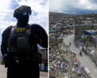
The U.S. military disabled an oil tanker in the Gulf of Oman on Tuesday after it said the vessel violated the ongoing U.S. naval blockade, the U.S. Central Command announced on Wednesday, but the kinetic action has drawn pushback from India, which said three Indian crew members are now missing. A U.S. aircraft fired precision…
The U.S. military disabled an oil tanker in the Gulf of Oman on Tuesday after it said the vessel violated the ongoing U.S. naval blockade, the U.S. Central Command announced on Wednesday, but the kinetic action has drawn pushback from India, which said three Indian crew members are now missing. A U.S. aircraft fired precision…
Critically endangered Tapanuli orangutan population falls after heavy rain and landslides, fuelled by climate crisis, in North Sumatra
Extreme rainfall and landslides fuelled by the climate crisis killed 7% of the remaining population of the world’s rarest great ape, a study has found, prompting fears for the species’ survival.
The research suggests 58 out of the remaining 800 critically endangered Tapanuli orangutans (Pongo tapanuliensis) were killed after more than 1,000mm (39in) of rain fell over four days in Indonesia’s North Sumatra province in November 2025. This equates to 11% of the local population and 7% of the entire species.
Enfield council in north London took legal action against restaurant chain after outrage over damage to tree
The UK restaurant chain Toby Carvery has settled a legal dispute over taking a chainsaw to an ancient oak tree without permission, by agreeing to pay to restore a lost orchard.
The unauthorised partial felling of the 500-year-old oak next to a Toby Carvery car park in Whitewebbs Park, Enfield, north London, in April last year, prompted widespread public outrage and questions in parliament.
Donald Trump’s immigration crackdown is largely targeting people from the countries most vulnerable to displacement from climate-driven disasters, a Guardian analysis shows.
As the Trump administration pushes policies to boost planet-heating fossil fuels, millions of people are being forced to flee their homelands due to storms, floods and droughts worsened by the climate crisis.
Τhe decommissioned naval ship A/B Folegandros Is being scuttled using controlled explosive charges. Video screenshot.
In the coastal waters of Chania, Crete, decommissioned navy vessels are being scuttled to create Greece’s first highly regulated, wreck-based scuba diving park.
The ambitious underwater project by the municipality of Apokoronou at Omprogialos already features 44 deployed artificial reefs alongside the decommissioned Hellenic Navy vessel Nestor. On Wednesday, the park adds its newest centerpiece: the decommissioned naval ship A/B Folegandros, which is scheduled to be scuttled using controlled explosive charges.
Θάλασσα Χανίων Το ανατίναξαν για καλό σκοπό… Στον Ομπρόσγιαλο Χανίων δημιουργείται το πρώτο οργανωμένο καταδυτικό πάρκο της Ελλάδας. Μετά τους 44 τεχνητούς υφάλους και το «Νέστωρ», βυθίζεται σήμερα το παροπλισμένο «Α/Β Φολέγανδρος» σε βάθος περίπου 25 μέτρων. pic.twitter.com/OjcV1SIXvY
— Αντώνης Νταλακογεώργος (@Adalakogeorgos) June 10, 2026
Hellenic Coast Guard vessels and an elite Navy Underwater Demolition Command (OYK) unit are currently on-site overseeing the operation. Following detonation, the vessel will settle on the seabed at a depth of approximately 25 meters (82 feet).
To ensure public safety, maritime authorities have enacted stringent security measures across the broader Ompros Gialos sea area. A strict multi-kilometer exclusion zone has been established, completely banning the approach, anchoring, or transit of any vessel within a one-kilometer radius of the scuttling site. The Hellenic Coast Guard has been actively patrolling the perimeter since the early hours of the morning and will maintain surveillance until the operation is fully finalized.
A scuba diving park
The scuttling of the Folegandros is a pivotal step toward finalizing the Apokoronou Diving Park, a cornerstone project in the region’s strategic push to develop high-end, niche tourism markets. The diving park, which will be owned and operated directly by the Municipality of Apokoronas, features three distinct underwater routes designed for varying exploration levels:
Route 1: The Eco-Trail — Navigating through the network of 44 artificial reefs, submerged at a highly accessible depth of 9 to 10 meters (30–33 feet)
Route 2: The Nestor Wreck — Centered around the previously scuttled Hellenic Navy ship
Route 3: The Folegandros Deep Wreck — Descending to the newly scuttled vessel at 25 meters, geared toward intermediate and advanced divers
A catalyst for alternative tourism
Local officials aim to have the diving park fully operational by the end of the current 2026 tourism season.
Hailed as one of the most significant alternative tourism infrastructures in Chania and the wider island of Crete, the park is projected to become a premier hotspot for international and domestic diving enthusiasts. Beyond the economic boost, this dedicated “shipwreck museum” is designed to act as a marine sanctuary, generating a highly positive ecological footprint by fostering localized marine biodiversity and promoting sustainable eco-tourism in the Aegean.
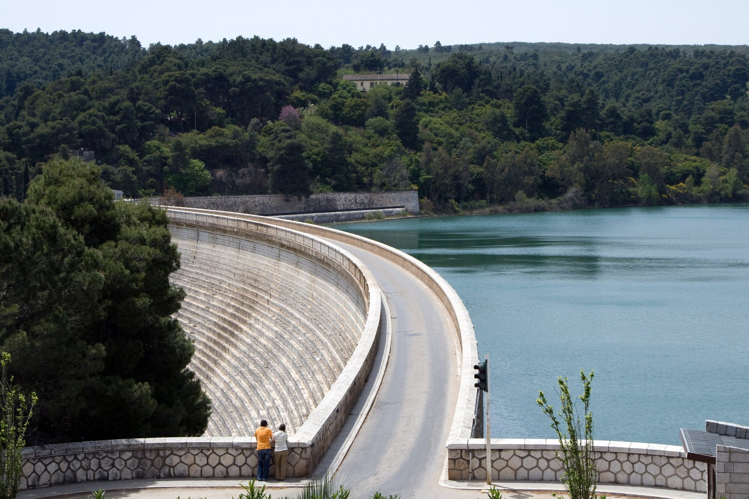
Lake Marathon Dam in Greece. The country’s aging water networks are facing growing pressure from water loss, drought, and rising investment needs. Credit: Vitaly / Wikimedia Commons / CC BY-SA 3.0
Water loss in parts of Greece’s aging water networks exceeds 50 percent, according to a new analysis by EY-Parthenon, highlighting the urgent need for infrastructure upgrades and a new approach to water management.
The report warns that climate pressures, prolonged drought, declining water reserves, and outdated infrastructure are pushing Greece’s water sector to a critical turning point.
Greece’s water networks are now increasingly viewed as core national infrastructure with direct implications for economic stability, environmental protection, and long-term public planning.
A loss of over 50% in some of Greece’s aging water networks
According to EY-Parthenon, the global strategy consulting arm of Ernst & Young (EY), water losses across Greek networks exceed 30 to 40 percent in many cases, while certain areas face losses of over 50 percent. The high losses reflect aging infrastructure, insufficient maintenance, limited monitoring of water flows and consumption data, and the need for more efficient management systems.
The analysis also notes that water reuse remains extremely limited in Greece, at around two percent. At the same time, irrigation accounts for approximately 85 percent of total water consumption. More than 70 percent of irrigation water comes from underground reserves, which highlights the need for more efficient resource use and a more pronounced shift toward circular water management.
Fragmented water sector faces growing pressure in Greece
EY-Parthenon identifies fragmentation as one of the main weaknesses of Greece’s water management sector. The market includes 129 municipal water and sewage companies, more than 450 irrigation organizations, and a broad network of local authorities. This dispersed operating model makes coordination harder, limits economies of scale, and slows modernization projects.
The challenge becomes more urgent as the sector faces increasing demands related to resilience, governance, service quality, and regulatory compliance. Numerous smaller providers remain under financial pressure, as revenue from water bills often does not fully cover operating costs or support major infrastructure investments.
Greece’s water infrastructure needs reach €10 billion
Although the sector faces serious structural problems, EY-Parthenon sees significant room for investment in Greece’s water market. The country’s medium- and long-term infrastructure needs stand at around €10 billion ($11.5 billion). Meanwhile, Greece’s two largest water companies have planned or ongoing investments that exceed €3 billion ($3.46 billion).
These investments focus on network upgrades, expansion, modernization, and efficiency improvements. According to the report, investor confidence in the sector also continues to rise, as shown by the recent market performance of listed companies operating in the water industry.
New rules could reshape Greece’s aging water networks
Changes in Greece’s regulatory framework could further transform the sector. The expanded role of the Regulatory Authority for Waste, Energy and Water (RAAEY), stricter European obligations on wastewater management, and efforts to reduce fragmentation are shifting reform from discussion to implementation.
These changes create opportunities, but they also impose new requirements on water providers. They call for greater transparency, more rigorous reporting obligations, improved accountability, and more reliable long-term planning. EY-Parthenon emphasizes that the sector’s future challenges are not only technical. They also involve financial sustainability, pricing policies, digital transformation, investment priorities, and cooperation between public and private stakeholders.
Warnings of a powerful El Nino weather pattern this year suggest that we may be about to face drought, flooding and extreme heat. What impacts are in store? And can we prepare for the worst of it?
A stunningly unique phenomenon of geology in Greece: The Folded Marls near Agios Pavlos, on the island of Crete. Credit: Tony Cross.
By Tony Cross
Greece and its geology are a wonder of nature, with the nation a paradise blessed with high mountains, blue seas, and over six thousand islands. But it’s all a big geological accident, the result of millions of years of violent earth movements on a planetary scale.
Geology in Greece: in the beginning…
The story of Greece and its geology begins around 250 million years ago when the continents had all come together into one single land mass that geologists call Pangea.
The area that would one day become Greece lay on the southern shore of what would eventually become Europe and on the northern edge of a great ocean called Tethys. On the southern edge of Tethys lay the continent that would one day become Africa.
The Earth’s crust is not all the same, nor is it a single unit. The crust making up the continents is very thick—30 km to 40 km (18.6 to 24.85 miles) thick—and thicker still under mountain ranges. The crust under the oceans is quite thin, however, at only around 7 km (4.3 miles) thick.
In addition, the crust is not one single unit but is broken up into various-sized chunks known as tectonic plates. These plates move relative to one another because they are literally floating on the deformable layer of the upper mantle beneath them in much the same way that a ship floats on the sea.
In some places, these plates are moving together, and where oceanic crust is pushed into continental crust, the thinner oceanic crust is forced beneath the thicker continental crust and down into the mantle, where it begins to sink and melt. Geologists call this type of plate boundary a subduction zone.
The Greek landscape and geology that we see today is here because of a subduction zone. Without it, Greece would simply not exist.
The compressive phase
Around 150 million years ago, the great continent of Pangea started to break up. The African plate began to move northwards, and the Tethys Ocean started to shrink. The northwards movement of Africa meant that the oceanic crust beneath Tethys was subducted under the southern edge of the continental crust of Europe.
As the oceanic crust under Tethys slid beneath the continental crust of Europe, all of the rocks that had formed on the ocean floor over many millions of years were scraped off by the leading edge of the European continent. These rock scrapings, which would have been hundreds of meters thick and many kilometers long, were piled up one on top of the other on the southern edge of Europe.
This rock pile (geologists call it a nappe) was likely many kilometers thick in the end. It contained all the rocks that would eventually form Greece’s geology all piled up in the same place.
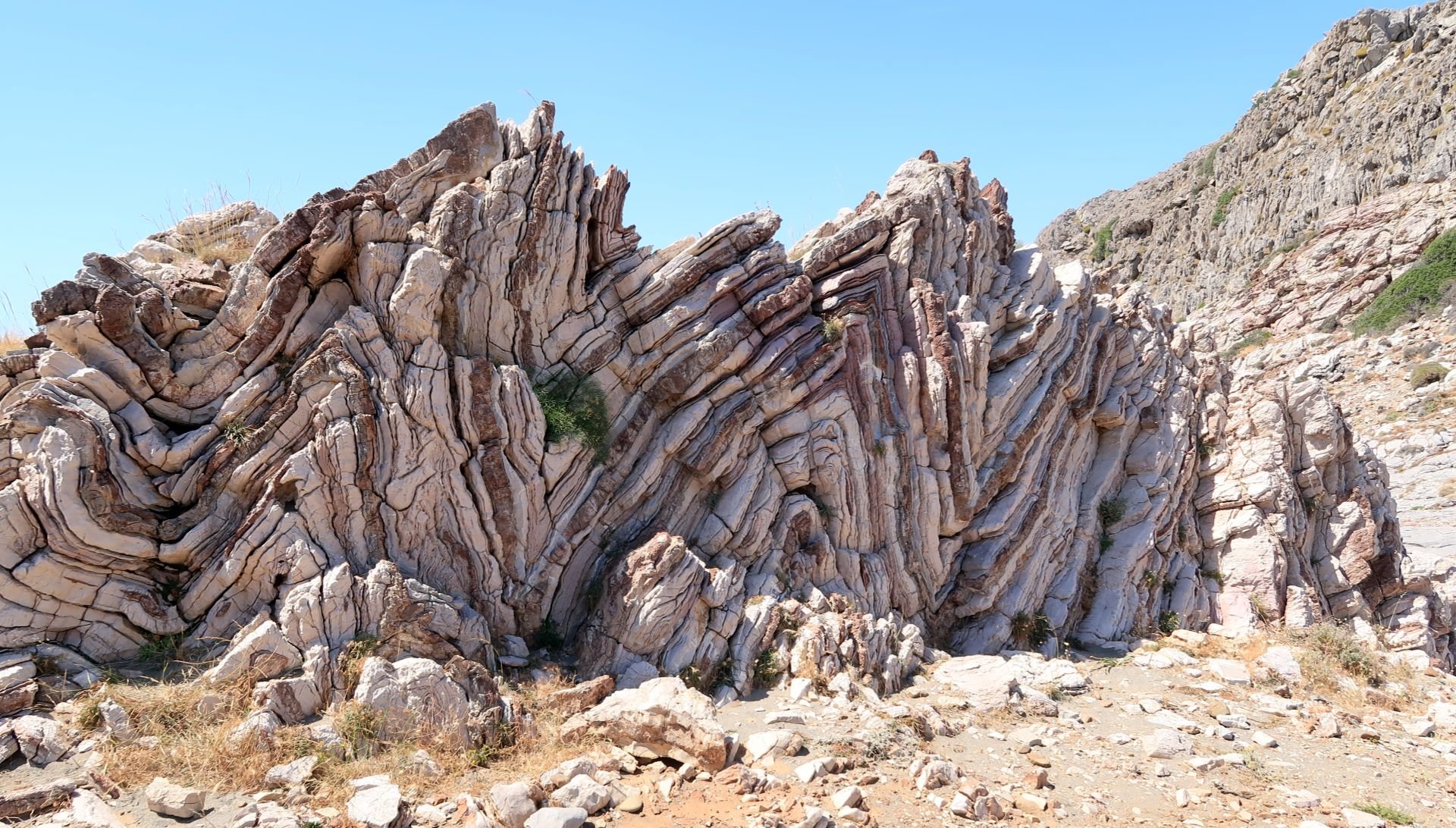
A thrust fault near Kavousi, Crete. Credit: Tony Cross.
The photo shown here is of a large sea cliff near Kavousi on Crete. The rocks on the left are a gray color with clearly defined horizontal layers. Those on the right are a greenish brown color with a nearly vertical layering. Clearly, this cliff is composed of two very different rock types.
The rocks on the left are limestones while those on the right are phyllites. The compressional forces of the subduction zone forced the phyllites over and on top of the limestones. The junction between the two (known as a thrust fault) lies roughly in the center of the picture, running diagonally up from right to left.
Millions of years of weathering and erosion have ground both sets of rocks down so that to the casual observer today, they appear to be a single unit.
The tensional phase
Around 65 million years ago, the continent of Africa finally collided with the continent of Europe and closed the Tethys Ocean forever. It would eventually be reborn as the Mediterranean Sea.
When two continental plates come together, there is no subduction since they are both too thick. Instead, the continents themselves are deformed, and mountains are created. In the west, this collision formed the Alpine mountains while in it formed the Balkan mountains in the east.
In these mountain areas, the continental collision destroyed the subduction zone, but in the area in between, where modern Greece lies, the subduction zone remained active.
Even though Africa could no longer move northwards as fast as was previously the case, the oceanic plate in the area of Greece was still sinking into the mantle. As it sank, the subduction zone itself rolled back southwards. This rollback of the subduction zone put the nappe pile under enormous tension.
When rocks are placed under tension, they break, causing normal faults. One side of the fault moves downwards on a sloping surface to relieve the tension. Normal faults often occur in parallel and in swarms leaving alternating areas of high ground with lower ground in between.
The rollback of the subduction zone caused massive parallel swarms of normal faults in the nappe pile. Because the subduction zone is fixed in the east and in the west, the rollback created an arc that is ever expanding as the rollback progresses.
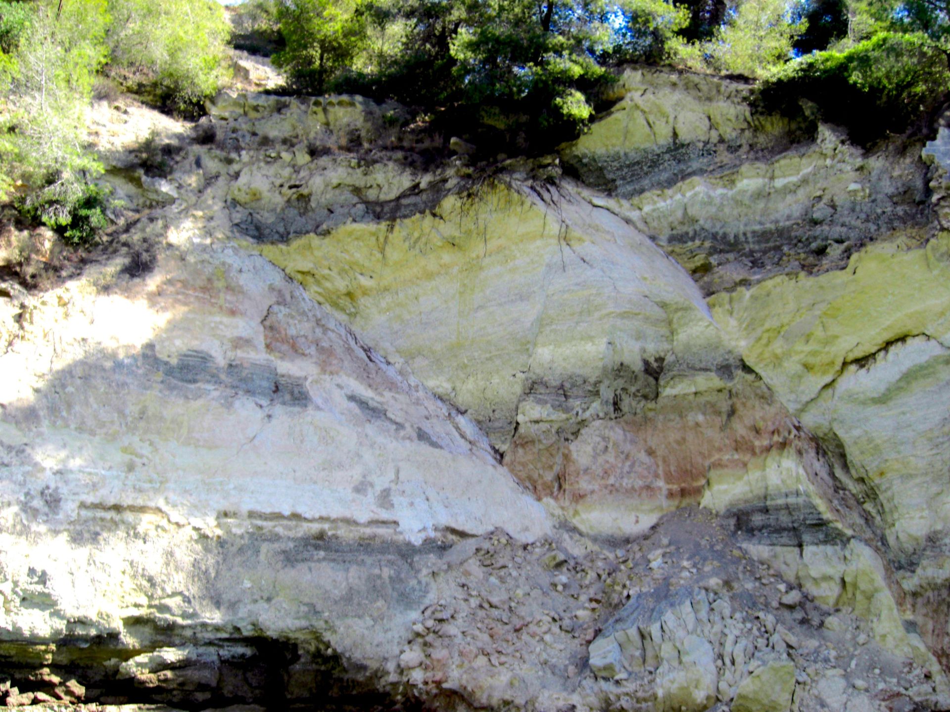
A normal fault in the Corinth Canal. Credit: Tony Cross
The photo above is of a small section of the north wall of the Corinth Canal. The rocks here are nicely layered; we can see yellow, white, red, and black layers.
The two diagonal lines in these rocks are normal faults, breaks in the rocks caused by tensional forces due to the rollback of the subduction zone. The rocks to the right of each fault have dropped down relative to the rocks on the left; this is clearly visible in the displacement of the colored layers of rock.
The total vertical displacement here is only a few meters, but in the massive regional faulting that shaped Greece and its geology, displacements are measured in kilometers.
The modern topography of Greece
Looking at a topographical map of Greece today, you can see how a subduction zone, starting roughly in the area of the north Aegean and rolling back southwards in an expanding arc would create the “ripped” and “torn” appearance of Greece today. You can also see how regional faulting created the alternating series of high mountain ranges and islands, with lower plains or sea in between.
The Pindus Mountains, for example, the backbone of mainland Greece, run southeastward in a gently curving arc. On both sides are lower plains. These mountains, like so many others in Greece, are bounded by massive regional faults.
The expanding arc of the subduction zone caused extensive local faulting, too. On Crete, for example, all of the mountain ranges are bounded by faults. They stand tall because the ground around them has dropped due to faulting. Such local, fault-bounded structures are widespread in Greece.
What about the volcanoes?
There are many volcanoes in Greece—on Santorini, Milos, Nisiros, Methana, and Sousaki among others. Some are active, like Santorini; most are dormant, like Milos, and one or two are extinct, like Sousaki.
If you look closely, all the Greek volcanoes sit on an arc that parallels the arc of the subduction zone but is north of it by about 100 km.
As the oceanic plate is subducted deep into the mantle, it begins to melt. Magma from the melting plate rises to the surface where it erupts, forming volcanoes.
The hot springs of Thermoplyae (of Spartan fame) sit at one end of this volcanic arc; the hot springs of Pamukkale in Turkey sit at the other. In between are all the Greek volcanoes, formed above the spot where, deep in the mantle, the subducted oceanic crust is melting.
Greece’s geology continues to change
The subduction zone today runs in a great arc down the western side of the Ionian Islands, around the Peloponnese and south of Crete, and then curves up northwards again past Kasos, Karpathos, and Rhodes.
Greece and its geology as we see these today are not an end point, however; this is simply the way things are right now.
The subduction zone is still active, and the oceanic plate is still descending as Africa creeps northward. The subduction zone is still rolling back, and the arc is still expanding. That’s why we have so many earthquakes in Greece—we’re still being torn apart by tectonic forces.
We don’t need to worry about this too much though, as these geological processes happen on a timescale that is measured in millions of years. Chances are, that beautiful Greek beach in the travel brochure will still be there when you arrive.
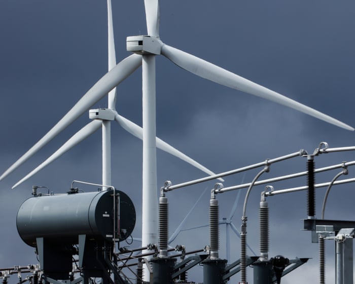
The 700 projects include wind and solar farms, battery storage, gas and hydro plans
More than half the renewable energy projects needed to meet the government’s clean power targets by 2030 are now able to plug into the electricity grid after years of delay, according to the system operator.
The National Energy System Operator (Neso) has offered more than 700 clean energy projects in Great Britain a grid connection date since the start of the year, after a two-year process to unblock a bottleneck that threatened to delay projects into the 2030s.
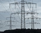
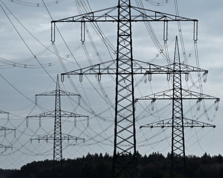
Government plan to de-link gas and electricity prices aims to reduce bills for consumers after global surge in prices
Households in England, Scotland and Wales could save nearly £200 a year on their energy bills if the government stepped into the market to act as the sole buyer of electricity, according to a thinktank.
The research found that public procurement of electricity, meaning the government would become the “single buyer” of power before it is resold to consumers, could shave billions of pounds from electricity prices.
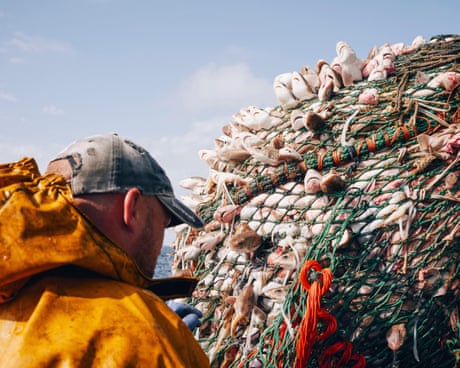
Conservationists say cherished creatures such as whales, dolphins and seabirds are being killed in large numbers by fishing tackle
Thousands of Britain’s most charismatic and protected marine wildlife, including whales, porpoises, dolphins, seals and seabirds are being killed as “collateral damage” by fishing vessels every year, according to the first-ever analysis of bycatch data.
The analysis, by the Wildlife and Countryside Link, a coalition of voluntary conservation groups, reveals the devastating toll bycatch, the accidental capture and killing of non-target species by fishing vessels, is having on marine species.
Targeted vaccination and improved testing planned as part of drive to eradicate disease by 2038
Cattle will be vaccinated against tuberculosis from 2030 as a “gamechanging” part of a new strategy to drive eradication of the disease in England by 2038. In parallel, the last badger culls are expected to end by 2029, with vaccination of badgers expanded.
More than 20,000 infected cattle are slaughtered each year, costing taxpayers £100m and inflicting a heavy toll on affected farmers’ livelihoods and mental health. Mass culling of badgers began in 2013 and has killed about 250,000 animals, at a cost of about £60m.