A Greek mother holding her baby. Credit: GR Archive
Greek women are having their first children later than ever. The average age of first-time mothers in Greece reached 31.2 years in 2024, according to new data from Eurostat. The figure places Greece well above the European Union average of 29.9 years and among the highest in the bloc.
That number marks a sharp climb over two decades. In 2001, the average age at which Greek women had their first child stood at 27.7 years. It crossed 30 for the first time in 2014. By 2021, it had surpassed 31. Since then, Greece’s first-time mothers have continued aging upward year by year.
The country’s standing in Europe reflects a broader pattern. Italy posted the highest first-birth age in the EU at 31.9 in 2024, followed by Luxembourg at 31.6 and Spain at 31.5.
Greece, at 31.2, sits alongside Ireland at the same level, within a cluster of countries where having a first child after 30 has become the standard.
First-time mothers in Greece having their firstborn at the age of 31
The age at all births, not just the first, has moved in the same direction. Greek women averaged 32.2 years at childbirth in 2024, up from 29.3 in 2001. Over those two decades, the average rose by nearly three years. The EU average for all births stood at 31.3 in 2024, placing Greece notably above it.
These numbers in Greece sit against a wider backdrop of declining fertility across Europe. The EU’s total fertility rate dropped to a record low of 1.34 live births per woman in 2024, down from 1.46 in 2022 and from 1.57 in 2008.
Eurostat notes that a rate of 2.1 is the level required to sustain a population without migration. A rate below 1.3 carries the label “lowest-low fertility.”
Greece remains among the EU countries yet to recover above that threshold, alongside Spain, Italy, Latvia, Lithuania, Luxembourg, Malta, Poland, Finland, and Estonia.
EU fertility hits record low, Greece still below threshold
The broader birth count tells the same story. The EU recorded 3.55 million births in 2024, compared to 6.8 million at the peak in 1964. That figure has fallen by roughly half over six decades.
For Greece, the Eurostat data makes the direction clear. Women in the country are becoming mothers for the first time at a later age than at any point on record, and the gap between Greece and the EU average continues to widen.
OpenAI files for IPO. Credit: Focal Foto / Wikimedia Commons / CC BY-SA 4.0
OpenAI confirmed Monday it has confidentially filed an IPO with U.S. regulators, joining rival Anthropic as the AI sector moves toward public markets. No timeline, share count, or pricing was announced.
The company said the move preserves the option for an earlier listing, while some decisions are easier to handle as a private firm.
Reuters reported OpenAI is targeting a valuation near $1 trillion for a debut possible as early as September. Anthropic filed for a U.S. IPO on June 1 after a $65 billion funding round valued it at $965 billion.
SpaceX is also pursuing a $75 billion offering at a $1.75 trillion valuation. Analysts say the simultaneous push by three major AI companies toward public markets is the most significant development of its kind for technology investors in a decade.
In March, OpenAI raised $122 billion from SoftBank, Amazon, and Nvidia at a valuation of $840 billion to $852 billion. ChatGPT had exceeded 900 million weekly active users and 50 million paying subscribers.
Monthly revenue stood at $2 billion, up from roughly $1 billion per quarter at the end of 2024, growing nearly four times faster than Alphabet and Meta at comparable stages. Internal projections put the company’s break-even point no earlier than 2030.
Beyond ChatGPT, OpenAI launched tools for government, healthcare, and finance, a web browser, consumer hardware plans, and an AI coding agent. It added a lower-cost $8 subscription tier and advertising as new revenue sources.
The Information reported in April that OpenAI projects 122 million subscribers this year and expects advertising to lead revenue by 2030.
A renegotiated Microsoft deal, covering $13 billion in investment since 2019, enabled growth at Azure and opened new agreements with Amazon and Alphabet.
OpenAI files its IPO amid legal battles and market pressure
Gil Luria of D.A. Davidson warned that large AI listings and Google’s recent secondary share sales could reduce the capital available for smaller offerings.
Michael Ashley Schulman of Cerity Partners said OpenAI appeared to be keeping its options flexible while Anthropic moved ahead in the IPO filing process. Prediction markets had expected OpenAI to file first.
OpenAI began as a nonprofit in 2015 and later added a for-profit arm under nonprofit oversight, a structure that drew attention when CEO Sam Altman was ousted by its board and reinstated within days in late 2023.
The company announced plans to convert to a public benefit corporation in December 2024. Early backer Musk filed a lawsuit alleging Altman and others redirected the organization from its founding mission for personal benefit.
A jury ruled against Musk in May, removing what analysts described as a significant legal obstacle ahead of the OpenAI IPO filing. His attorneys plan to appeal. Separate lawsuits link ChatGPT to shootings and suicides, and public skepticism toward AI persists.
AI reconstruction of ancient Iberian people in the local community. Credit: GR Archive
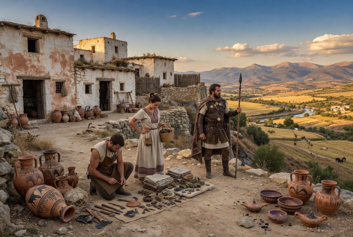
Ancient DNA from the bones of Iron Age Iberians shows that these people held onto their genetic roots despite centuries of Greek, Phoenician, and Carthaginian influence along the Mediterranean coast.
A study published in iScience traced genetic changes across northeastern Spain from 775 BC to 50 CE, marking the first time researchers have systematically analyzed Iberian communities from the early Iron Age all the way through Roman conquest.
Daniel R. Cuesta-Aguirre of the Faculty of Biosciences at Universitat Autònoma de Barcelona led the research. Because Iberian adults were cremated, their remains left no usable DNA.
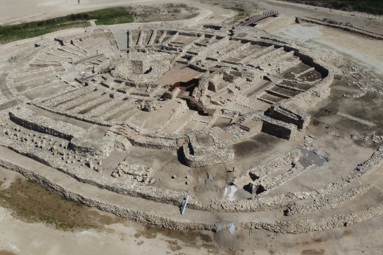
Researchers instead turned to newborn burials found beneath house floors and work areas at three sites: the Vilars fortress, Sant Miquel d’Olèrdola, and El Camp de les Lloses. Of 54 newborns examined, 22 yielded genome-wide data, and nine more contributed mitochondrial markers.
From fortress to Roman hub: three windows into the Iberian past
The three sites covered distinct phases of Iberian history. The Vilars fortress, home to the Ilergetae tribe, was occupied from the 8th to the 3rd century BC and captured the shift from pre-Iberian to full Iberian culture.
Sant Miquel d’Olèrdola, linked to the Cessetani tribe and active from the 4th to the 2nd century BC, reflected an established community with active trade connections.
El Camp de les Lloses, tied to the Ausetani tribe and dated from the late 2nd century BC to the 1st century CE, documented the period of growing Roman presence.
Genetic analysis placed most individuals from the Vilars fortress and Sant Miquel d’Olèrdola firmly within the local Bronze Age population. Their ancestry combined Western Hunter-Gatherers, Anatolian Neolithic farmers, and Steppe-related groups.
Steppe-related ancestry was somewhat higher in Iron Age individuals than in earlier Bronze Age populations from the same region, suggesting gradual internal shifts rather than large outside migrations.
Iberian DNA and Greek and Mediterranean influence
The DNA record of Iberians showed only limited traces of Greek and other Mediterranean genetic influence before Roman arrival. A few individuals carried ancestry linked to North Africa or southwestern Asia, but these were not widespread.
One newborn at Sant Miquel d’Olèrdola had a maternal lineage associated with North Africa. Researchers interpreted this as possibly reflecting a child born to a local parent and someone with Punic or Carthaginian ancestry, consistent with the large amounts of Punic pottery recovered at the same site.
The study also settled a long-standing archaeological debate. Two newborns at Sant Miquel d’Olèrdola, OLE04 and OLE06, were buried with their legs intermingled and no sediment between them, leading earlier researchers to believe they were twins.
DNA analysis proved they were completely unrelated and even carried different maternal haplogroups.
Roman military activity brought new genes to Iberian settlements
At El Camp de les Lloses, the pattern shifted noticeably. Five of the nine individuals showed clear genetic differences from earlier Iberian populations, carrying North African or Iranian Neolithic ancestry absent in previous generations.
Researchers connected this directly to Roman military and commercial activity, as the site served as a logistical hub tied to Roman infrastructure.
Taken together, the results point to a population that stayed genetically stable for centuries before Roman expansion fundamentally reshaped its makeup.
Majestic great white shark glides through the ocean waters. Credit: Elias Levy / OpenVerse / CC BY-2.0
Volunteer divers have recorded what researchers believe is the first footage of a great white shark filmed underwater in the Mediterranean, captured during a ghost net removal dive near a shipwreck in the Strait of Sicily.
Derk Remmers, a technical diver with Ghost Diving, was about 40 meters (131 feet) below the surface between Sicily and Tunisia when the shark appeared. He filmed the encounter. The footage and photographs were released on June 8 to mark World Oceans Day.
Remmers said that the odds of meeting such an animal underwater are far lower than winning the lottery, and that his hands were shaking as he filmed.
The shark circled the group, then turned and moved back toward the divers. Remmers said that its behavior appeared calm and curious, not aggressive. When the team released air from their regulators, the shark picked up speed and disappeared from view.
First great white shark sighting in the Mediterranean stuns researchers
Marine biologists who reviewed the footage called the sighting rare and scientifically significant.
Dr. Carlo Cattano, a researcher at the Sicily Marine Centre of the Stazione Zoologica Anton Dohrn, said that most knowledge of great white sharks in the region has come from dead animals caught accidentally in fishing nets, and that direct observations help researchers better understand the species.
A great white shark circled divers in the Mediterranean as they worked to pull deadly ghost nets from a shipwreck in the Strait of Sicily. pic.twitter.com/tdJKJ37TMY
— Tom Marvolo Riddle (@tom_riddle2025) June 9, 2026
He said that prior research had already identified the area as a key location for threatened species and that this sighting reinforces its conservation value. Researchers cautioned that broader conclusions would require further study.
The mission was organized by the Healthy Seas Foundation, along with Ghost Diving and the Society for the Documentation of Submerged Sites. The wreck’s location is being kept confidential.
Ghost nets, fishing gear lost or abandoned at sea, continue killing marine life long after leaving a vessel. Previous dives at the site documented loggerhead sea turtles and large fish species caught in the gear.
Shipwrecks attract marine life, and when ghost nets settle on them, those structures become underwater traps.
Ghost nets turn shipwreck ecosystems into ongoing ocean traps
Veronika Mikos, director of Healthy Seas, said that the sighting is a reminder of how much marine life still exists in offshore Mediterranean waters and how much is at risk from discarded gear and overfishing.
Remmers said that between 1% and 10% of all fishing gear worldwide is lost each year, possibly adding more than 500,000 metric tons of abandoned nets to the ocean annually.
He said that the shark’s presence near the wreck signals an abundance of prey, and that those same animals face entanglement risk. Volunteer cleanups alone cannot resolve the problem, he said, and stronger action against industrial and illegal fishing is needed.
The mission also included environmental DNA sampling and underwater monitoring. Healthy Seas said that it plans to release additional footage and scientific material in the coming weeks.
A federal judge ruled on Monday that the $100,000 fee Trump imposed on H-1B visa applications was unlawful, striking down one of the administration’s key immigration measures targeting skilled foreign workers.
U.S. District Judge Leo Sorokin of Boston found the payment was a tax, not a penalty, and that the president lacked authority to impose it without congressional approval. His 42-page ruling also barred the State Department and U.S. Citizenship and Immigration Services from enforcing the requirement.
Sorokin, appointed by former President Barack Obama, applied reasoning from a February Supreme Court decision that struck down Trump’s tariffs issued under emergency authority. He concluded that immigration law, like the emergency statute in that case, does not permit the president to levy taxes.
Inside Trump’s case for the $100,000 H-1B visa fee
The H-1B program allows U.S. companies to hire foreign workers for specialized roles. Applicants must hold at least a bachelor’s degree. Visas are approved for three years with a possible three-year extension.
Each year, the program makes 65,000 visa slots available, along with a separate pool of 20,000 set aside for applicants holding advanced degrees.
Trump's $100,000 H-1B visa fee has been blocked by a judge.
Judge Leo Sorokin ruled the new fee for highly skilled foreign workers is unlawful and that it amounts to an unauthorised tax. pic.twitter.com/v1J9Np5qyV
Employers typically paid $2,000 to $5,000 in fees before the order. Economists say the program helps American companies stay competitive and creates domestic jobs.
Trump announced the $100,000 H-1B visa requirement in September, saying the program had been misused to replace American workers with cheaper foreign labor.
The fee did not apply to foreign nationals already in the country on student visas, who represent a significant portion of new applicants.
The requirement saw little uptake. USCIS recorded only 85 payments as of Feb. 15, according to a March court filing.
Attorneys General celebrate as administration vows to appeal
Twenty Democratic attorneys general filed the lawsuit in December. California Attorney General Rob Bonta, who led the group, said that the ruling protects the country’s ability to attract skilled workers, on which the economy depends.
New York Attorney General Letitia James said that it blocked what she called an unlawful effort to undermine the program and the jobs it supports.
The administration defended the policy as a lawful use of presidential authority over immigration. White House spokeswoman Taylor Rogers said that the ruling would be appealed, adding that the president has the authority to restrict the entry of foreign nationals deemed harmful to American interests.
Justice Department spokeswoman Natalie Baldassarre said that the department would continue holding companies accountable for misusing the program.
At least three lawsuits have targeted the fee. A federal judge in Washington ruled in December in favor of the administration in a separate case brought by the U.S. Chamber of Commerce, which is appealing that outcome.
The administration has also called for stricter applicant screening and put forward a revised selection process designed to give priority to foreign workers with higher qualifications and better pay.
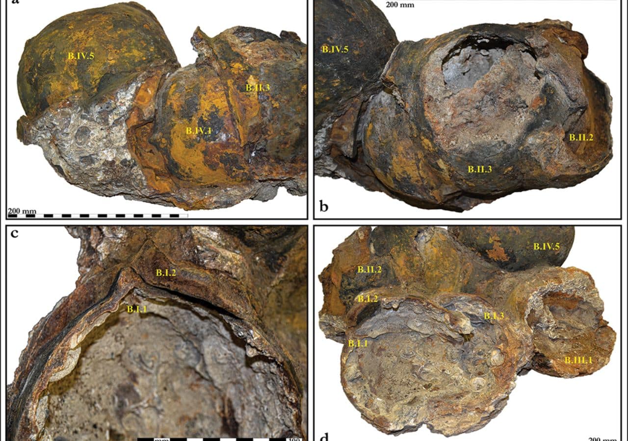
Researchers have confirmed that an underwater helmet hoard off Spain’s eastern coast near Benicarló is medieval rather than Ancient Roman as long assumed. The finding places the collection in the late 14th to early 15th century, during a period of intense maritime conflict along the Valencian coast.
The study was led by Manuel Frallicciardi, a doctoral student jointly supervised by the University of Alicante and the University of Salerno, and published in the journal Antiquity. It marks the first time radiocarbon dating has been applied to iron helmets from an underwater site.
Divers recovered the helmets in 1990 from Piedras de la Barbada, a submerged site about six meters (20 feet) deep near Benicarló in eastern Spain. At least forty-three helmets were identified. Split between two institutions, most of the helmets are stored at the Museu de Belles Arts de Castelló, while two conserved ones are on display at the Museo de la Ciudad de Benicarló.
Because the site had also yielded Roman-era artifacts, including ancient amphorae and Punic War-era bronze helmets, early researchers assumed the iron helmets belonged to the same ancient period.
Fabric linings within helmets unlocked dating mystery
Frallicciardi and his team found organic evidence trapped inside the helmets. Marine sediment had sealed fabric linings in place, protecting them from full decay. The fibers, identified as plant-based bast material in a plain tabby weave, were sent to the Beta Analytic laboratory in Miami and the Curt-Engelhorn-Zentrum Archaeometrie in Mannheim, Germany.
Four of the five radiocarbon results clustered between the last quarter of the 14th century and the early 15th century. One sample returned a date roughly 150 years later than the rest. Researchers linked this to post-depositional contamination. That helmet sat in a more exposed position, and microscopic analysis showed its fibers were more degraded, conditions that could allow younger carbon to infiltrate the sample.
Spain’s underwater helmet hoard links to medieval piracy era
The helmets fall into two types. Most have rounded skull caps with a central ridge, resembling simplified infantry helmets documented in medieval sources, including the Holkham Bible from around 1330 to 1340 and a fresco painted by Jacopo Uccello around 1378. One helmet has a six-panel faceted construction comparable to a kettle hat depicted in a 1437 altarpiece by Hans Multscher.
Frallicciardi noted the helmets predate the era when large Italian and German workshops standardized European armor production. Their simple construction points to smaller regional workshops supplying local infantry markets. The historical context strengthens that picture. From the 1370s onward, Islamic piracy along the Valencian coast intensified sharply, peaking in the final decades of the 14th century.
Communities responded by building coastal towers, fortifying settlements, and mobilizing local militias. Researchers believe the helmets were most likely lost at sea during this period of sustained maritime insecurity.
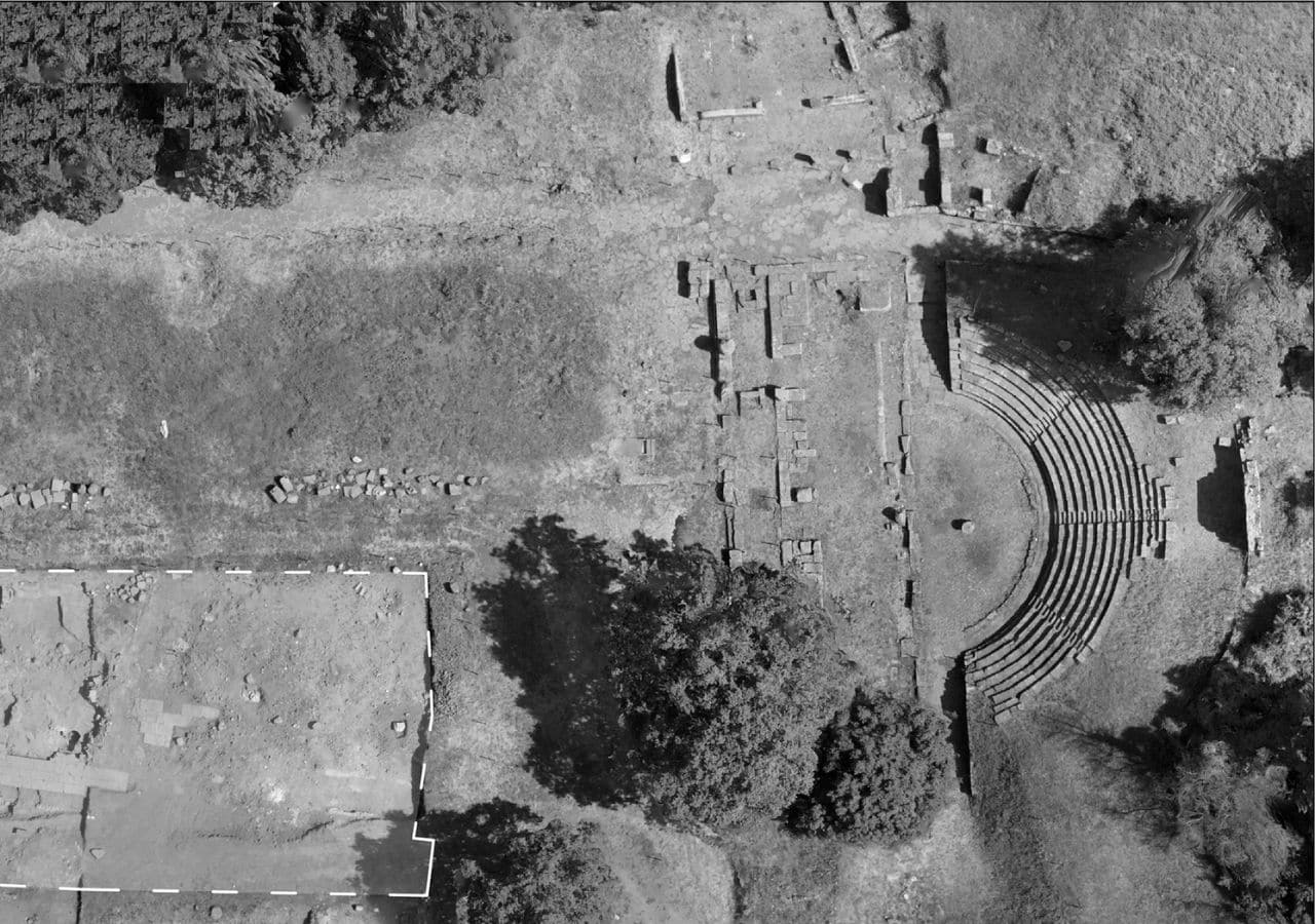
Archaeologists have uncovered the remains of a Roman basilica at Tusculum, an ancient city located about 30 kilometers (18.6 miles) from Rome, dating it back to the 2nd century B.C.
The discovery places the structure among the oldest known examples of Roman public basilica architecture, adding a significant piece to the puzzle of how Rome shaped its cities during the Republican era.
Researchers from the Spanish School of History and Archaeology in Rome, known as EEHAR-CSIC, made the find in the southern part of Tusculum’s forum. The forum served as the political and social heart of the city.
The basilica had remained hidden beneath later imperial-era structures for centuries. Antonio Pizzo, who leads the project, said the building is one of the earliest known examples of its type and joins a small, well-documented group of Republican basilicas.
Inside Tusculum’s ancient Roman basilica and its rare design
The structure measured 17.7 by 25.2 meters (58 by 82.7 feet). Its monumental facade featured a series of arches resting on nine flat pilasters, an architectural arrangement known as the “Theatermotiv.”
Pizzo noted that if researchers confirm this interpretation, it would mark the first time this design appears in Roman architecture. Until now, this style had only been identified in later, exceptional buildings such as the Tabularium in Rome.
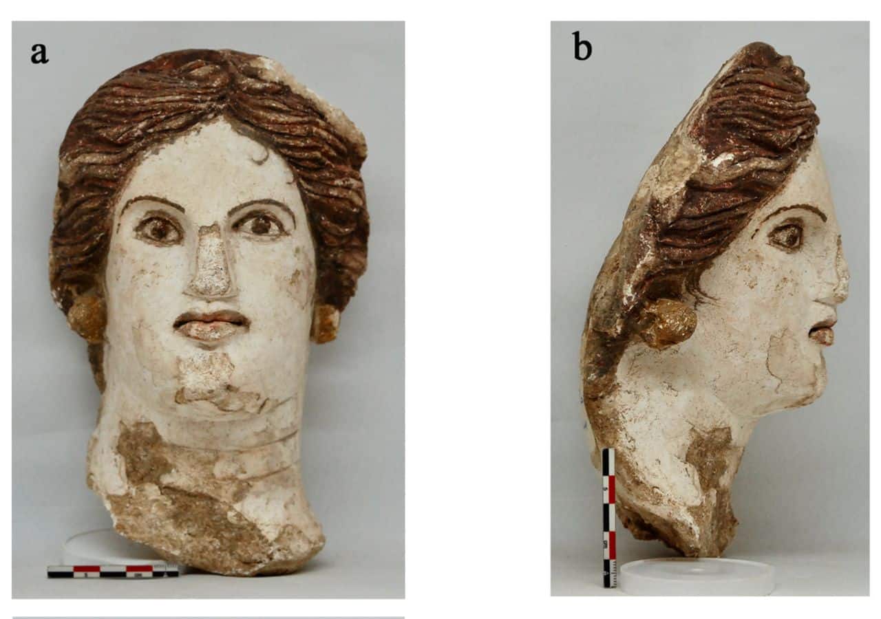
Among the most striking finds was a polychrome stucco capital discovered inside one of the building’s rooms. It depicts a female head rising from a cup of acanthus leaves, flanked by Ionic scrolls and floral motifs painted in white, red, and green.
The timing of the basilica’s construction aligns with the rise of powerful families from Tusculum, including the Mamilia, Fulvia, and Porcia clans.
The Porcia family produced Marcus Porcius Cato, famous for his repeated calls to destroy Carthage before the Third Punic War. Pizzo said these families drove a wave of monumental construction that went hand in hand with Rome’s growing power across the Mediterranean.
Powerful families and a Roman general add historical depth
Researchers also linked the site to Marcus Fulvius Nobilior, one of the most influential figures of the 2nd century B.C.
After defeating the Aetolian League in Greece, he returned to Rome with Hellenistic art and treasures. An inscription found at Tusculum confirms that some of that spoil went to his hometown.
Francesco De Stefano, co-author of the study published in the Journal of Roman Archaeology, said the discovery contributes valuable knowledge about the origins of this building type and key innovations in Roman public architecture.
The EEHAR-CSIC team has worked at Tusculum continuously since 1994, excavating its forum, theater, and baths. In 2023, they also uncovered a well-preserved marble female statue, with further details expected soon.
The ancient Greek Acropolises meant very different things to different people across history. A new study finds its symbolic meaning shifted dramatically over centuries, starting as a marker of civic pride and freedom before becoming firmly associated with tyranny and oppression.
Robin Rönnlund, an archaeologist at the University of Gothenburg in Sweden, published the study in the Annual of the British School at Athens. He examined ancient texts from Homer through the second century A.D. and traced how writers, philosophers, and inscription makers actually understood the word “acropolis” across roughly 1,000 years.
The research directly challenges a widely accepted scholarly narrative. For decades, historians described acropolises as prehistoric royal strongholds that were later abandoned and converted into either religious sanctuaries or civilian refuges during attacks.
Scholars built a false narrative around misread Aristotle
Rönnlund traces this narrative back to a misreading of a passage in Aristotle’s Politics, in which Aristotle theorized that acropolises suited oligarchies and monarchies.
Past scholars interpreted this theoretical statement as a historical sequence rather than a practical observation about fortifications, and the misreading quietly shaped academic thinking for generations.
Remains of the Temple of Artemis with the Acropolis. Credit: Carole Raddato / Wikimedia Commons / CC BY-SA 2.0
The word itself is also commonly misunderstood. Rönnlund explains “acropolis” does not mean “upper city,” as dictionaries suggest. It more precisely means “the farthest polis” or “the polis on the edge,” and it first appeared in the Odyssey in reference to Troy.
In early Greek poetry, the ancient Greek acropolis carried an unmistakably positive meaning. Simonides described the Acropolis as a symbol of Greek resistance to Persian invaders.
Ancient Greek Acropolis once stood for freedom and pride
Sparta was celebrated as the “acropolis of Greece” in the famous Lysander monument at Delphi. Philosophers extended the metaphor further. Plato called the head the “acropolis of the soul.”
Diocles of Karystos described the mind as a sacred statue placed on the acropolis of the body. These uses reflected strength, protection, and honor.
The meaning turned darker as foreign military occupation became widespread. Ancient sources contain 66 passages linking tyrants to acropolises. Plutarch recorded a warning that Caesar should not be established as “tyrant in the acropolis.”
Macedonian forces turned a civic symbol into oppression
After 322 B.C., Macedonian forces systematically garrisoned acropolises across Greece to keep conquered cities under control. Both Demosthenes and Isocrates described how garrisoned acropolises kept entire regions in submission.
Civilian populations almost never used acropolises as refuges, contrary to popular assumption. The sites lacked sufficient water and supplies for prolonged occupation, and literary sources confirm people typically fled to the walled city below or into the countryside during attacks.
Rönnlund reviewed 133 individual acropolises mentioned in ancient sources and calls for future research combining archaeology, epigraphy, and field surveys to properly reconstruct how these sites functioned in ancient Greek life.
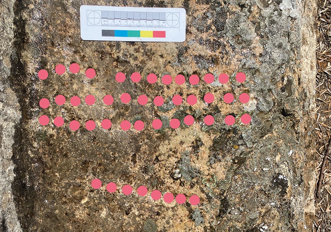
The gameboard in the hammam at Walīla, Morocco. Credit: Tim Penn / CC BY 4.0
A stone game board carved inside a medieval bathhouse in Morocco could rewrite what historians know about board games in early Islamic North Africa.
The discovery, published in the journal Libyan Studies, pushes back evidence for a game still played today by several centuries and sheds new light on social life in one of the region’s earliest Islamic settlements.
Tim Penn of the University of Reading led the study examining a previously unpublished game board at Walila, the site of ancient Roman Volubilis in Morocco. The board was carved into a stone step leading into a cold plunge pool inside a bathhouse, or “hammam,” built in the late eighth or early ninth century.
The structure was abandoned by the tenth or eleventh century. That narrow window gives researchers a rare, secure date for the board, something that is extremely difficult to establish for carved game boards found at ancient sites.
Morocco bathhouse yields a precisely dated medieval game board
The bathhouse was part of a larger complex that researchers believe served as the residence of Idrīs I, the founder of the Idrisid dynasty and one of the earliest Islamic rulers in North Africa.
Idrīs I arrived at Walila in 788 after fleeing the Hijaz and was declared imam by a local Berber tribe. The complex included a domestic building, a reception hall, and a storage compound, all built in a courtyard style more common to the Levant than North Africa.
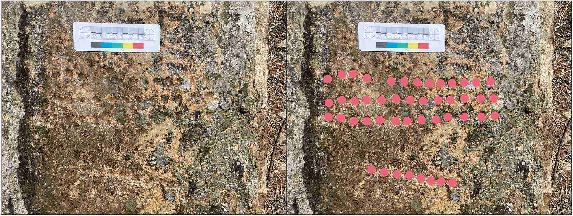
The game board itself measures roughly 34 by 9.5 centimeters (13.4 by 3.7 inches) and consists of three rows of at least 13 small, shallow holes carved into the stone.
The gameboard in the hammam at Walīla (left), with mark-up showing position of holes (right). Credit: Tim Penn / CC BY 4.0
Researchers identified it as most likely used for “tab/sig,” a running-fight game in which two players move pieces across the board from opposite sides, trying to capture each other’s pieces. The game is still played in parts of North Africa, the Middle East, and Turkey today.
Tab identified as Walila’s ancient running-fight game
The identification matters because the first known written reference to tab appears in the work of Egyptian author Ibn Daniyāl, who died in 1310.
The Walila board predates that reference by roughly 400 to 500 years, suggesting the game has a far longer history in the region than texts alone would indicate.
Researchers also ruled out mancala, another widely played ancient game, because the Walila board’s holes are too shallow and too small to hold multiple playing pieces, which mancala requires. The odd number of holes per row also makes the mancala rules impractical.
Similar boards from the early Islamic period have been found in Arabia, the Middle East, and Portugal, but none had previously been confirmed anywhere in North Africa.
The broad distribution of these boards across the early Islamic world, and as far as Scandinavia, where a closely related game called “daldos” or “sahkku” was played, points to the game traveling through trade and cultural networks.
From Arabian trade routes to Scandinavian shores
At Walila, those connections to the east are well documented. Imported coins, glassware, and a wine jar from Egypt and the Levant were all recovered at the site.
The bathhouse itself uses a dry-heat system more closely linked to Levantine construction than to the Roman bathing tradition, further reinforcing ties to the Middle East. Researchers suggest the game may have arrived in Morocco with Idrīs I or members of his entourage.
The board sat at the center of the steps into the plunge pool, fully visible to anyone in the changing room or entering the water. Researchers noted that its prominent placement suggests gaming was openly accepted as part of the social experience of bathing.
Bone dice recovered from nearby buildings at the site further confirm that a range of games, including games of chance, were played at Walila during the early medieval period.
The study calls on archaeologists working across North Africa and the broader Mediterranean to document game boards more systematically, noting that carvings of this kind are routinely left out of excavation reports.
Young students going home from school. Credit: GR Archive
Greece recorded one of the lowest rates of young people leaving education and training early in the European Union in 2025, ranking second among all 27 member states for keeping young people in education, according to new data from Eurostat.
The country posted a rate of 3.0%, trailing only Croatia, which reported the lowest share in the EU at 2.1%. Ireland placed third at 3.6%.
Greece’s standing reflects consistent progress over the past decade. In 2015, the country’s rate stood at 7.9%. Over ten years, it fell to 3.0%, a drop of nearly 5 percentage points.
Eurostat defines “early school leavers” as young people between the ages of 18 and 24 who exit education and training before completing upper secondary or higher-level studies. The data measures this group as a share of the total population in that age range.
Greece’s decade-long push keeps young people in education
The EU-wide average stood at 9.1% in 2025, just above the bloc’s own target of bringing that figure below 9.0% by 2030. The rate has declined steadily from 11.0% in 2015. Nineteen of the 27 EU member states reported a lower rate in 2025 compared to 2015, and 17 have already met the 2030 target.
In 2025, the share of early school leavers (young people aged 18-24 leaving early from education and training) in the EU was 9.1%.
Lowest shares in: Croatia (2.1%) Greece (3.0%)
Highest shares in: Romania (15.5%) Germany (13.1%)
Among countries that improved the most since 2015, Malta led with a drop of 7.7 percentage points. Portugal followed with a decrease of 7.4 percentage points, and Spain dropped by 7.2 percentage points.
Not all countries moved in the right direction. Seven EU member states reported higher rates in 2025 than in 2015. Cyprus saw the biggest rise, climbing 4.6 percentage points over the decade.
Germany increased by 3.0 percentage points, and Austria rose by 2.7 percentage points. Romania posted the highest rate in the EU in 2025 at 15.5%, followed by Germany at 13.1% and Spain at 12.8%.
Men across the EU still quit school earlier than women
A gap between men and women remained consistent across the EU. More young men left education early than women, though both groups showed improvement. The rate for men fell from 12.5% in 2015 to 10.6% in 2025. For women, the figure dropped from 9.4% to 7.5% over the same period.
Greece’s rate of retaining young people in education has improved in nearly every year over the past decade, placing it firmly among the EU’s strongest performers on this measure.
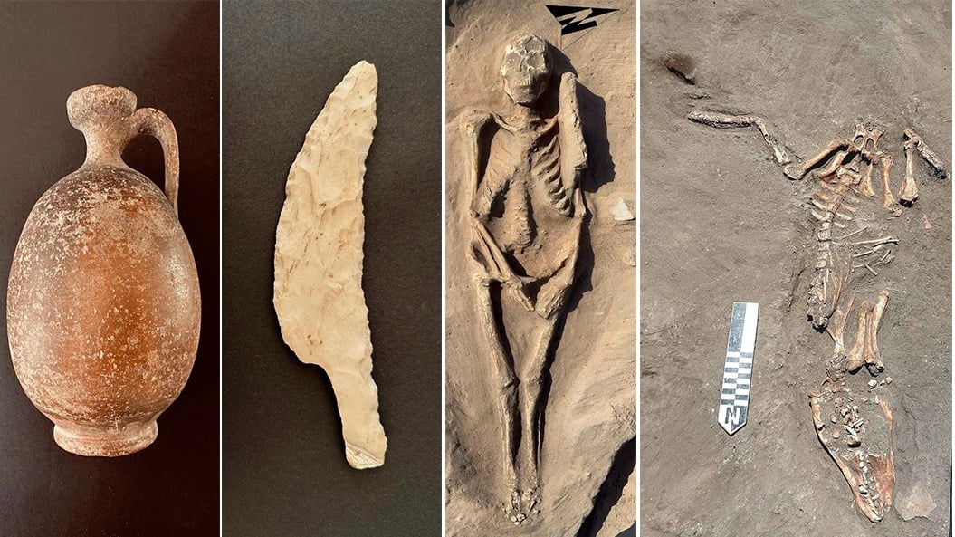
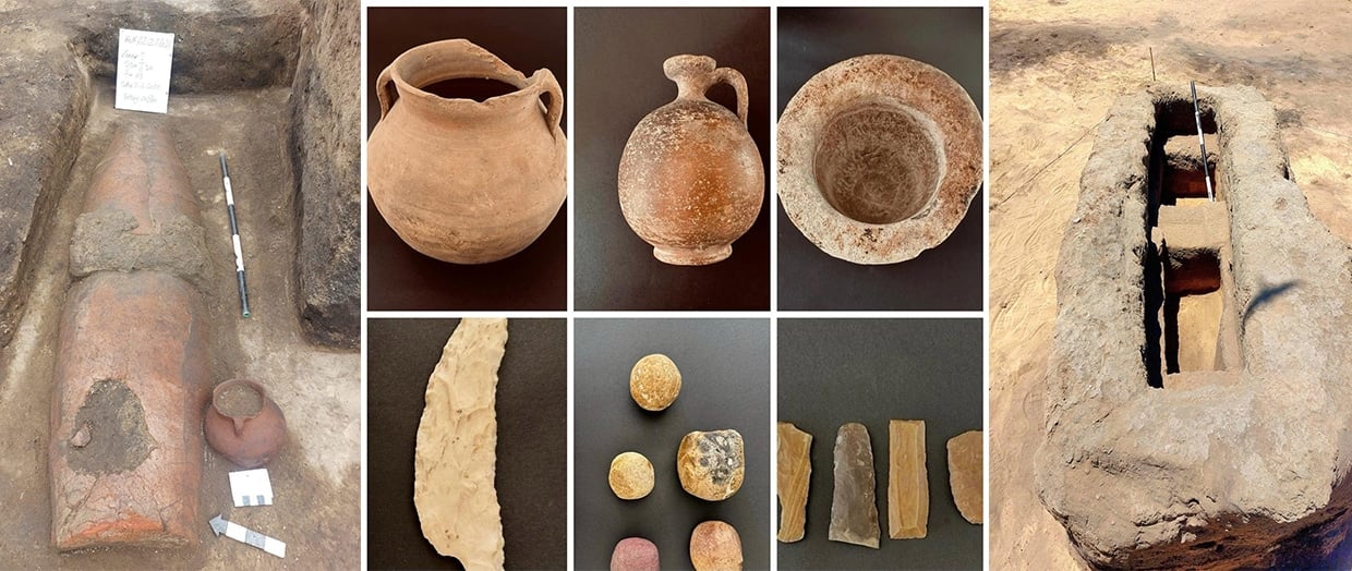
Egyptian archaeologists have uncovered part of an ancient cemetery from the Greco-Roman period at Tell Kom Aziza in Egypt’s Nile Delta, offering fresh insight into one of the region’s most historically layered sites. The site sits in Beheira Governorate and spans multiple historical periods stretching back thousands of years.
The Egyptian archaeological mission, working under the Supreme Council of Antiquities, found a wide range of burial types during excavations. Some bodies were placed directly in simple earth pits.
Others were buried in mud brick-framed pits, painted plaster coffins, or barrel-shaped pottery coffins. The barrel-shaped pottery coffin was among the most common burial types during the Ptolemaic era.
Tourism and Antiquities Minister Sherif Fathy said that the site holds value far beyond its burial remains. He described it as a window into settlement patterns, daily life, and how people interacted with their environment over millennia.
Burial diversity points to centuries of ritual evolution
Secretary-General of the Supreme Council of Antiquities Hisham El-Leithy said that early analysis of human remains pointed to a notable variety in burial practices. Some graves were individual, while others were collective.
Burial orientations ran along both north-south and east-west axes. Hand positions ranged from resting at the sides to the crossed-arms “Osirian” pose on the chest.
El-Leithy added that studying the archaeological layers confirmed the Greco-Roman cemetery was built over earlier settlement levels. Artifacts trace human activity at Tell Kom Aziza from the Old Kingdom through the New Kingdom, the Late Period, and into the Greek and Roman eras.
Mohamed Abdel Badie, head of the Egyptian Antiquities Sector, said that excavations produced a broad range of everyday artifacts. These included pottery and stone vessels, bread molds, multi-purpose stone tools, ovens, and storage jars.
Large quantities of fish, bird, and animal bones were also recovered, offering clues about the diet and daily habits of the site’s ancient residents.
Wild boar burials found at Egypt’s Greco-Roman cemetery
Among the more unusual finds, mission chief and Beheira Antiquities Director Khaled Abdel Ghani Farhat reported the discovery of complete wild boar burials within one of the archaeological layers.
He said that this is rare at ancient Egyptian funerary sites, given the pig’s symbolic association with the god Set. The find may suggest the boar played an economic or livelihood role at the site during a specific period of use.
Farhat said that the findings confirm Tell Kom Aziza is more than a burial ground. It is a detailed archaeological record of human life across successive historical eras. Further excavation seasons are expected to uncover more of what the site still holds.
An AI-colored reconstruction of an 18th-century depiction of pirate Henry Avery. Credit: GR Archive
Six shipwrecks linked to the real ‘Pirates of the Caribbean‘ have been found in Nassau’s harbor in the Bahamas for the first time, an international expedition announced.
The New Providence Pirates Expedition conducted the survey in late 2025 after receiving the first official permission to dive in the harbor’s restricted zone. Marine archaeologist Sean Kingsley and Michael Pateman, the Bahamas’ ambassador for history and culture, co-directed the project.
Three of the six wrecks are tied to the golden age of piracy, a period from the 1690s through the 1720s when Nassau served as a base for buccaneers, including Blackbeard, Henry Avery, Calico Jack Rackham, and Anne Bonny.
The standout find is a charred wooden hull fastened with wooden treenails, a method typical of 18th-century shipbuilding, burned down to the waterline. Pateman said that pirates burned seized ships after stripping them to remove evidence of their crimes.
Burned hull may belong to Avery’s missing pirate ship
Researchers believe the hull may be the Fancy, last commanded by Avery. In 1695, his crew seized gold, silver, sapphires, emeralds, and diamonds from Mughal Empire vessels, a haul worth around $150 million today.
The ship was never found afterward. The wreck fits the Fancy’s estimated age, size, and construction, though no formal identification has been made.
Pirates of the Caribbean shipwrecks found in the Bahamas for the first time reveal Nassau as history's most notorious golden age pirate port. pic.twitter.com/9WrS1pxMI1
— Tom Marvolo Riddle (@tom_riddle2025) June 5, 2026
A second site about 20 miles east of Nassau yielded iron cannons, 25 lead musket balls, a grinding stone for sharpening swords, and a swivel gun. Kingsley described swivel guns as pivot-mounted weapons pirates used to open fire on enemy crews at close range.
A third site under Nassau’s old bridge produced hull planks, rigging, wine bottles, wooden crates, and galley bricks. Nearby, researchers recovered 143 clay tobacco pipes marked with a horse, unicorn, crown, and the English royal crest.
The style suggests they were made in London around the 1740s. Kingsley said the cargo reflects Nassau settling back into regular trade after the pirate era closed.
Bahamas shipwrecks reveal the real ‘Pirates of the Caribbean’
The discoveries came despite significant disturbance to the harbor floor from years of dredging. Kingsley said the finds are likely only a fraction of what may remain and estimated that dozens more wrecks could be hidden in the harbor. The team plans to return using underwater drones but has found no evidence of treasure.
Until now, no shipwrecks connected to Caribbean pirates had been found in the Bahamas, even though Nassau served as the pirates’ primary base throughout that period.
The findings are featured in a documentary series, Mystery of the Pirate King’s Treasure, now on Wreckwatch TV, and in the latest issue of Wreckwatch magazine.
The skeleton of an equine at an ancient bread-making complex in Pompeii. Credit: Pompeii Archaeological Park
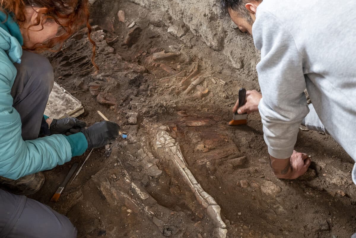
Archaeologists in Pompeii have uncovered an equine skeleton inside a bread-making workshop at one of the city’s most celebrated ancient complexes, opening a new chapter in the understanding of how humans and animals lived and worked together nearly 2,000 years ago.
The remains were discovered at the Insula of the Chaste Lovers, a large residential and commercial site renowned for its striking “chaste kiss” fresco, painted inside the dining room of the owner’s home.
The complex includes a working bakery, storage rooms, processing spaces, and the owner’s private residence. Researchers had previously found other equids at the site’s stables, where animals were used to power grain mills and transport the grain needed for bread production.
Pompeii’s chaste lovers complex was also a busy bakery
This latest skeleton was not found in the stables. Researchers found it in a separate room, suggesting the animal had fled there during the catastrophic eruption of Mount Vesuvius in 79 AD.
The excavation brought together archaeologists and specialists from the Applied Research Laboratory, including experts in animal remains, plant life, and human bones. This interdisciplinary approach has become one of the most important aspects of modern archaeological research at the site.
Archaeologists are excavating the skeleton of an equine. Credit: Pompeii Archaeological Park
Laboratory analysis is still ongoing. Researchers expect it to reveal more about the animal’s specific role in the production complex and the conditions it faced during the eruption.
The study could also contribute to a wider understanding of how animals responded to the disaster in real time, adding detail to the reconstruction of those final, chaotic hours.
Pompeii equine skeleton suggests a desperate Vesuvius escape
Gabriel Zuchtriegel, director of the Pompeii Archaeological Park, said that Pompeii offers far more than beautiful frescoes and ancient objects.
He said it gives researchers the opportunity to understand lives that were ended by the eruption, and that this extends to animals as well as people. The horse or donkey, he noted, was found inside a house with remarkable frescoes that also served as a working mill and bakery.
Its location in a room away from the stables points to an attempt to escape the eruption. Zuchtriegel called the excavation a strong example of the daily multidisciplinary collaboration at the site and said ongoing lab results will continue to offer significant scientific value.
Pompeii continues to yield new layers of ancient life. The site preserves not just objects and artwork but the full texture of daily existence, including the bonds between people, animals, and the spaces they shared.
The equine skeleton discovered in Pompeii’s ancient bread workshop is the latest reminder that the city still holds stories waiting to be told.
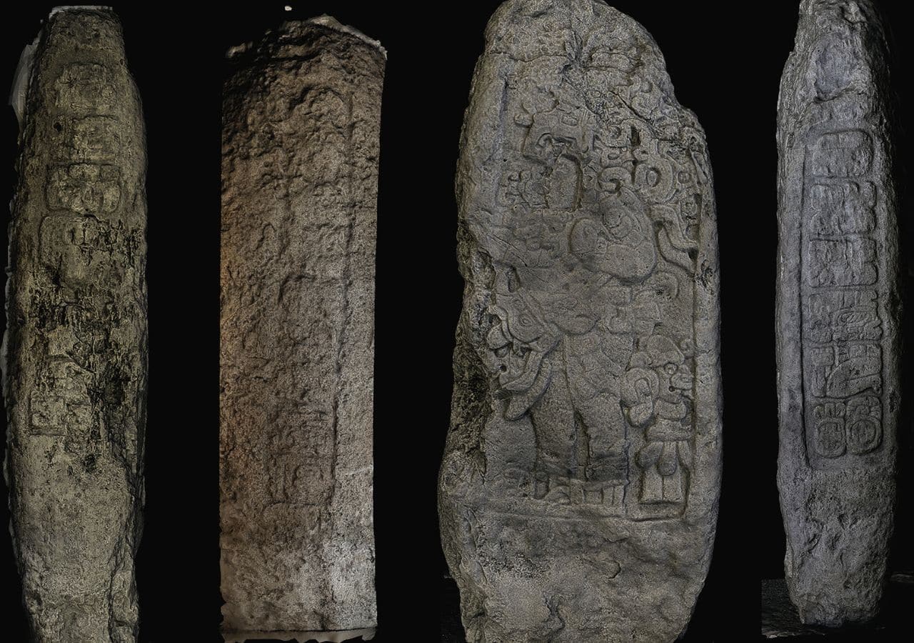
Archaeologists working at an ancient Maya site in southern Mexico have found what they say is the earliest known evidence of Maya kingship and calendar use in the region.
Kenichiro Tsukamoto, an archaeologist at the University of California, Riverside, led the study published in Ancient Mesoamerica. His team analyzed three stone monuments at El Palmar, a site in southeastern Campeche, Mexico.
One of them, Stela 46, carries an inscription dated to A.D. 180. That makes it the oldest confirmed “Long Count” calendar date discovered in the Maya Lowlands.
The Long Count is a dating system the ancient Maya used to record historical events in a fixed chronological order. Before this discovery, a stone monument at Tikal held that record with a date of A.D. 292. The El Palmar inscription predates it by 112 years.
Stone monuments link Maya kingship to an ancient calendar
What distinguishes Stela 46 from earlier finds is its direct connection to historical rulers and events. A king named Ajaw K’al Ubaah acceded to the throne in A.D. 131. Some 49 years later, in A.D. 180, he commissioned the stela as part of a royal ritual.
Alongside the Long Count, the inscription also incorporates the 260-day divinatory calendar, binding the royal event to a specific ceremonial date. No earlier Long Count inscription had ever been linked to a named ruler, the researchers said.
To read the heavily worn carvings, researchers combined traditional photography with photogrammetry and a high-resolution 3D scanner called Artec Spider II. The device captures detail as fine as 0.1 millimeters (0.0039 inches). It uncovered inscriptions that scholars had previously missed entirely.
The carvings also show that the king carried two royal titles, pointing to an already established order of royal authority at the site.
Monument traces El Palmar’s rulers back 17 generations
A second monument, Stela 20, strengthened the picture of Maya kingship at El Palmar. Its text identifies the ruler who commissioned it as the 17th king in a successive royal line.
Using the estimated average reign of 22.5 years for Classic Maya kings, the team calculated that the lineage’s first ruler likely rose to power between A.D. 102 and 154. That closely matches the accession date recorded on Stela 46.
A third monument, Stela 45, records the accession of a ruler named Tz’u Chak Ahk in A.D. 342. Together, the three stelae trace a royal dynasty from the second century A.D. to at least A.D. 884, one of the longest recorded among ancient Maya kingdoms.
Tsukamoto noted that El Palmar rose during a turbulent period. Several large Maya polities collapsed around A.D. 150 due to drought, soil erosion, and political instability. El Palmar appears to have grown as a new power center in their place.
The study concludes that calendar systems did more than track time. At El Palmar, they helped rulers legitimize and hold power for more than 700 years.
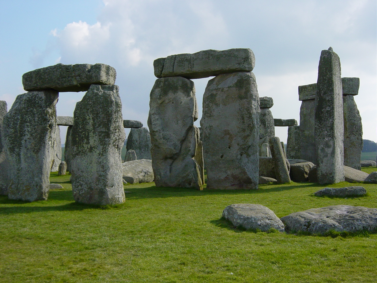
Stonehenge Altar Stone. Credit: Wikimedia Commons / Public Domain
The massive Altar Stone at Stonehenge may have received some help from ancient glaciers on its long journey to southern England, but people still likely carried it much of the remaining distance, according to new research.
The study, led by Anthony J. I. Clarke and published in the Journal of Quaternary Science, examined the possible origins and transport routes of the six-ton sandstone monument that sits at the center of Stonehenge.
Researchers have long believed the Altar Stone came from northeast Scotland, roughly 700 kilometers (435 miles) from Stonehenge. However, exactly where the stone originated and how it reached Salisbury Plain have remained major archaeological mysteries.
Searching for the stone’s birthplace
The team combined geological analysis with computer models of ancient ice sheet movements to investigate whether glaciers could have transported the stone southward during the last Ice Age. Scientists focused on the Orcadian Basin, a large geological region in northeast Scotland that has been proposed as the stone’s source.
How did a 6-ton stone reach Stonehenge from Scotland?
Researchers found that glaciers may have moved the monument's famous Altar Stone part of the way. But ancient people likely completed the final journey, hauling the massive rock hundreds of kilometers across Britain. pic.twitter.com/mQFbTIb3ve
— Tom Marvolo Riddle (@tom_riddle2025) June 4, 2026
The study compared the Altar Stone’s mineral signature with sandstone formations across the basin. Researchers looked specifically at the ages of zircon grains embedded in the rock. These grains act like geological fingerprints and can help identify where a stone was formed.
The results pointed most strongly toward Caithness in mainland northeast Scotland. Sandstones from that region showed the closest match to the Altar Stone’s zircon age patterns.
Ice movement presents a problem
Although Caithness appears to be the best geological match, computer models revealed a complication.
Ancient glaciers in the area mostly moved toward the northeast rather than toward southern England. The models showed only a limited pathway that could have carried material southeast toward Dogger Bank, a now-submerged area beneath the North Sea.
That finding makes a direct glacial journey to Stonehenge unlikely. Researchers concluded that glaciers alone could not explain how the stone reached its final location.
Human transport still likely
Even if glaciers carried the stone as far as Dogger Bank, people would still have needed to move it about 400 kilometers (250 miles) to Stonehenge.
The study also noted another challenge. Dogger Bank was flooded by rising sea levels after the Ice Age before the Altar Stone is thought to have arrived at Stonehenge. This creates a timing problem for any theory relying entirely on glacial transport. As a result, researchers suggest that ice may have played only an intermediate role in the stone’s journey.
The findings support the idea that Neolithic communities were responsible for moving the enormous stone over great distances. While glaciers may have shortened part of the route, substantial human effort would still have been required to bring the Altar Stone to Stonehenge, one of the world’s most famous prehistoric monuments.
The study adds a new piece to the puzzle of how ancient builders assembled Stonehenge and highlights the remarkable achievements of the people who constructed it thousands of years ago.
The dorsal surface of the pedipalp coxa. Credit: Richard J. Howard / CC BY 4.0
Fossil remains discovered in the United Kingdom have been confirmed as belonging to one of the largest scorpions ever known in Britain, researchers say. The giant species, Praearcturus gigas, measured more than 1 meter (3.3 feet) long and lived about 415 million years ago, making it one of the earliest large predators to inhabit land.
The findings resolve a long-running scientific debate over the identity of the animal. By reexamining fossil fragments from England and Wales, researchers confirmed that Praearcturus was a scorpion rather than a crustacean, as some scientists had previously believed.
With pincers measuring about 16 centimeters (6.3 inches) long, the giant arthropod would have dwarfed modern scorpions. Today, the largest living scorpion reaches only about 23 centimeters (9 inches) in length. The study was published in the journal Palaeontology.
A giant predator in a young world
When Praearcturus gigas lived during the Early Devonian Period, life on land was still developing. Small plants and fungi had begun spreading across the landscape, while arthropods were among the first animals to establish themselves away from water.
Researchers believe the giant scorpion preyed on smaller arthropods living on ancient floodplains. Its size likely made it one of the dominant predators of its time.
Pedipalp elements of Praearcturus gigas. Credit: Richard J. Howard / CC BY 4.0
Lead author Richie Howard said the discovery pushes back the appearance of giant arthropods by tens of millions of years. “When people think of giant arthropods, they often think of creatures such as Arthropleura or giant griffinflies,” Howard said. “But those animals appeared much later, after land ecosystems had become far more complex.”
Howard said the lack of large competing predators may have helped Praearcturus grow to such enormous proportions.
Solving a 150-year-old mystery
The fossil was first described in 1871 by British paleontologist Henry Woodward, who believed it belonged to a giant crustacean similar to a woodlouse.
For decades, scientists struggled to classify the animal because only fragments of its body had survived. The fossils lacked the distinctive tail that normally identifies a scorpion.
The mystery began to unravel after researchers compared the fossils with Eramoscorpius, a well-preserved ancient scorpion discovered in Canada. Both species share a distinctive triangular sternum on the underside of the body, providing strong evidence that Praearcturus was a true scorpion.
Clues to early life on land
The discovery offers new insight into a key stage of Earth’s history, when animals were adapting to life outside aquatic environments.
Researchers say Praearcturus may not have lived exclusively on land. Fossils from Wales preserve flap-like structures known as epimera, which resemble features seen in modern lobsters and crabs. These structures suggest the giant scorpion may have spent part of its life in water, where larger prey would have been available.
Co-author Greg Edgecombe said the species may even represent a lineage that returned to aquatic habitats after its ancestors adapted to life on land.
Scientists say additional fossil discoveries will be needed to determine how long Praearcturus survived and whether other fragmentary remains found in Britain belong to the species. For now, the fossils provide rare evidence of one of the largest scorpions ever to walk the Earth.
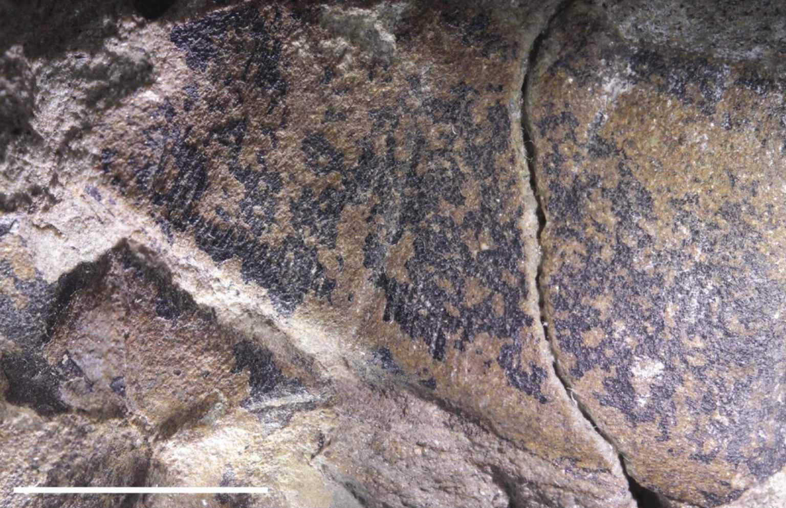
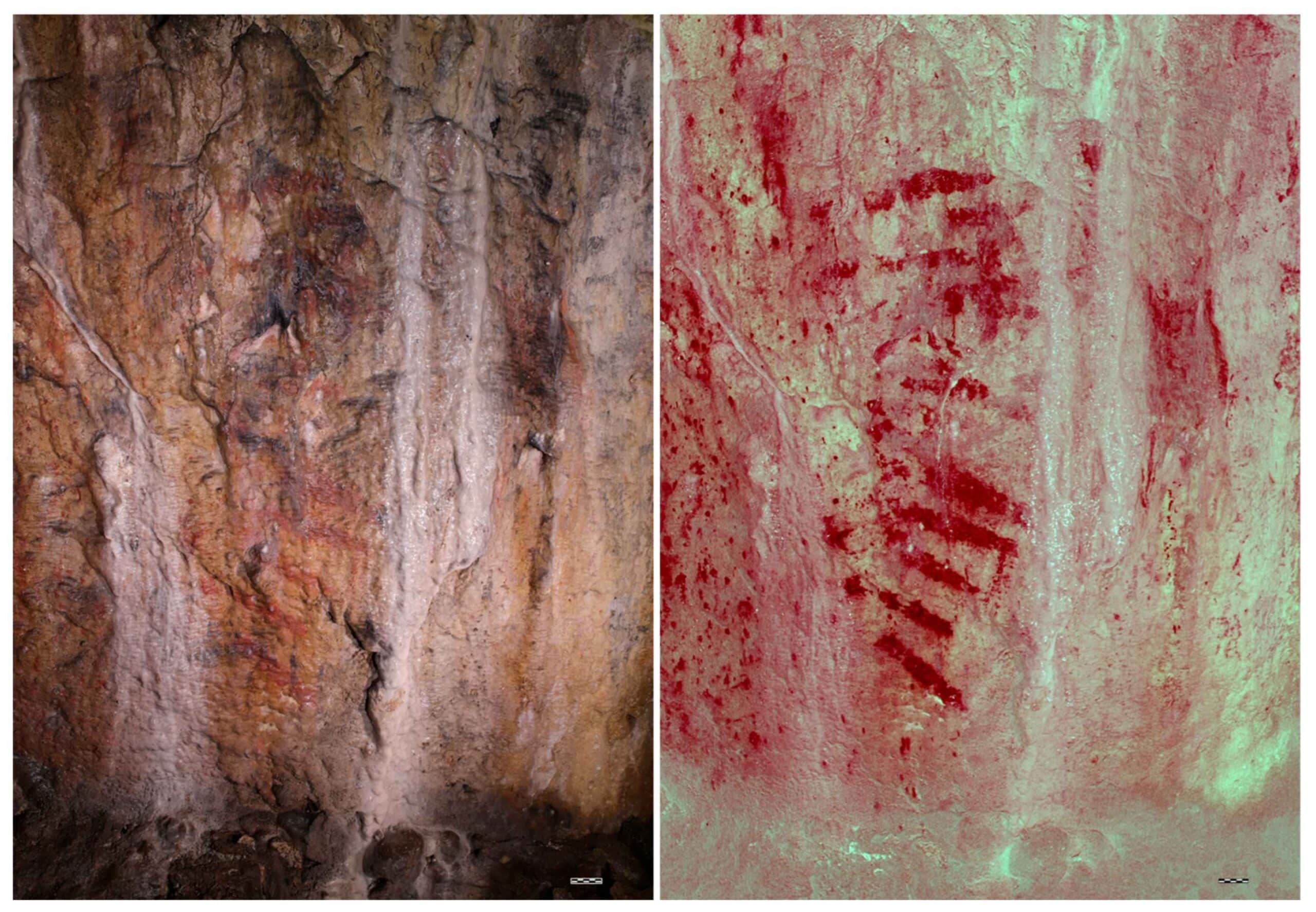
Red pigment markings at Bacon Hole Cave in Wales. Credit: George H. Nash / CC BY 4.0
A series of red markings inside a cave in south Wales has been confirmed as the UK oldest cave art, ending decades of debate over whether the images were created by humans or formed naturally.
Researchers determined that the markings at Bacon Hole Cave near Mumbles were painted about 17,100 years ago during the Upper Paleolithic period. The discovery makes them the oldest known rock art in Britain and northwestern Europe. The findings overturn a conclusion that had stood since 1928, when experts dismissed the markings as natural mineral stains rather than prehistoric artwork.
Discovery revisited after more than a century
The markings were first reported in 1912 by professors William Sollas and Henri Breuil, who identified the red bands as prehistoric cave paintings. At the time, the discovery was described as the first example of Paleolithic cave art found in Britain.
A substantial breccia deposit is located around the current entrance area of the cave. Credit: George H. Nash / CC BY 4.0
That interpretation was later rejected. Researchers concluded that the red streaks were caused by iron-rich minerals seeping through the limestone walls, and the site gradually lost its significance as a prehistoric art location.
More than a century later, an international team led by prehistoric art specialist George Nash reexamined the markings using scientific methods unavailable to earlier researchers. The team’s findings, published in the journal Quaternary, confirmed that the red pigment was intentionally applied by humans around 17,100 years ago.
Scientific analysis confirms human origin
Researchers used uranium-thorium dating and archaeometric analysis to study the pigment and surrounding cave deposits. Laboratory tests identified a mixture of calcite and clay residues within the paint, indicating that the material had been deliberately prepared. Analysis also showed that the pigment was applied directly with a finger.
The painted lines appear as evenly spaced horizontal bands arranged in a structured pattern. Researchers said the design is inconsistent with natural geological processes and supports the interpretation originally proposed in 1912.
Part of the artwork may have been overlooked for decades because a local fisherman painted graffiti on a nearby section of the cave chamber in 1894, making the markings more difficult to interpret.
Life in Wales during the Ice Age
Eastern view of the cave entrance and the Bristol Channel. Credit: George H. Nash / CC BY 4.0
The artwork was created as Wales emerged from one of the coldest phases of the last Ice Age, known as the Devensian glaciation. At the time, the landscape around Bacon Hole was a cold, largely treeless environment. Researchers believe the area surrounding what is now the Bristol Channel attracted large grazing animals during seasonal migrations.
The cave and other nearby shelters along the Gower coastline would have provided suitable living spaces for hunter-gatherer groups moving through the region.
A significant addition to Britain’s prehistoric record
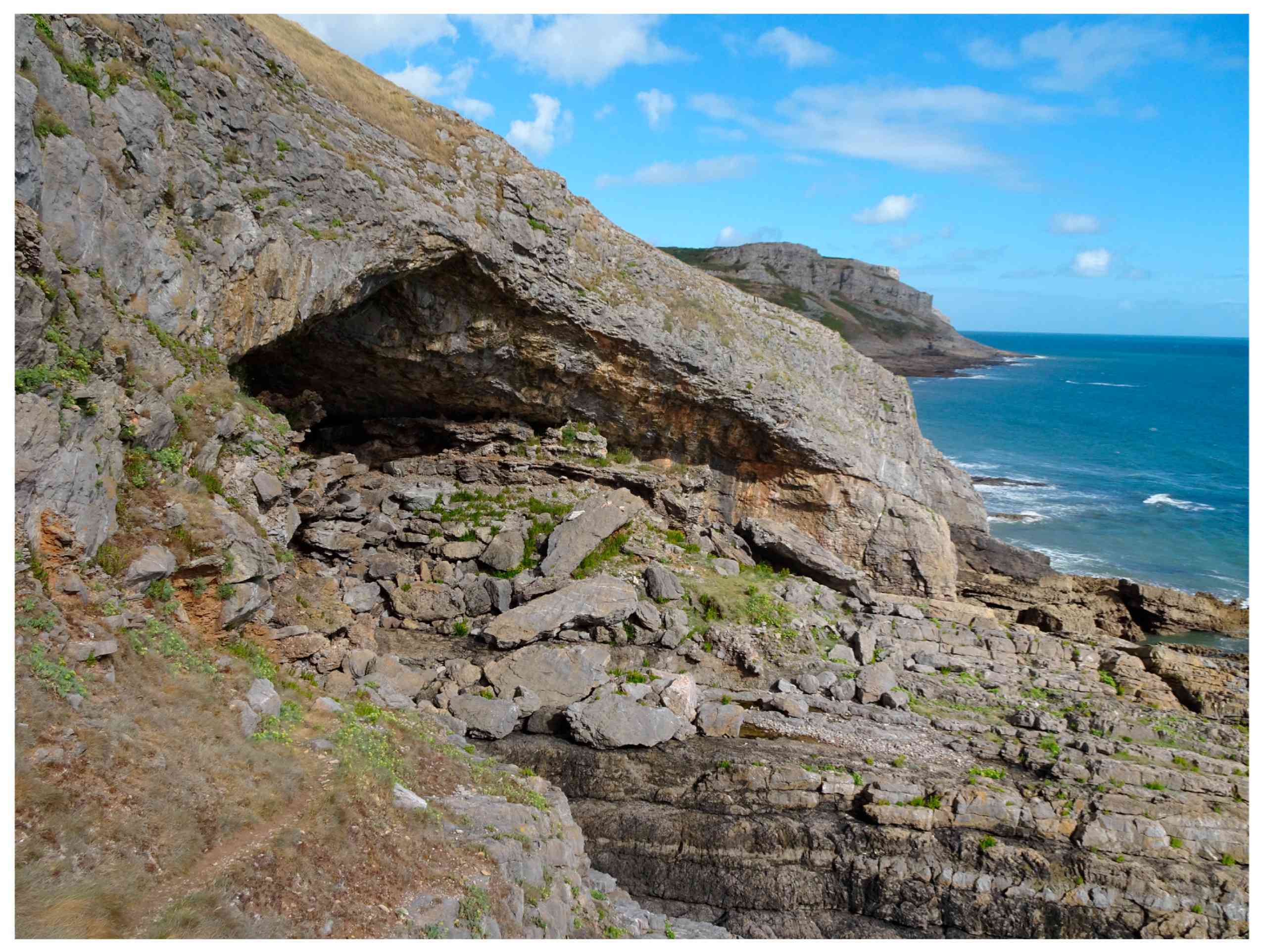
Bacon Hole Cave lies within the limestone cliffs of the Gower Peninsula overlooking the Bristol Channel. Although the area is recognized for its natural beauty, the cave is not currently protected as a scheduled monument.
Researchers argue that the site’s newly confirmed status as the UK oldest cave art strengthens the case for greater protection. The study was conducted by researchers from First Art, the University of Southampton, Swansea University and other institutions, with support from the National Trust and the Bradshaw Foundation.
The discovery adds to a small number of known examples of Upper Paleolithic rock art in Britain and provides rare evidence of artistic activity in the region more than 17,000 years ago.
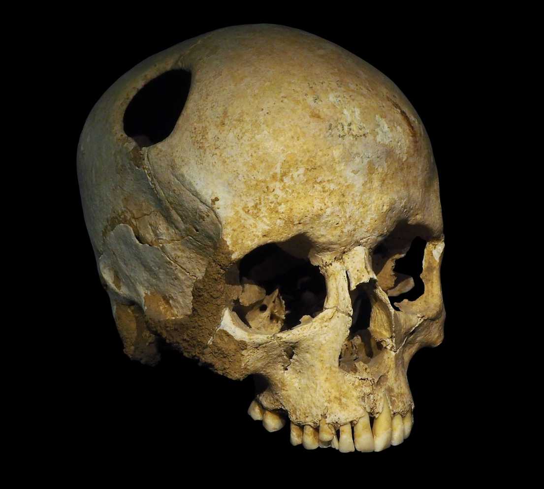
A 4,000-year-old child’s skull discovered in Uzbekistan is offering rare evidence of one of the oldest known surgery in Asia, shedding new light on medical knowledge in the Bronze Age.
The remains belonged to a child who died at about 5 years old. Researchers found clear signs of cranial trepanation, a procedure that involved cutting or drilling into the skull. The discovery represents the oldest documented evidence of surgery in Central Asia and one of the oldest known examples anywhere in Asia.
A joint team of Italian and Uzbek researchers uncovered the skeleton during excavations in the Northern Bactria region of southern Uzbekistan, near the border with Afghanistan.
Evidence of a complex procedure
Archaeologists found the child buried in a single grave alongside another child who died at about 3 years old. Examination of the older child’s skull revealed distinct traces of trepanation that researchers believe were made using stone or bone tools.
Trepanation is among the oldest surgical procedures known to humanity. Archaeologists have documented similar operations in ancient societies across Europe, Africa and Asia. The practice may have been used to treat head injuries, epilepsy, severe headaches or other medical conditions. In some cultures, it may also have served ritual or spiritual purposes.
A 4,000-year-old child’s skull discovered in Uzbekistan contains evidence of cranial trepanation, making it the oldest documented surgery in Central Asia and one of the earliest known in Asia. pic.twitter.com/w1NDyBNpEV
— Tom Marvolo Riddle (@tom_riddle2025) June 3, 2026
Researchers noted that medicine and religion were often closely connected in ancient societies, making it difficult to determine the exact reason for the operation.
The findings also raise questions about the level of medical expertise that existed in Central Asia thousands of years ago. Performing such a procedure would have required specialized knowledge of the human body and considerable technical skill.
A window into the Oxus civilization
The burial was discovered at the prehistoric settlement of Djarkutan, one of the most important urban centers of the Oxus civilization. Researchers dated the grave to the late third millennium B.C.
Also known as the Bactria-Margiana Archaeological Complex, or BMAC, the Oxus civilization flourished across parts of modern-day Uzbekistan, Turkmenistan and Afghanistan between about 2500 and 1500 B.C. The culture is known for its advanced agriculture, urban development and rich material traditions.
Researchers began a broader project to investigate Djarkutan and other aspects of the Oxus civilization in 2024. “Djarkutan continues to surprise us,” excavation director Enrico Ascalone said in a statement. “A cranial trepanation on a child, four thousand years ago, in Central Asia: until yesterday it was unthinkable. Today it is in our data.”
Questions remain unanswered
The discovery has also created new mysteries. Researchers are now investigating who may have performed the operation, what medical knowledge was available at the time and why such a procedure was carried out on a young child.
Evidence of ancient trepanation is relatively common in some parts of the world, but cases involving children of this age remain rare. Further analysis may help researchers understand whether the operation was intended to treat an illness, respond to an injury or fulfill a ritual purpose.
For now, the skull offers a remarkable glimpse into the medical practices, beliefs and capabilities of a Bronze Age civilization that thrived in Central Asia four millennia ago.
Mayan ball court in Campeche. Credit: Tracy Uselton. CC BY 2.0/flickr
Archaeologists studying the Maya Belize region have identified a large network of ancient ballcourts, including many previously unknown structures, offering new insights into how Maya communities organized public life, ceremonies and political activity.
The discoveries come from a study published in Latin American Antiquity and led by Mara De Gregori. Researchers used airborne lidar technology to examine a large area in northwestern Belize. The survey revealed dozens of ballcourts across the southeastern Three Rivers region, dramatically expanding what archaeologists know about the distribution of these important ceremonial spaces.
Ballcourts were among the most recognizable features of ancient Maya cities. The ballgame was more than a sport. It combined ritual, politics and public gatherings, making it a central part of Maya society. Archaeologists have long viewed ballcourts as places where communities came together and where leaders displayed power and reinforced social ties.
Lidar uncovers hidden architecture
Before the recent lidar survey, only a handful of ballcourts had been documented in the southeastern Three Rivers region. The new research identified many additional examples, increasing the known total to 26 ballcourts. The findings suggest the area was far more interconnected and active than previously believed.
Lidar, which uses laser pulses to map landscapes beneath dense vegetation, allowed researchers to detect architectural features hidden under forest cover. The technology has transformed Maya archaeology in recent years by revealing roads, buildings and entire settlements that were previously invisible from the ground.
Ballcourts served as public gathering spaces
The study found that most of the newly documented ballcourts were located within civic and ceremonial centers. Many were positioned near plazas, processional routes and other public spaces, indicating that they played a major role in community events and religious activities.
A new lidar survey in Belize has uncovered a much larger network of Maya ballcourts than previously known, including many identified for the first time. pic.twitter.com/7BlkESLcRS
— Tom Marvolo Riddle (@tom_riddle2025) June 2, 2026
Researchers found that 19 of the 26 ballcourts followed an open-ended design, making it the most common architectural style in the region. Most were also freestanding structures rather than being attached to larger buildings. These patterns suggest that local builders followed widely shared Maya architectural traditions while adapting them to local needs.
The survey also uncovered evidence that some ballcourts were located outside major centers. Although rare, these rural examples indicate that ballgame-related activities extended beyond large urban settlements and may have reached smaller communities across the landscape.
Evidence points to ceremonies and feasting
Excavations at one site, Ayiin Winik, provided additional clues about how these spaces were used. Researchers found elevated phosphorus levels around the ballcourts, a sign often linked to food preparation and human activity.
Nearby deposits contained serving vessels, food-processing tools and ritual objects, including drum fragments and a serpentine celt. The evidence suggests that communal gatherings, feasting and ceremonies likely accompanied ballgame events and processions.
These findings support long-standing views that Maya ballcourts were not simply sports venues. They also functioned as important social and ceremonial centers where communities gathered for public events.
Regional patterns emerge
The study examined the size, layout and orientation of the structures. Most ballcourts were aligned roughly north to south, matching patterns seen across the Maya lowlands. Researchers believe this orientation reflects broader cultural traditions shared throughout the region.
The majority of the courts also displayed similar dimensions. Alley lengths generally ranged from about 10.5 to 20.5 meters, although a few larger examples stood out. Mound sizes were also relatively consistent across the region.
Local traditions shaped court design
Researchers compared the southeastern Three Rivers ballcourts with examples from neighboring Maya regions, including the Belize River Valley and Holmul area.
The analysis revealed both similarities and differences. Alley lengths and mound dimensions were largely consistent across regions, suggesting common architectural standards. However, alley widths showed clearer regional variation.
Ballcourts in the southeastern Three Rivers region tended to have wider playing alleys than those in several neighboring areas. Researchers also found that only this region showed a strong relationship between alley length and width, indicating a more deliberate approach to proportional design.
According to the study, these results suggest that Maya communities followed a shared architectural blueprint while adapting certain features to local traditions and preferences.
The findings also demonstrate how lidar technology continues to reshape archaeological research. By revealing structures hidden beneath dense forests, the technology is helping researchers build a more complete picture of social, political and ceremonial life in the ancient Maya world.
Photo of glyphs in question on the monolith. Credit: John Justeson et al. / CC BY 4.0
Ancient Zapotec inscriptions carved at Monte Albán in southern Mexico may contain the oldest known record of a lunar calendar in the Americas, according to new research that sheds light on how one of Mesoamerica’s earliest civilizations tracked time more than 2,000 years ago.
The study, published in Latin American Antiquity, found that a recurring symbol in Zapotec inscriptions recorded the number of days since the first visible crescent moon after a new moon. The discovery pushes evidence for lunar day counts back to at least the fifth century BCE, centuries earlier than previously documented examples elsewhere in Mesoamerica.
Researchers led by John Justeson analyzed inscriptions from Monte Albán, the ancient Zapotec capital in present-day Oaxaca. They focused on a symbol known as “Glyph W,” which appears alongside dates recorded in the region’s complex calendrical system.
Searching for the meaning of Glyph W
For decades, scholars debated the meaning of Glyph W. Some suggested it marked a day within a month or identified a position within a ceremonial calendar. However, none of those explanations consistently matched the inscriptions.
The new study argues that the symbol instead recorded a lunar day count. In practical terms, it indicated how many evenings had passed since the first appearance of the moon’s crescent following a new moon.
Researchers examined seven well-preserved inscriptions that contained both Glyph W and dates tied to the Mesoamerican 52-year calendar cycle. By comparing the intervals between these recorded events and matching them with known lunar cycles, they identified a pattern that closely aligns with the moon’s average 29.5-day cycle.
Evidence of a lunar day count
Inscriptions from Monte Alban, usable for the calibration of the Glyph W cycle. Credit: John Justeson et al. / CC BY 4.0
The analysis revealed that the recorded dates could fit seven possible placements in absolute time between about 650 BCE and 50 BCE. Only one of those placements also matched features of the Zapotec calendar documented centuries later during the colonial period. That chronology places the inscriptions between roughly 496 BCE and 221 BCE.
The findings suggest that Zapotec astronomers carefully monitored the moon and incorporated those observations into their written records. Researchers say the system resembles later Maya lunar counts, which became widespread many centuries afterward.
How the Zapotec tracked time
The discovery is significant because Monte Albán preserves the earliest large body of hieroglyphic writing known from Mesoamerica. The inscriptions provide a rare glimpse into how early societies organized time, recorded historical events and connected celestial observations to religious and political life.
Researchers also found evidence that the Zapotec divinatory calendar likely changed dates around midday rather than at midnight. Historical records from the 16th century describe a similar practice among Zapotec communities.
According to the study, one inscription appears to document a ceremony linked to the return of a “year-bearer,” a special calendar date associated with the beginning of the year. Researchers concluded that the event was probably celebrated in the afternoon by at least 222 BCE.
Clues from the moon’s first appearance
The study relied on a combination of epigraphy, archaeology, linguistics and astronomy. Researchers reconstructed ancient lunar visibility at Monte Albán by modeling when the moon’s crescent would first have been visible from the site’s elevated position overlooking the Oaxaca Valley.
They then compared those observations with the dates recorded in the inscriptions. Thousands of possible chronological combinations were tested before researchers narrowed the results to a handful of viable solutions.
Rewriting the history of Mesoamerican astronomy
The work also challenges earlier interpretations of Glyph W that had remained influential for decades. Researchers found that previous theories failed to explain several complete inscriptions and produced inconsistencies when compared with known calendar patterns.
Beyond solving the mystery of a single symbol, the findings provide new evidence that sophisticated astronomical observation was already embedded in Zapotec society during the first millennium BCE.
Researchers say the inscriptions demonstrate that lunar day counts were used in Mesoamerica about 857 years earlier than previously known. The discovery highlights the scientific and intellectual achievements of the Zapotec civilization and offers a deeper understanding of how ancient peoples observed the sky and organized their world around celestial cycles.

https://t.co/UXznIQAcaV pic.twitter.com/KZLowpImTu


 Croatia (2.1%)
 Greece (3.0%)
 Romania (15.5%)
 Germany (13.1%)


_02.jpg)