Dwarf elephants once inhabited the Aegean Islands and influenced Mycenaean culture through the use of their fossil remains. Credit: Ninjatacoshel, Wikimedia Commons, CC-BY-SA 3.0
The dwarf elephants of the Aegean Islands represent a fascinating intersection of paleontology, archaeology, and environmental history, yet their significance during the Mycenaean period remains insufficiently explored.
These now-extinct, insular-adapted elephants provide a critical look into evolutionary biology and human-environment interaction in Bronze Age Greece.
Insular dwarfism: Evolutionary mechanisms and island biogeography
Dwarf elephants of the Aegean, such as Elephas creticus on Crete and Palaeoloxodon tiliensis on Tilos, exemplify insular dwarfism, an adaptive response to island isolation characterized by limited resources, absence of large predators, and ecological shifts.
Morphometric analyses of fossilized remains at the Department of Genetics, Evolution and Environment of the University College of London demonstrate a marked reduction in body size, skeletal robustness, and changes in dentition compared to mainland proboscideans.
These evolutionary modifications likely occurred over tens of thousands of years, culminating well before the Mycenaean era, with the last populations vanishing at the close of the Pleistocene or early Holocene. The islands’ geographical isolation, combined with fluctuating sea levels and climatic conditions, further influenced the survival and adaptation of these populations.
Archaeological correlations: Mycenaean awareness and utilization
Mycenaean Boar’s tusk helmet, similar to the one worn by Odysseus in Homer’s account. Credit: Wikimedia Commons, Doreio, CC-BY-3.0
A probable descendant of the large straight-tusked elephant (Palaeoloxodon antiquus), scholar George Theodorou claimed it walked the Earth as recently as 3,500 years ago. This is based on preliminary radiocarbon dating completed in the 1970s, which would make it the youngest surviving dwarf elephant as well as elephant in general in Europe.
Archaeological evidence suggests that Mycenaean societies were aware of—and possibly exploited—remnants of these creatures. Elephant molars and teeth, discovered in Mycenaean contexts across mainland Greece and the islands, appear to have been repurposed as raw materials for crafting tools, ornaments, or ritual objects.
The provenance of these elephant teeth is debated. They may have been derived from fossilized remains of dwarf elephants embedded in island deposits. The Mycenaeans scavenged these for durable ivory-like materials. The studies of Mycenaean artifacts employing elephant ivory or tooth, for instance, demonstrate distinct wear patterns and sourcing signatures, implying a sophisticated interaction with paleontological resources.
In an early form of “cultural paleontology,” this is evidence that megafauna contributed materially and symbolically to Bronze Age material culture. However it’s not unreasonable to suggest that the Mycenaeans may have seen living dwarf elephants, especially on remote islands such as Tilos.
Even if rare, their presence could explain the cultural reuse of elephant teeth—not just as fossil curiosities,but as materials from an animal still within human memory or possibly even within living contact. Such use is also indicative of a level of knowledge or at least recognition of these animals’ past presence, perhaps integrated into local lore or ritual symbolism.
Fossil of the extinct Palaeoloxodon creutzburgi species that subsisted on the island of Crete. Credit: G.M. Woodward, Wikimedia Commons, Public Domain.
Ecological impact and anthropogenic factors in extinction
The extinction of dwarf elephants in the Aegean is often attributed primarily to natural climatic shifts. Sea-level changes following the last Ice Age also had a significant impact. However, the intensification of human activity during the Neolithic through Mycenaean periods likely accelerated their disappearance.
Deforestation, habitat fragmentation, and hunting pressure from early agricultural communities would have placed additional stress on already vulnerable island populations. Analyzing sediment cores and pollen records in conjunction with archaeological site data indicates significant environmental transformations. These coincide with the expansion of Mycenaean influence.
Although most dwarf elephant species went extinct well before the Mycenaean period (ca. 1600–1100 BC), there is credible evidence that some may have survived into that time, potentially overlapping with early Mycenaean society.
Analytical implications: Reassessing Mycenaean interaction with prehistoric fauna
The presence of elephant teeth in Mycenaean material culture challenges traditional dichotomies separating natural history from human history. It invites reconsideration of this society’s environmental perception. Mycenaeans were not merely exploiters of living fauna but also curators of a landscape layered with prehistoric memory.
Further multidisciplinary research combining paleontology, archaeozoology, and geochemical sourcing is necessary to clarify the extent and nature of Mycenaean engagement with these extinct species. The analysis of wear patterns, isotopic signatures, and contextual associations of elephantine artifacts can yield insights into trade networks, symbolic systems, and resource utilization strategies.
Moreover, integrating the study of dwarf elephants into the broader narrative of Mycenaean civilization enriches understanding of how ancient societies conceptualized and incorporated their environmental heritage. It reveals a nuanced picture of cultural continuity and ecological awareness, bridging deep time with Bronze Age lifeways.
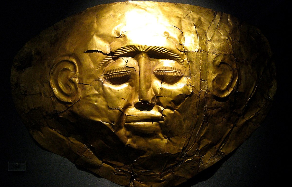
A gold Mycenaean death mask found in Greece. Credit: Sharon Mollerus / Wikimedia Commons / CC BY 2.0
Since the 19th century, several precious gold objects associated with the Mycenaean civilization have been discovered by archaeologists, predominantly at important burial sites where the royals and elite of Bronze Age Greece were buried.
The Mycenaeans were the first distinctly Greek culture to dominate mainland Greece during the late Bronze Age period between c. 1750 and 1050 BC. Their civilization was characterized by palatial states, advanced urban organization, and a written language dubbed Linear B by modern historians. It was during the Mycenaen age that the Trojan War purportedly happened, as retold in Homer’s Iliad.
The discovery of Mycenaean gold sheds light on the material culture of this enigmatic civilization but there are still many unanswered questions. For example, researchers are unsure whether the Mycenaeans crafted all of these items themselves, or whether they were obtained in trade and war.
The most famous examples of Mycenaean gold were discovered in two grave circles uncovered at the ancient Bronze Age site of Mycenae. Grave Circle A was discovered by Heinrich Schliemann in 1876 based on the descriptions of Homer and Pausanias. Grave Circle B was excavated in 1952 by archaeologists Ioannis Papadimitriou and Georgios Mylonas after workmen accidentally stumbled on the tombs a year before.
Both grave circles, dating back to the 16th century BC, contained impressive amounts of gold objects and other precious items. Unlike other Bronze Age tombs, they had not been discovered by the grave robbers and looted.
Grave Circle A contained 15 kg (33 lbs) of gold alone, making it one of the most substantial archaeological finds in all of Europe. Both grave circles contained hundreds of previous objects including jewelry, ornamental clothing attachments, decorated weapons, and highly distinctive funeral masks.
The Grave Circle An archaeological site at Mycenae. Credit: Andreas Trepte / CC BY-Sa 2.5 / Wikimedia Commons
The Death Mask of Agamemnon
The most iconic find is the so-called Death Mask of Agamemnon. Schleimann named the mask after the legendary Mycenaean King Agamemnon who led the Achaean Greeks in the Trojan War according to Homer’s Iliad. However, more recent research has indicated that the mask predates the time that Agamemnon was supposed to have lived by about three centuries.
The Mask of Agamemnon was crafted utilizing a single large gold sheet that underwent heating and hammering against a wooden surface. The intricate details were then added through the process of chasing, using a sharp tool to etch them onto the mask.
There were six other death masks discovered in Grave Circle A. Of the seven masks, six belonged to adult males and one to a child. None of the women discovered at the gravesite were buried with ornate masks.
The masks in Grave Circle A exhibit similar characteristics, featuring flat foil-like layers of gold depicting round, bald faces with round eyes and prominent ears. In contrast, Grave Circle B includes a death mask made of electrum, placed in a container next to a buried body instead of being placed on the deceased. The scarcity of death masks in Grave Circle B suggests that the interred individuals held lower wealth or status compared to the abundance of valuable material found in Grave Circle A, including the death masks.
Mycenaean death masks. The one on the right is the so-called “Mask of Agamemnon”. Credit: Zde / CC BY-SA 3.0 / Xuan Che / CC BY 2.0 / Wikimedia Commons
The Royal Tombs at Pylos
The burials at Mycenae might have provided the most famous examples of Mycenaean gold, but they are not the only Bronze Age tombs where exquisite items have been found.
In 2019, a team of archaeologists discovered Bronze Age royal tombs situated near the royal palace of Pylos, said to have once been the seat of power for Nestor, the eldest among the Greek rulers who fought in Trojan War.
The larger tomb, which was once 12m (36 feet) wide and 4.5 meters (15 feet) deep, had stone walls that once stood as tall as the ground’s height. The underground chambers were originally covered by domes, but over time, the roofs and upper walls collapsed. Consequently, the tombs became buried beneath numerous melon-sized stones and a tangled mass of grape vines. In their excavation efforts, archaeologists from the University of Cincinnati, including Jack Davis, Sharon Stocker, and their colleagues, had to painstakingly clear away vegetation and manually remove the stones.
Mycenaean bronze sword with a gold hilt and featuring a lion motif, from Grave Circle B, Mycenae. Credit: Gary Todd / CC0 / Wikimedia Commons
What they discovered, however, was extraordinary. Among the debris, the floors of the burial pits were adorned with shimmering flakes of gold leaf, which had once embellished the walls and floors of the chambers. The tombs, although lacking the remains of their occupants – suggesting a potential disturbance in the distant past – were nonetheless filled with opulent artifacts such as jewelry, gold, bronze, and gemstones.
A particularly interesting find was a gold pendant bearing the image of the Egyptian goddess Hathor who presided over motherhood and the protection of the dead. The Greeks during later periods drew parallels between Hathor and Aphrodite but it is not entirely clear what she meant to the Mycenaean Greeks during the Bronze Age. In any case, the artifact hints at trade links between the Mycenaeans and Egyptians at the time of the burials, which are believed to be about 3,500 years old.
A gold elliptical diadem. Credit: I, Sailko / CC BY-SA 3.0 / Wikimedia Commons
Gold Mining in Mycenaean Greece
As pointed out in an academic paper authored by M. Vavelidis and S. Andreou, “Numerous objects of gold displaying an impressive variety of types and manufacturing techniques are known from the Late Bronze Age (LBA) contexts of Mycenaean Greece, but very little is known about the origin and processing of gold during the second millennium BC.”
This raises several questions, namely: where did the Mycenaeans source their gold from? Interestingly, the wider Argolid region in which Mycenae was itself located and where the discoveries were made of numerous stunning golden items, is bereft of gold. If the Bronze Age Greeks did their own mining it was therefore elsewhere in Greece.
According to Vavelidis and Andreou, “Ancient literature and recent research indicate that northern Greece is probably the richest gold-bearing region in Greece, and yet very little evidence exists regarding the exploitation of its deposits and the production as well as use of gold in the area during prehistory.”
16th century BC Mycenaean earring. Credit: Louvre Museum / Public Domain / Wikimedia Commons
Nevertheless, by examining the chemical composition of prehistoric artifacts from two settlements alongside the composition of gold deposits in their nearby regions, it becomes evident that gold was locally sourced in some parts of Greece. This finding also raises the possibility that a portion of the Mycenaean gold may have originated from northern Greece.
Furthermore, the discovery of small stone crucibles, one of which bore visible traces of gold melting, at the archaeological site of Toumba in Thessaloniki, proves that local production of gold items took place very early in ancient Greek history.
Beyond mining, the Mycenaeans may also have obtained gold via trade and war. In some cases, Mycenaean traders may have bought gold for Greek craftsmen to shape into various objects, and in other cases, they would have imported finished items.
The Mycenaeans were well-respected as warriors across the Eastern Mediterranean and sometimes fought in the armies of neighboring civilizations like the Egyptians as mercenaries. The leaders of these Mycenaean mercenary bands may have received gold as payments or gifts in exchange for their martial services.
Early Greek alphabet painted on the body of an Attic black-figure cup. Today, there are missing letters in the Greek alphabet. Credit: flickr / Dan Diffendale CC BY-SA 2.0
The Greek alphabet has changed in many ways over the course of its existence. This is hardly surprising, given that the Greeks have been using it for nearly three millennia. One way in which it has changed is that some letters that used to exist in the Greek alphabet are now missing. Which letters were these, and what do we know about them?
The first letters of the Greek alphabet
To start, let us establish how the Greek alphabet acquired its letters in the first place. According to ancient Greek historians, the Greeks adopted the Phoenician alphabet after the arrival of a Phoenician prince named Cadmus. Archaeology confirms that this occurred at some point in the ninth century BCE.
The Phoenician alphabet was composed of only consonants. When the Greeks adopted it, they modified it to include vowels as well. This was a major step forward in the development of writing.
According to Plutarch, a Greek historian of the first century CE, there were originally sixteen Greek letters. However, Hyginus, an earlier writer, reports that there were originally eighteen.
In reality, it appears that neither version is correct. Physical evidence in the form of ancient inscriptions reveals that the earliest Greek inscriptions made use of all twenty-two letters in the Phoenician alphabet. However, four of these were for sounds which did not exist in Greek, so they were modified into vowels.
Perhaps this is where Hyginus’ idea of eighteen original letters comes from, being a distorted memory of the eighteen original consonants. In any case, the total number of letters in the Greek alphabet increased over time.
Why are there some missing letters?
Some of the letters used in ancient Greek inscriptions are simply not in the modern Greek alphabet. Why is this? Simply put, the reason is that the Greek language itself has evolved over time, and the alphabet exists to comply to the needs of the language rather than vice versa.
Additionally, different dialects of the Greek language existed within the Greek world at the same time. Therefore, the needs of each dialect would not necessarily be covered by the same letters.
In the late fifth century BCE, the alphabet used by the Ionian Greeks became the official, standardized alphabet of Athens. Over the following century, it then replaced the local alphabets of other Greek regions. By that time, the dialect of the Ionian Greeks was such that their alphabet did not make use of all the letters that had once been in use. Rather, their alphabet used just twenty-four letters. Hence, what were the letters that the Greek alphabet used to have but no longer does?
Digamma
One of the most famous lost letters of the Greek alphabet is Digamma. This had the following form:
Ϝ
It is superficially very similar to the modern F, but the sound was completely different. It was essentially the modern w sound. In fact, the original name for this letter was ‘wau’, taken directly from the Phoenician name for this letter.
San
Another lost letter is San. This had the following form:
Ϻ
Like Digamma, this looks almost identical to a more familiar letter. In this case, it looks just like the modern letter M. However, like with Digamma, the sound indicated by this ancient letter was completely different. Unlike the modern M, the ancient San, or Ϻ, was used to indicate an s sound. This fell out of use in favor of the alternative letter Sigma, written as Σ.
Koppa
Another letter that is no longer in use is Koppa, which had the following written form:
Ϙ
This is similar to the modern Q in the English alphabet, and that is no coincidence. Koppa was still part of the Greek alphabet when the Latins adopted it, which led to this letter eventually becoming the Q in English. The English alphabet originated from the Romans. The sound Koppa indicated was a k sound. It eventually fell out of favor in Greek, being replaced by the alternative letter Kappa, written as Κ.
Sampi
This next letter is called Sampi. It was written as:
Ͳ
This is very similar to the modern T, but it is unrelated. That modern letter comes from the ancient Greek Tau which, of course, had a t sound. In contrast, the ancient Greek Sampi had some kind of s or sh sound, although the exact vocalization is unknown. In any case, it fell out of favor when this sound was no longer used.
Et si le gouvernement qui rabote et les syndicats qui s'indignent défendaient, sans le savoir, exactement la même chose ? La réforme de l'assurance chômage votée le 2 juin dit moins sur le milliard économisé que sur un pays qui a oublié, en soixante-dix ans, à qui appartient le salaire différé.
Il existe un document que cinq cent trente-huit mille Français ont signé l'an dernier, généralement un mardi ou un jeudi, dans un bureau des ressources humaines où l'on avait disposé pour l'occasion deux chaises, une bouteille d'eau et un parapheur, et ce document, né en 2008 d'un accord entre partenaires sociaux qui passait alors pour une révolution de velours, s'appelle une rupture conventionnelle. 538 433 homologations en 2024, selon la Dares. Un divorce à l'amiable entre le salarié et l'employeur, inventé pour solder sans drame, sans prud'hommes, sans humiliation, ce que le droit du licenciement rendait interminable.
Chaque matin, 7 articles du Courrier dans ma boîte mail, et en plus c'est gratuit... J'en profite dès maintenant
Deviens ton propre souverain
Email sent! Check your inbox to complete your signup.
No spam. Unsubscribe anytime.
C'est ce document paisible que le Parlement vient de transformer en variable d'ajustement budgétaire.
Les deux camps ont joué leur partition sans surprise. Côté gouvernemental, on dénonce les pré-retraites déguisées, les départs de confort, l'optimisation d'un dispositif devenu, dit-on, une machine à financer des transitions choisies. Côté syndical et à gauche, on dénonce le rabot, la précarisation, le énième tour de vis sur le dos des demandeurs d'emploi. Les uns veulent la cage moins chère. Les autres la veulent plus douillette. Personne, dans aucun des deux hémicycles, n'a demandé qui détient la clé.
Faut dire que la question n'est jamais à l'ordre du jour. On négocie les paramètres ; la propriété, elle, ne se discute pas.
Le détour par Tocqueville
Il y a, dans le second volume de De la démocratie en Amérique, une page que tout lecteur du Courrier connaît, et qu'il faut pourtant relire chaque fois que l'État français retouche un droit social, parce qu'elle décrit moins un régime politique qu'un climat. Tocqueville y imagine le pouvoir sous lequel s'endorment les démocraties et qui préfigure l'avachissement contemporain :
« Au-dessus de ceux-là s'élève un pouvoir immense et tutélaire, qui se charge seul d'assurer leur jouissance et de veiller sur leur sort. Il est absolu, détaillé, régulier, prévoyant et doux. Il ressemblerait à la puissance paternelle si, comme elle, il avait pour objet de préparer les hommes à l'âge viril ; mais il ne cherche, au contraire, qu'à les fixer irrévocablement dans l'enfance. »
Appliquons mot à mot. L'assurance chômage à la française n'est pas une assurance : c'est une tutelle. On n'y adhère pas, on y est affilié. On ne choisit ni l'assureur, ni la prime, ni les garanties, ni la durée de couverture. On ne peut pas en sortir, pas la comparer, pas la résilier. Et lorsque le tuteur a besoin d'argent, il modifie les garanties par la loi, rétroactivement pour les espérances, unilatéralement pour les contrats. Je suppose qu'un assureur privé qui réécrirait ainsi ses polices en cours rencontrerait assez vite un procureur. L'État, lui, rencontre une majorité.
Le pouvoir tutélaire n'a pas changé de nature depuis 1840. Il a changé de guichet.
Ce qu'on voit, ce qu'on ne voit pas
Reste à examiner le milliard, avec la méthode de Bastiat : ce qu'on voit, et ce qu'on ne voit pas.
Ce qu'on voit : un régime endetté, un milliard d'économies, quinze mille retours à l'emploi promis. Vertu budgétaire, sérieux gestionnaire, courage réformateur.
Et qui paie, en bout de chaîne ? La cotisation dite patronale — 4,05 % de chaque salaire — n'est pas un cadeau de l'employeur : c'est du salaire différé, une part de la rémunération que le salarié ne touche pas aujourd'hui pour être couvert demain. Quant à la part salariale, elle a été supprimée en 2018 et fondue dans la CSG : le salarié paie toujours, mais il ne le voit plus. On a effacé la ligne du bulletin de paie. On n'a pas effacé le prélèvement.
Ce n'est pas nouveau ; à le bien regarder, c'est même très français. L'Unedic naît en 1958 d'une convention entre patronat et syndicats — une assurance paritaire, gérée par ceux qui la financent, à laquelle l'État ne touche pas. Puis l'histoire s'écrit comme une lente digestion.
2008 : la fusion ANPE-Assedic crée Pôle emploi, et l'opérateur passe sous la main publique.
2018 : la cotisation salariale disparaît dans la CSG, et l'assurance devient pour partie un impôt.
2019 : les partenaires sociaux ne s'accordant pas, l'État écrit lui-même les règles par décret — carence, dégressivité, salaire de référence.
2021 : la contracyclicité indexe les droits sur la conjoncture, décidée d'en haut.
2023-2026 : les ponctions.
2026 : un accord négocié sous lettre de cadrage budgétaire, transposé par un Parlement qui rabote.
Chaque décennie apporte sa réforme paramétrique — durée, taux, différé, plancher — et chaque réforme laisse intacte la seule question qui vaille : la cotisation appartient-elle à celui qui la verse ? On réforme l'usufruit. On ne rend jamais la nue-propriété.
Et les assurés acceptent chaque tour de vis avec cette résignation de troupeau qu'on tond à date fixe, et qui s'étonne moins du froid que du changement de calendrier.
Pendant ce temps
Pendant que les deux hémicycles se disputaient trois mois d'indemnisation, la Cour des comptes publiait cette semaine son examen des conséquences budgétaires de la démographie française — la bombe lente que personne ne désamorce — et l'Agence France Trésor poursuivait son programme d'émissions : plus de 530 milliards d'euros à lever cette année, un record absolu, avec un écart de taux franco-allemand installé à 69 points de base. La question de savoir qui paiera la tutelle quand la pyramide des âges aura fini son œuvre n'a été posée nulle part. Elle aurait pourtant rendu le débat sur les quinze mois presque reposant.
Dernier mot
Que ferait une société libre ? Quelque chose de très simple et de très improbable : elle rendrait la cotisation au salarié. Un compte individuel, portable d'un emploi à l'autre, alimenté par ces 4,05 % qui sont son salaire différé ; le droit d'en confier la gestion à l'assureur de son choix — mutuelle, caisse syndicale, compagnie, et pourquoi pas l'Unedic, qui concourrait comme les autres ; la liberté d'arbitrer soi-même entre durée de couverture et niveau de garantie. La solidarité véritable — chômage de longue durée, accidents de la vie — relèverait de l'impôt : voté, visible, assumé, au lieu d'être dissimulé dans la tuyauterie d'un régime que l'État pille d'une main et rabote de l'autre. Le système de Gand, où des caisses volontaires assurent les salariés, fait vivre cette idée au Danemark et en Suède depuis un siècle — pays dont je ne sache pas qu'ils passent pour des jungles libérales.
Peut-être cette réforme produira-t-elle son milliard ; peut-être même ses quinze mille emplois. Là n'est pas l'objection. L'objection, c'est qu'on aura une fois de plus ajusté la pension de l'assuré sans jamais lui demander son avis sur l'assurance — et qu'on appellera cela, sérieusement, fébrilement, presque pieusement, un progrès du dialogue social.
Le jour où un salarié lira, au bas de son bulletin de paie, le nom d'un assureur qu'il aura choisi, la réforme aura eu lieu. En attendant, on rabote la rente. La cage, elle, vient d'être repeinte.
An ancient Greek grill for souvlaki from Akrotiri, Santorini. Credit: Wikimedia Commons/ Public domain
The beloved souvlaki has been around since ancient times. Archaeologists have found skewers dating back to the Bronze Age, and recent research looks at the functioning of early grills. In particular, “souvlaki trays” have been discovered dating all the way back to Mycenaean culture.
Therans and Mycenaean cultures were known for their luxurious lifestyles, ornate and colorful clothes, exquisite art, and sea trade with other cultures, such as Egypt. People developed these cultures on the islands of Crete and Santorini.
World’s oldest Bronze Age souvlaki on Santorini
The oldest souvlaki skewers found seem to be those discovered by archaeologists on Santorini dating back as far as 2000 BC. There are traces of the popularity of souvlaki on Santorini and Crete through the Bronze Age, and both Theran and Mycenean cultures made use of this method of cooking.
Ancient bronze skewers and a vase. Credit: diffendale/CC BY-NC-SA 2.0.
Ancient Greek texts such as the Iliad and the Odyssey describe a spit (Greek: ὀβελός) being used to roast meat, but the exact functioning of the souvlaki trays was unknown until recently. The works of great poets and writers describe the same obeliskos being popular. Sophocles, Aristophanes, Xenophon, and Aristoteles all mention or describe the popular dish in their works.
Mycenean cooking and culture
It seems that ancient Mycenaeans did not have a large variety of foods available to them. Despite this, they developed various types of cooking methods, fostering innovation. Part of that innovation was souvlaki trays, as was cooking in jars, among other techniques. At the time and for most of ancient history, cooking was mostly done on hearths with few ingredients. The portable and lightweight souvlaki trays changed this for Mycenaeans around 1400 to 1050 B.C.
Academics suggest that an important historical force behind these contraptions was status. While the Myceneans had incredibly rich art and fashion, their diet lacked diversity, though a marker of status was drinking wine. On the other hand, one can imagine poorer Mycenaeans drank beer.
As they were skilled sailors, Therans on Santorini island had begun brewing beer in the II millennium B.C., possibly learning the skill from Egypt or the Near East, where beer had been brewed since the III and IV millennium B.C. Accounts of the 5th and 4th centuries B.C. tell of an Athenian bias against beer. It was considered a drink of barbarians, Egyptians, or even women. Beer brewing was never seen as valuable.
By the Classical period, this all changed. Wine had become readily available to all, pushing elites in later Greek societies to seek other ways to distinguish themselves — for instance, through the use of specific gadgets and kitchen appliances, echoing earlier innovations like the Mycenaean souvlaki trays.
The souvlaki tray
The souvlaki trays found in Gla, Pylos, and Crete added something to the age-old tradition. Similar to modern-day outdoor grills, they were designed to be portable and good for travel or entertainment. Meat cuts seem to have been similar to the ones popular for souvlaki today, made from either lamb, pork, or mutton, and the meal was accompanied by bread made of various cereals.
The clay trays had placeholders for the skewers and, until recently, how they actually functioned was unknown. Researchers at Dartmouth College have recreated the trays using original ancient pottery techniques, tools, and ingredients. They realized the trays were not meant to be put on a hearth as originally thought. Rather, embers were placed in the tray and the skewers were grilled. They were practical, portable, and delicious!
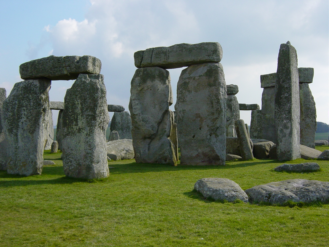
Stonehenge Altar Stone. Credit: Wikimedia Commons / Public Domain
The massive Altar Stone at Stonehenge may have received some help from ancient glaciers on its long journey to southern England, but people still likely carried it much of the remaining distance, according to new research.
The study, led by Anthony J. I. Clarke and published in the Journal of Quaternary Science, examined the possible origins and transport routes of the six-ton sandstone monument that sits at the center of Stonehenge.
Researchers have long believed the Altar Stone came from northeast Scotland, roughly 700 kilometers (435 miles) from Stonehenge. However, exactly where the stone originated and how it reached Salisbury Plain have remained major archaeological mysteries.
Searching for the stone’s birthplace
The team combined geological analysis with computer models of ancient ice sheet movements to investigate whether glaciers could have transported the stone southward during the last Ice Age. Scientists focused on the Orcadian Basin, a large geological region in northeast Scotland that has been proposed as the stone’s source.
How did a 6-ton stone reach Stonehenge from Scotland?
Researchers found that glaciers may have moved the monument's famous Altar Stone part of the way. But ancient people likely completed the final journey, hauling the massive rock hundreds of kilometers across Britain. pic.twitter.com/mQFbTIb3ve
— Tom Marvolo Riddle (@tom_riddle2025) June 4, 2026
The study compared the Altar Stone’s mineral signature with sandstone formations across the basin. Researchers looked specifically at the ages of zircon grains embedded in the rock. These grains act like geological fingerprints and can help identify where a stone was formed.
The results pointed most strongly toward Caithness in mainland northeast Scotland. Sandstones from that region showed the closest match to the Altar Stone’s zircon age patterns.
Ice movement presents a problem
Although Caithness appears to be the best geological match, computer models revealed a complication.
Ancient glaciers in the area mostly moved toward the northeast rather than toward southern England. The models showed only a limited pathway that could have carried material southeast toward Dogger Bank, a now-submerged area beneath the North Sea.
That finding makes a direct glacial journey to Stonehenge unlikely. Researchers concluded that glaciers alone could not explain how the stone reached its final location.
Human transport still likely
Even if glaciers carried the stone as far as Dogger Bank, people would still have needed to move it about 400 kilometers (250 miles) to Stonehenge.
The study also noted another challenge. Dogger Bank was flooded by rising sea levels after the Ice Age before the Altar Stone is thought to have arrived at Stonehenge. This creates a timing problem for any theory relying entirely on glacial transport. As a result, researchers suggest that ice may have played only an intermediate role in the stone’s journey.
The findings support the idea that Neolithic communities were responsible for moving the enormous stone over great distances. While glaciers may have shortened part of the route, substantial human effort would still have been required to bring the Altar Stone to Stonehenge, one of the world’s most famous prehistoric monuments.
The study adds a new piece to the puzzle of how ancient builders assembled Stonehenge and highlights the remarkable achievements of the people who constructed it thousands of years ago.
New archaeological evidence suggests that Paleolithic humans may have baked simple types of bread as early as 30,000 years ago. Credit: 2368zauber, Wikimedia Commons, CC-BY-SA-3.0
For decades, conventional wisdom held that bread didn’t exist among Paleolithic people and was a relatively recent human innovation, an agricultural byproduct that emerged with the rise of farming in the Neolithic era, roughly 10,000 years ago. Recent archaeological discoveries have radically challenged this view, however, pushing the timeline of breadmaking back by at least 20,000 years.
In what can only be described as a groundbreaking study, a team of Italian researchers has revealed that Paleolithic hunter-gatherers in Europe not only consumed wild plants but also processed them into flour and baked a primitive flatbread. These findings were published in the prestigious journal Proceedings of the National Academy of Sciences (PNAS). They suggest that the roots of culinary innovation run far deeper than previously imagined.
Grinding stones and starch residue
At the heart of this discovery are ancient grinding stones. The archaeologists unearthed these flat stone slabs and pestle-like tools at sites across Italy, Russia, and the Czech Republic. The tools, dated to around 30,000 years ago, were originally assumed to have been used for processing pigments or crushing seeds. Nevertheless, when researchers Anna Revedin and Laura Longo of the Italian Institute of Prehistory and Early History in Florence conducted a detailed microscopic analysis, they uncovered traces of starch granules embedded in the stone surfaces.
The starches were identified as those of cattails, ferns, and other starchy wild plants, which would have required careful preparation to be rendered digestible. Revedin’s team concluded that these Paleolithic humans had not only harvested the plants but had dried, ground, and mixed them with water to form a kind of dough. Additionally, they likely cooked the resulting paste on hot stones near the fire, producing an early version of unleavened bread.
Rethinking the Paleolithic diet
The ancient Greeks themselves had a clear grasp of the evolution of human diet. Hippocrates, the father of medicine, wrote in his work On Ancient Medicine:
“It is for this reason, I believe, that people sought out food more suited to human nature, and eventually discovered the kind we now use. From wheat, after soaking, grinding, kneading, sifting, and baking, they made bread; from barley, they made flatcakes. After many efforts, they cooked, baked, mixed, and blended foods, diluting the strong and raw with milder ingredients, shaping everything according to human nature and capacity.”
The implications are profound. Until now, the standard narrative of Paleolithic diets emphasized a reliance on animal protein. This included meat and fish, with foraged fruits and plants playing only a minor role. The recent discovery challenges that model, however. Moreover, the implication is that these early humans were actually greatly skilled in the complex processing of wild plant foods. In other words, they also possessed the sophisticated ability to cook.
Furthermore, the evidence of flour production long before the advent of agriculture hints at a continuity of knowledge. The leap from gathering and grinding wild plants to cultivating domesticated grains may not have been as abrupt or revolutionary as once believed. Paleolithic peoples were far from passive consumers of raw resources, and the rise of farming could in fact have been the result of millennia of experimentation, habit, and accumulated expertise.
Ancient Greek woman taking bread out of the oven. Terracotta figure found in Tanagra, Greece. Credit: Marie-Lan Nguyen CC BY 2.5
A quiet revolution
Perhaps most striking is what this discovery on bread reveals about Paleolithic ingenuity. The production of flour and bread is not simply a dietary choice. It reflects planning, patience, and an understanding of food chemistry. Drying plant roots, grinding them into powder, and then baking them requires more than survival instinct. It also requires culture.
As more research sheds light on the lives of our Paleolithic ancestors, it becomes increasingly clear that they were not the brutish cave-dwellers of outdated caricatures. They were observant, resourceful, and remarkably sophisticated in their interaction with the natural world.
Bread, it turns out, is not just the food of civilization. It may have been the food of pre-civilization, as well.
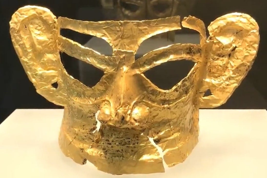
Sanxingdui gold mask. Credit: 中国新闻网 / Wikimedia Commons / CC BY 3.0
Ancient carnelian beads unearthed at the Sanxingdui Ruins in southwest China are providing new evidence of long-distance trade and cultural connections that linked distant regions during the Bronze Age, researchers said Tuesday.
The discovery was announced by the Sichuan Provincial Cultural Relics and Archaeology Research Institute, which recently studied 11 carnelian beads recovered from sacrificial pits at the famous archaeological site in Sichuan Province. The artifacts date to about 1200 to 1000 B.C.
According to Liu Jiancheng, an associate researcher at the institute, the beads are the southernmost known carnelian artifacts from the same period found in China. Their discovery is helping researchers trace the movement of valuable materials and ornamental goods across ancient East Asia.
Analysis traces beads to northern China
Carnelian is a reddish-orange gemstone that was widely used in ancient jewelry and decorative objects. Researchers conducted trace element analysis on the Sanxingdui beads and found that the raw materials did not originate in the Sichuan Basin.
Instead, the analysis traced the source of the stone to the Yanshan orogenic belt and regions farther north, more than 1,000 kilometers (620 miles) from Sanxingdui. The findings indicate that the materials traveled great distances before reaching the ancient Shu civilization.
Researchers also compared the beads with carnelian artifacts discovered at archaeological sites in Gansu, Shaanxi, and Beijing from roughly the same period. The chemical signatures closely matched those of the northern examples, suggesting they likely originated from related sources.
Evidence points to an extensive exchange network
The results point to the existence of a broad exchange network operating between 1500 and 1000 B.C. Researchers believe the network connected communities across the southern Mongolian Plateau, the Loess Plateau, the eastern Qinghai-Tibet Plateau, the Central Plains, and the Sichuan Basin.
The findings offer new insight into how goods moved across ancient China long before the establishment of formal trade routes. They also suggest that materials, technologies, and cultural influences circulated between regions that were separated by vast distances.
Discovery adds to Sanxingdui’s significance
Sanxingdui, located near the city of Guanghan, is one of China’s most important archaeological sites. The site has gained international attention for its extraordinary bronze masks, statues, and ritual objects, which have reshaped the understanding of early Chinese civilization.
Liu said the latest discovery shows that the Sanxingdui society participated in a far-reaching network of exchanges about 3,000 years ago. That network extended into northern China and may have reached as far as the Mongolian Plateau.
The researcher said the evidence highlights the depth of interaction among different cultures during China’s Bronze Age. The discovery also supports the view that a broader and increasingly interconnected Chinese civilization was already taking shape thousands of years ago, while regional societies continued to maintain their own distinct identities.
À la frontière entre l'Inde et le Bangladesh, deux géants se jettent dans l'océan : le Gange et le Brahmapoutre. Alors que leurs bras se divisent, ces fleuves forment le plus grand delta du monde, qui s'étend sur plusieurs milliers de kilomètres carrés. Longtemps en conflit, grands félins et habitants tentent de résister à l'afflux des touristes, aux cyclones et à la montée des eaux.
Toutes les photographies de cette double page sont de Bertrand Daugeron. Dans la gare de Calcutta, une fresque représente le parc national des Sundarbans, 2026
Les Sundarbans indiens, là où les bras des deltas du Gange et du Brahmapoutre s'enlacent. Près de 10 000 kilomètres carrés de terres et d'eaux partagées entre l'Inde et le Bangladesh, à l'embouchure du système fluvial Gange-Brahmapoutre, sur le golfe du Bengale. Côté indien : 4 200 kilomètres carrés, 102 îles, dont 54 sont habitées. Une forêt de mangrove classée au patrimoine mondial de l'Organisation des Nations unies pour l'éducation, la science et la culture (Unesco) depuis 1987 — la plus grande et la dernière encore intacte du monde. Et une donnée physique qui commande tout : 70 % des terres se situent entre 1,50 et 3 mètres d'altitude. Aucun relief, pas d'élévation refuge. Le delta tout entier affleure au niveau de la mer. Dans certaines sections, les digues sont déjà en dessous.
La zone de transition de la réserve regroupe cinq millions de personnes. Jusqu'en 1973, les communautés pouvaient venir puiser dans les ressources de la forêt : pêche dans les chenaux intérieurs, récolte de miel. Cette année-là, le gouvernement indien crée la Sundarban Tiger Reserve, premier pas vers une séparation stricte qui va se construire par étapes. En 1984, le cœur de la forêt devient parc national : accès totalement interdit. En 1989, l'ensemble du delta (forêt protégée et îles habitées) est désigné réserve de biosphère.
« Pourquoi le tigre attaque-t-il ? »
Certains blocs forestiers de la zone tampon, qui borde le parc, restent accessibles aux pêcheurs locaux, sous permis saisonnier, pour un nombre d'espèces limité. Mais à Sajnekhali, non loin du village de Pakhiralay, sur l'île de Gosaba, le contrôle est strict et s'impose à tous — pêcheurs, habitants, touristes. Une ligne est tracée entre deux mondes. D'un côté, le naturel administré. De l'autre, l'humain contraint. Entre les deux, une économie qui s'est réorganisée, partiellement, autour de cette séparation, avec le tourisme et l'espoir d'un développement économique.
L'agent du Sajnekhali Wildlife Sanctuary (sanctuaire faunique de Sajnekhali) en compagnie duquel nous patrouillons depuis trois heures s'arrête soudain, en regardant alentour : impossible ici de planifier au-delà de dix ans, explique-t-il. Dans l'intervalle, tout aura disparu.
Chaque jour, qu'il pleuve ou qu'il vente, pendant qu'une myriade de bateaux de touristes naviguent à l'affût d'un grand félin, une équipe de rangers inspecte les filets : plus de cent kilomètres de nylon tendu entre les chaumes de bambou courant en lisière de mangrove sur tout le périmètre. Il s'agit de protèger l'île de Gosaba du tigre du Bengale, et la nature des intrusions humaines : la pêche, la chasse et, désormais, les appareils photo. Cette protection, réalisée par les villageois — à la demande du sanctuaire de Sajnekhali par l'intermédiaire de comités locaux de villages (Joint Forest Management Committe, JFM) —, établit une séparation physique entre le monde des hommes et celui de la nature.
Chassé-croisé de touristes à l'embarcadère, 2026
Bertrand Daugeron
Côté habité, les digues, levées de terre protégées par des toiles qui longent les berges, séparent les villages de l'eau, tentent de retenir ce que le delta voudrait reprendre. Côté nature, la mangrove, barrière physique et symbolique. Entre les deux, les chenaux. La Datta River. L'eau qui circule, qui érode, qui élargit.
Quelque part derrière les clôtures, des caméras pièges enregistrent en continu. Dans un bureau, chaque félin est identifié par ses rayures, telles des empreintes digitales. L'œil mécanique identifie ce que l'œil humain ne voit pas. On sait, depuis le recensement de 2022, qu'il y a ici cent un tigres et qu'ils ne traversent plus le bras de mer. On ne les voit pas ; eux nous voient. Avant les filets, les chasseurs de miel qui s'enfonçaient dans la mangrove portaient un masque avec des yeux peints derrière la tête. Le tigre attaque par-derrière : ne jamais lui tourner le dos. Aujourd'hui, le masque a été remplacé par les protections en nylon.
Si, depuis quelques années, les incidents ont quasi disparu, leurs rares occurrences incitent à la réflexion. « Pourquoi le tigre attaque-t-il ? », interroge l'agent. Parce qu'on entre dans son territoire. « Il ne chasse pas, il se défend. » Cette lecture change tout : il ne s'agit plus de neutraliser l'animal, mais de le tenir à distance. D'où les filets.
Il faut encore aider les félins à résister à la transformation de leur territoire. Or les chiffres suggèrent que cela n'a rien d'aisé. La réserve comptait 274 tigres en 2004. Il en reste moins de la moitié. Ce déclin observé dans les 56 réserves de tigres en Inde a conduit à sanctuariser ce territoire en 2007. Comme une dernière ligne de défense pour une population gravement menacée par la réduction de son espace vital, par la chasse et par le braconnage, qui réduisent ses ressources. On gagne la bataille du contact homme-animal, pas celle de l'habitat.
Inspection quotidienne des filets longeant les rives, la frontière avec le monde naturel, 2026
Bertrand Daugeron
L'agent de protection des forêts du sanctuaire se trouve au cœur de cette organisation spatiale. Quand on lui demande si la situation est difficile pour les populations locales, il répond sans hésiter : « La vie est dure pour tous. » Il marque une pause, et complète : « Pour les hommes, pour les animaux, et pour le territoire. » Un simple état des lieux.
Le fleuve est large, ses eaux sont « internationales ». Aujourd'hui, sept cents mètres séparent l'île de Gosaba de la rive d'en face. Il y a vingt ans, elles étaient à portée de voix l'une de l'autre. Un homme peut avoir vu ça dans sa vie : le fleuve qui s'installe, mètre après mètre, dans ce qui était de la terre. L'eau qui gagne, la berge qui cède, et personne pour l'arrêter. Ici, la géographie fluctue. C'est une donnée qu'on subit, qu'on intègre.
La mangrove ne rend pas ses morts
Sur la digue qui longe Gosaba, les berges récemment reconstruites côtoient des bâtiments en ruine éventrés par l'érosion : murs penchés sur l'eau, toitures échouées dans la vase — dont celles des bureaux des rangers, qui ont dû être reconstruits cent mètres plus loin. La digue elle-même ressemble à un rempart médiéval ; elle sépare deux mondes que tout condamne à se rejoindre. D'ailleurs, elle vient d'être rehaussée, par précaution. D'un côté, la mangrove splendide, intacte, inaccessible. De l'autre, le village, les petits hôtels qui se construisent, les groupes de touristes qui débarquent avec leurs valises à roulettes et repartent avec des tigres en peluche.
Pour l'agent de protection des forêts, cet espace se trouve confronté aux besoins spécifiques de trois acteurs : les villages, le parc et l'industrie du tourisme. Trois forces qui coexistent, qui dépendent les unes des autres, et qui se contredisent en permanence, dans un équilibre précaire que chaque perturbation menace, et que chaque réponse ne fait que déplacer.
Ici, la « perturbation » porte un nom : cyclone. Du 23 au 28 mai 2021, celui baptisé Yaas a balayé le site cinq jours durant. Les digues ont rompu en deux cents points. Les images sont encore dans toutes les têtes. Elles ont fait le tour du monde. Les routes, l'éclairage public, les protections contre l'eau : tout est à reconstruire à la main ; tout doit être transporté par bateaux. Coût estimé par le gouvernement du Bengale-Occidental ? L'équivalent de 2,3 milliards d'euros. Entre 2019 et 2022, quatre cyclones destructeurs se sont succédé : Fani, Bulbul, Amphan, et puis Yaas. Le district de South 24 Parganas, au sud de Calcutta, enregistre un cyclone majeur tous les trois ou quatre ans. Soit le temps qu'il faut pour réparer les dégâts du précédent.
Mais les destructions ne tiennent pas seulement à la survenue des cyclones. Si Aila, un phénomène de puissance modérée apparu en 2009, a submergé l'intégralité du territoire, c'est qu'il a coïncidé avec une marée de vive-eau. Yaas a frappé exactement au moment du pic. Or les terres inondées par l'eau salée restent impropres à toute culture pendant deux ou trois ans, au moins.
Avec les gardes forestiers, lors de la surveillance des rives du sanctuaire du tigre, 2026
Bertrand Daugeron
Les pêcheurs sont les premiers à subir le choc. La quantité de poisson n'est déjà plus suffisante. Crabes, crevettes et poissons sont vendus au marché local, sans que cela donne aux plus modestes des pêcheurs la capacité d'investir ni de faire face au moindre aléa. Après chaque cyclone, la migration s'accélère. Des familles entières doivent désormais compter sur les revenus d'un membre parti travailler dans un autre État du pays. Suraj a une vingtaine d'années. Il conduit un touk-touk électrique entre le village et l'embarcadère — touristes le matin dès 5 heures, groupes en milieu de matinée. La saison dure quelques mois. Le reste de l'année, il part à Bangalore, où il nettoie des appartements de standing. Il ne se plaint pas, il calcule. Et puis, il y a ces hommes qui peuvent rester, encore un temps, comme manœuvres et maçons. Débarquer les matériaux : sable, ciment, briques, gravier. Construire les hôtels. Se reconvertir. De pêcheur, devenir bâtisseur, avant que le prochain cyclone n'avale tout. Le chef des rangers ajoute : « Vous saisissez la pression psychologique ? Vivre entre deux catastrophes. »
Cyclones, marées… À ces deux forces destructrices s'ajoute une troisième, plus silencieuse. Chaque année, les rivières changent de cours, phénomène naturel dans un delta alluvial. Mais il est ici accéléré par le trafic maritime international. Les digues ont, au fil des ans, bloqué les flux tidaux qui apportaient les sédiments permettant aux îles de se recharger. Le lit des rivières s'élève, les îles s'affaissent, la mer monte. Depuis 1973, le delta indien a perdu 478 kilomètres carrés de terres par érosion, tandis que seuls 400 ont été gagnés par l'accrétion sédimentaire due aux apports fluviaux. Les eaux salées du golfe du Bengale entrent dans le delta, les eaux douces reculent. Par capillarité, le sel remonte dans les terres.
Ici, la géographie varie, nous explique l'agent. Ce qui rend caducs tout plan à long terme, toute infrastructure pensée pour durer, tout équilibre cherché entre les trois pôles avant que le prochain cyclone ne remette les compteurs à zéro.
Une réserve humide administrée par le département forestier, 2026
Bertrand Daugeron
Chaque matin, à l'aube, les premiers bateaux quittent les embarcadères pour ramener les touristes de la veille vers le continent. En milieu de matinée, les groupes suivants arrivent avec leurs guides locaux et tour-opérateurs qui vendent des formules tout compris : hôtel, réserve, restaurant. La région accueille de 200 000 à 300 000 visiteurs par an selon l'Institut indien pour la faune sauvage (WII), concentrés sur moins de 35 % du territoire. Une pression croissante sur un espace fermé et fragile.
Le département des forêts délivre les immatriculations des cinq cents bateaux en activité ainsi que les permis pour les touristes (leur nombre étant régulé). Il redistribue 40 % des revenus aux communautés via les comités de cogestion de la forêt de chaque village. Les 60 % restants sont pour le fonctionnement et le développement du territoire. Le tourisme n'est pas une menace venue de l'extérieur, mais la reconversion forcée d'une population dont les bases économiques traditionnelles ont disparu. Quand la mer prend les terres et que la forêt se ferme aux exploitations traditionnelles, le tourisme devient la seule ressource locale viable. Encore faut-il parvenir à un équilibre, fragile. Celui que recherche l'agent : ni trop ni trop peu. Plus de tourisme, c'est plus de revenus pour les communautés et plus de pression sur un écosystème fragile. Moins de tourisme, c'est moins de dégradation, mais moins d'argent pour une région qui n'a plus d'autre option.
La digue récemment refaite, un rempart contre les éléments naturels, 2026
Bertrand Daugeron
Prodip a la cinquantaine. Il tient l'accueil de l'un des plus récents hôtels de la région. En 1981, son père est parti dans la forêt et n'est pas rentré. Son corps n'a jamais été retrouvé. La mangrove ne rend pas ses morts. Aîné d'une famille de trois garçons et une fille, Prodip avait alors une dizaine d'années. Pendant dix jours, il n'y a rien eu à manger. Alors il a travaillé, pour que ses frères et sa sœur puissent aller à l'école.
Quarante ans plus tard, son fils Arjun, 19 ans, fait la cuisine dans le restaurant de l'hôtel. À côté, des murs à mi-hauteur, les fondations d'un restaurant que Prodip construit depuis quelque temps, au gré des fonds qu'il parvient à rassembler. « Il faut bien ! » Les gens viennent voir le tigre, celui qui a pris son père. Par un curieux renversement, l'animal qui a détruit sa famille hier est devenu la condition de sa survie.
Alors, jusqu'à quand, cet équilibre précaire ? « On n'en sait rien », répond l'agent. Objectifs à court terme uniquement. Planifier à long terme dans les Sundarbans, c'est construire sur ce qui bouge. Alors on fait autrement. On construit ce qui peut tenir jusqu'au prochain cyclone. On réparera ce que le suivant aura défait. Et puis, on recommencera.
Nicolas Cage always wanted to be a superhero. Not surprisingly, his stage name (his real surname is Coppola, since he is the nephew of the director) comes from Marvel’s strongman Luke Cage. As if that weren’t comic-bookish enough, his son is named Kal-El (like Superman). His collection of 400 classic comics included the first Action Comics, which he bought for $150,000, someone stole at a party and which later got sold for $15 million. Hollywood’s most singular superstar still couldn’t be Tim Burton’s Superman, and although he settled for the skull-faced Ghost Rider, at age 62 Cage finally gets the chance to play another great: the new television Spider-Man. There is, however, a twist in his Spider-Noir: this wall-crawler is also a detective in 1930s New York.