Normal view

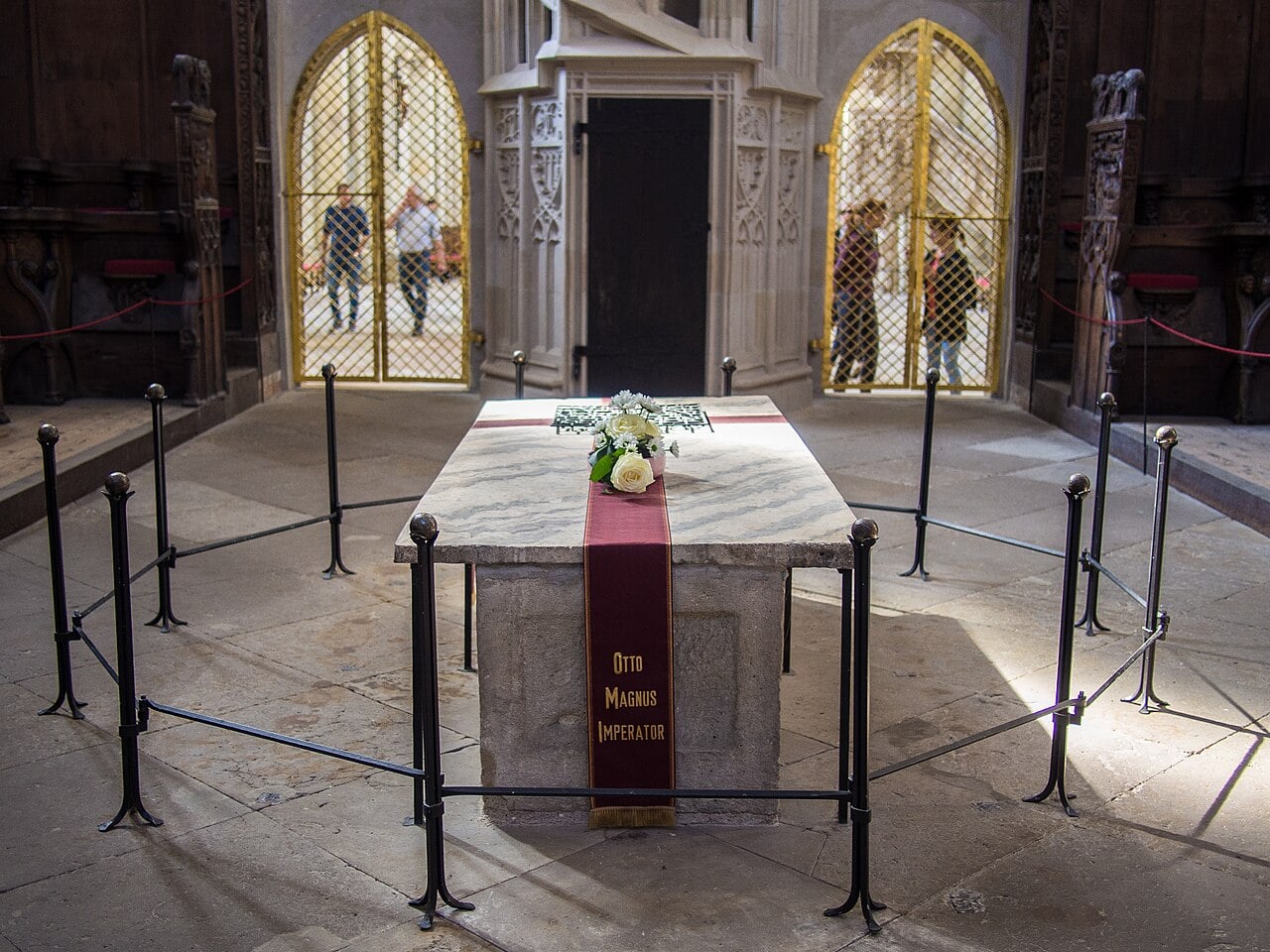
Emperor Otto the Great’s Tomb Yields New Clues During Cathedral Restoration

12 June 2026 at 21:31
Tomb of Otto I in Magdeburg Cathedral
Tomb of Otto I in Magdeburg Cathedral. Credit: Mar Yung / Wikimedia Commons / CC BY 2.0

Conservation experts and archaeologists are uncovering new details about the tomb of Emperor Otto I while carrying out an extensive restoration project at Magdeburg Cathedral.

Since January 2025, the Saxony-Anhalt Cultural Foundation and the State Office for Heritage Management and Archaeology have led efforts to preserve the heavily damaged burial site of Otto the Great, the 10th-century ruler who laid the foundations of the Holy Roman Empire.

Excavations uncover clues to the tomb’s history

The relocation of the sarcophagus also allowed archaeologists to investigate its foundation for the first time. Excavations revealed large sandstone blocks beneath the tomb, including reused building stones marked by late medieval stonemasons. The findings suggest that the sarcophagus was moved several times over the centuries.

Excavations produced numerous artifacts, including coins, glass beads, ceramics, roof tiles, clothing pins, and fragments of painted plaster from earlier cathedral structures. Researchers also uncovered a lead bullet beneath the floor, reflecting Magdeburg’s turbulent history.

Archaeologists restoring the tomb of Emperor Otto I in Magdeburg Cathedral have uncovered medieval foundations, underground passages and centuries-old artifacts. pic.twitter.com/B1PNeRTlwq

— Tom Marvolo Riddle (@tom_riddle2025) June 12, 2026

Researchers also uncovered layers of rubble linked to medieval and early modern construction activities in the cathedral’s High Choir. A network of underground passages, some possibly dating to the Middle Ages, was also documented.

Despite the discoveries, archaeologists found no evidence showing whether Otto I’s tomb occupied the same location in an earlier cathedral that once stood on the site. The original placement of the emperor’s burial, therefore, remains uncertain.

Damage prompted conservation efforts

Otto I, who was crowned emperor in 962, established one of medieval Europe’s most powerful empires. His tomb in Magdeburg Cathedral is considered one of Germany’s most important medieval monuments.

The project began after routine inspections in 2024 revealed serious deterioration in the emperor’s tomb. Researchers identified several threats to the monument, including corroded iron fittings, rising moisture from the ground, and fluctuating humidity levels inside the cathedral.

Scientific analyses confirm the emperor’s remains

As part of the conservation work, experts carried out extensive non-invasive documentation of the sarcophagus and its surroundings. The marble cover slab, weighing about 300 kilograms (660 pounds), was removed so researchers could examine the damaged wooden coffin inside.

Anthropological and genetic analyses later confirmed that the human remains belonged to Otto I, supporting centuries-old historical accounts of his burial at the cathedral.

The emperor’s remains are scheduled to be reinterred on Sept. 1, 2026, in a newly designed coffin currently being created through a competition organized by the Saxony-Anhalt Art Foundation.

Restoration work addresses long-term damage

To protect the monument for the future, conservation teams moved the limestone sarcophagus from its original location in early 2026 using a specially designed transport structure. The sarcophagus now sits inside a secure enclosure within the cathedral, where restoration work is underway.

Specialists are removing corroded iron nails and clamps, many believed to date to the 19th century. As the metal rusted over time, it expanded and placed pressure on the stone, increasing the risk of cracking. Conservators are also removing harmful iron residues from the marble cover slab.

Cathedral remains open during conservation work

Church services continue as normal during the project, while visitors can still view major features of the cathedral, including the High Choir and its famous 13th-century sculptures. Officials said the public will continue to receive updates as restoration and research progress.

Ancient Whale Necropolis Found 23,000 Feet Beneath the Indian Ocean

12 June 2026 at 19:01
A 5.3-million-year-old deep-sea whale necropolis
A 5.3-million-year-old deep-sea whale necropolis. Credit: Xiaotong Peng / CC BY-NC-ND 4.0

Scientists have discovered a massive whale necropolis deep beneath the Indian Ocean, at depths reaching nearly 7,000 meters (22,966 feet), stretching almost 1,200 kilometers (746 miles) along the seafloor and containing hundreds of fossils dating back more than five million years.

The findings, published in Nature, offer a rare look at one of the ocean’s most extreme and least understood environments.

The site sits in the Diamantina Zone, a rugged underwater fracture zone in the southeastern Indian Ocean, at depths between 4,616 and 7,001 meters (15,144 and 22,969 feet).

Lead author Xiaotong Peng of the Institute of Deep-sea Science and Engineering at the Chinese Academy of Sciences in Sanya, China, and a team of researchers made 32 deep-sea dives using the submersible “Fendouzhe” from February to March 2023.

Whale necropolis beneath the Indian Ocean pushes known depth limits

Researchers found 476 fossilized whale remains and five active whale-fall communities, the ecosystems that form around carcasses sinking to the ocean floor.

The deepest of these communities was found at 6,789 meters (22,274 feet), extending the known depth range of whale-fall habitats by more than 2,500 meters (8,202 feet).

In some areas of the zone, whale remains reached densities of up to 759 individuals per square kilometer (1,966 per square mile).

Images of whale falls in reef stage
Images of whale falls in reef stage. Credit: Xiaotong Peng / CC BY-NC-ND 4.0

All five active whale-fall communities are in what scientists call the “sulfophilic stage,” a prolonged phase where bacteria break down bone fats and release sulfide compounds that sustain surrounding life.

The team identified 35 animal species at these sites, including bone-eating worms, brittle stars, and chemosynthetic bivalves, creatures that draw energy from chemicals rather than sunlight. Molecular analysis showed that most of these species may be entirely new to science.

Researchers examined 43 fossil specimens and identified five ‘beaked whale’ species and one ‘baleen whale’ species. Two of the ‘beaked whale’ species still inhabit those waters today, while others have been extinct for millions of years.

One fossil belongs to a previously unknown species, named “Pterocetus diamantinae” after the Diamantina Zone.

Bones preserved for millions of years on the seafloor

Using strontium isotope dating, researchers found that whales have been sinking to this seafloor for at least 5.3 million years.

This whale necropolis survives largely because of the region’s very low sedimentation rate, which means bones are not buried quickly and can remain exposed for hundreds of thousands of years. Iron and manganese minerals gradually coat the bones, protecting them from further decay.

Peng and colleagues noted that the Diamantina Zone’s deep V-shaped underwater valleys likely funnel sinking carcasses into concentrated areas at the bottom. Beaked whales, which dive deeper than nearly any other mammal and can stay submerged for over an hour, likely died from the physical strain of extreme foraging dives.

The discovery also provides new insight into beaked whales, whose behavior and population sizes remain poorly understood because they are rarely seen and are known mostly from occasional strandings.

Researchers further suggest that this stretch of whale falls may act as a biological corridor, connecting deep-sea ecosystems across the southern Indian Ocean.

Ancient Clay Figurine in Guatemala May Reveal One of the Oldest Number Marks in the Americas

12 June 2026 at 18:26
“Tab” figurines at La Blanca
“Tab” figurines at La Blanca. Credit: Julia Guernsey / CC BY 4.0

A small clay figurine, broken and seemingly unremarkable, may hold one of the earliest known examples of numerical notation in the ancient world. Researchers studying a Guatemala figurine have found what appears to be an early form of Mesoamerican writing on its surface, potentially pushing back the timeline of symbolic notation in the region by centuries.

The artifact comes from the Middle Preclassic site of La Blanca in San Marcos, Guatemala. It dates to roughly 750 to 650 BC and features 11 small dots arranged into three vertical columns on what appears to be its headdress.

Julia Guernsey of the University of Texas at Austin led the study, published in Latin American Antiquity. Researchers argue these dots may represent the number 11 in an early dot-based numerical system.

La Blanca was once a major urban center on the Pacific Coast of Guatemala, reaching its peak between 1000 and 900 BC. It controlled a large regional system and was marked by significant social stratification and some of the largest Middle Preclassic architecture in Mesoamerica.

Eleven dots on ancient artifact hint at number system

The artifact belongs to what researchers call the “tab” type, a recurring form at La Blanca in which a tapered, abstract projection replaces a naturalistic human head.

More than 300 such figurines have been found at the site. What sets this one apart is the presence of 11 impressed dots, split into one column of three and two columns of four.

Ceramic “tab” figurine with headdress band and potential dot numeration
Ceramic “tab” figurine with headdress band and potential dot numeration. Credit: Julia Guernsey / CC BY 4.0

Guernsey notes that the dots were pressed into the clay before the figurine was fired, pointing to deliberate planning by the maker. Their placement in the head region also carries meaning.

Across ancient Mesoamerica, the head and headdress served as the primary space for conveying identity. Symbols placed there often carried names, calendar dates, or other markers tied to personhood.

Guatemala figurine pushes back the timeline of Mesoamerican writing

Numbers were deeply connected to the human body in ancient Mesoamerican cultures. The K’iche’ Maya word for “person” also means 20, a reflection of the 10 fingers and 10 toes at the core of their counting system. Calendar dates at birth often determined a person’s destiny and character, according to the study.

Guernsey argues the figurine from Guatemala stands as the earliest securely dated example of potential dot-based Mesoamerican writing or numeration found anywhere in the region.

While the dots lack an accompanying calendar glyph, their odd total and deliberate grouping hint at numerical intent.

Purely decorative motifs in early Mesoamerican art typically favored symmetry and even numbers, making this arrangement difficult to dismiss as mere decoration.

400,000-Year-Old Cave in Israel Reveals Clues to Early Human Life

12 June 2026 at 01:31
A stone handaxe from the Acheulo-Yabrudian period
A stone handaxe from the Acheulo-Yabrudian period. Credit: Israel Antiquities Authority

Archaeologists are excavating a prehistoric cave in northern Israel that could provide rare insights into early human life, how they adapted, and developed new technologies hundreds of thousands of years ago.

The cave was discovered on the outskirts of Fureidis, south of Haifa, near the Zichron Ya’acov interchange. The excavation is being led by the Israel Antiquities Authority (IAA) in partnership with researchers from the University of Haifa. Funding for the project is being provided by Ayalon Highways Company.

Researchers date the cave to between 250,000 and 400,000 years ago, placing it within the Acheulo-Yabrudian cultural complex, a group of prehistoric cultures that existed in the Levant during the final stages of the Lower Paleolithic period.

Exceptionally preserved prehistoric site

The site has drawn attention because of its exceptional state of preservation. “It is very rare to find a site in such a state of preservation,” said Dr. Kobi Vardi, head of the IAA’s Prehistory Branch and one of the excavation directors. “Every prehistorian who visits the site is absolutely thrilled.”

Vardi said the cave is comparable in importance to the famous Nahal Me’arot caves in northern Israel, which date to the same period. “The site, which is no less important than the well-known Nahal Me’arot site, and dates to the same period, will allow us to study in high resolution how humans lived at that time,” he said.

Excavations have already uncovered animal bones belonging to fallow deer, gazelles, and ancient horses. Researchers have also found evidence of a nearby water source, suggesting the area may have attracted prehistoric hunter-gatherer groups.

Clues to ancient technology and daily life

The Acheulo-Yabrudian culture is known for advanced stone-tool production. Archaeologists say people living during this period produced carefully crafted flint tools, including handaxes, scrapers, and blades. These technologies reflect an important stage in human development.

Researchers believe the cave may help answer key questions about a period that preceded the rise and spread of both Neanderthals and modern humans.

“We have been fortunate to excavate a unique site of global importance that has been protected from the ravages of time thanks to the exceptional conditions that existed here,” said Prof. Ron Shimelmitz of the University of Haifa.

“This time capsule belongs to a unique period at the end of the Lower Paleolithic era, just before Neanderthals and modern humans became dominant and spread across many regions,” he said.

Evidence of growing social complexity

According to Shimelmitz, the Acheulo-Yabrudian period marked a turning point in human evolution. Gradual changes in technology, social organization, and behavior began to emerge during this era, laying the foundations for more complex societies.

Researchers believe people started living in larger groups and spending longer periods at the same locations. Evidence from similar caves points to repeated use of fire and extended occupation, suggesting increasingly organized camp life and stronger social cooperation.

“These are findings that many researchers associate with the development of social cooperation and the transmission of knowledge, as part of the processes of human evolution,” Shimelmitz said.

Plans for future research

The IAA and the University of Haifa plan to launch a broader research program at the site. Researchers also hope the cave will eventually be opened to the public, allowing residents, students, and visitors to explore one of the region’s most important prehistoric discoveries.

Ancient Footprints in Scandinavia May Reveal Bronze Age Social Bonds

11 June 2026 at 23:42
Cluster of carved footprints on the Köping 232 boulder in Västmanland
Cluster of carved footprints on the Köping 232 boulder in Västmanland. Credit: Fredrik Fahlander / CC BY 4.0

Ancient footprints carved into rocks across Scandinavia may have served a much deeper purpose than simple decoration. New research suggests these unusual carvings, known as podomorphs, could have helped Bronze Age people create lasting connections with places and with each other.

The study, led by Fredrik Fahlander and published in the Oxford Journal of Archaeology, challenges traditional views that treated the carvings mainly as symbols or images. Instead, the research argues that the footprints were active parts of social and ritual life during the Nordic Bronze Age, which lasted roughly from 1700 BC to 500 BC.

A unique feature of Scandinavian rock art

Rock art from the Nordic Bronze Age includes several common motifs, such as boats, people, animals, and circles. Footprints stand out from the rest.

Unlike other designs, the carved footprints are often close to life size. They appear throughout southern Scandinavia and are found both along coastlines and inland. Researchers note that similar footprint carvings are rare elsewhere in Europe during the same period.

Footprint carvings on the Foss 6:1 rock art panel in Tanum
Footprint carvings on the Foss 6:1 rock art panel in Tanum. Credit: Fredrik Fahlander / CC BY 4.0

The carvings show both bare feet and footprints left by leather footwear. Many include lines that appear to represent shoe straps. Some are deeply hollowed out, while others are outlined with grooves. Researchers believe the artists deliberately made them resemble real footprints left in sand, mud, or snow.

For decades, archaeologists proposed various explanations. Some suggested the footprints represented gods, ancestors, or the dead. Others linked them to rituals, remembrance, or claims over territory. Yet many of those theories struggled to explain the wide variety of footprint sizes, shapes, and arrangements found across Scandinavia.

Looking beyond symbolism

Footprint carvings and a Bronze Age boat motif at Koppartorp, Södermanland
Footprint carvings and a Bronze Age boat motif at Koppartorp, Södermanland. Credit: Fredrik Fahlander / CC BY 4.0

Fahlander approached the carvings from a different angle. Instead of asking what the footprints represented, the study examined how they were made, where they were placed, and how they interacted with the surrounding landscape.

The research focused on the Mälaren region of eastern Sweden, where more than 600 footprint carvings have been documented across over 140 sites. Most appear near former shorelines and waterways. Many face toward water or natural channels where rainwater regularly flows across the rock surface.

Some footprints were carved directly across quartz veins or placed within mineral-rich sections of rock. Others were positioned around natural cracks and depressions that collect water. These patterns suggest the locations were carefully chosen rather than random.

The study argues that the carvings were intended to interact with the natural qualities of the rock. Water, minerals, and landscape features may have played important roles in how people understood the footprints and their power.

Footprints may have linked people together

Bronze Age footprint carvings at Godegård, Västergötland
Bronze Age footprint carvings at Godegård, Västergötland. Credit: Fredrik Fahlander / CC BY 4.0

Many paired carvings are not identical. One footprint is often larger than the other. Some differ in design, orientation, or level of detail. This suggests they may not represent a single person’s two feet. Instead, researchers propose that two different individuals may have contributed to the pair.

According to the study, a lone footprint may have served as an invitation for another person to add a matching one later. The result would be a permanent connection carved into stone.

Researchers suggest these paired footprints could have marked friendships, agreements, family ties, marriages, or other important relationships. Some examples show the footprints connected by grooves or enclosed within shared shapes, strengthening the impression of a deliberate bond.

The idea fits a broader pattern seen in Bronze Age Scandinavia, where objects were often deposited in pairs during rituals.

More than simple images

The study concludes that the footprint carvings were likely much more than artistic symbols. They may have been seen as extensions of real people who remained connected to them over time.

Unlike ordinary footprints that disappear from sand or soil, these impressions were carved into stone to last for generations. Researchers believe that permanence was part of their purpose.

While the exact meaning of every footprint remains uncertain, the research suggests they helped Bronze Age communities materialize personal relationships and social connections in a lasting way. Nearly 3,000 years later, those carved traces may still preserve echoes of the people who created them.

Rare Cuneiform Tablets Reveal Final Days of 4,000-Year-Old City in Iraq

11 June 2026 at 22:35
Excavation site of Kurd Qaburstan
Excavation site of Kurd Qaburstan. Credit: JEHAN SHERKO / Wikimedia Commons / CC BY-SA 4.0

Archaeologists at an ancient site in Iraq have uncovered rare cuneiform tablets, mass graves, and evidence of a large-scale siege nearly 4,000 years old, giving researchers what they call the clearest record yet of Bronze Age urban warfare in the region.

The site, Kurd Qaburstan, lies in the Kurdistan region of northern Iraq and is believed to be the ancient city of Qabra. Tiffany Earley-Spadoni, an associate professor of history at the University of Central Florida, led the excavations over two field seasons in 2024 and 2025 with U.S. National Science Foundation support.

Inside a structure called the Lower Town East Palace, researchers recovered 20 cuneiform tablets and more than 100 administrative sealings, the largest tablet find yet made on the Erbil Plain.

The records include palace administrative texts and a letter tied to a senior official. Several bear dates cluster within the same few days, a pattern consistent with the city’s documented fall. Earley-Spadoni said the tablets offer a detailed look at palace operations and the city’s economy in its final days.

Iraq’s rare palace tablets found alongside ancient mass graves

Within the same destruction layers, researchers found the remains of 17 people. Bioarchaeologist Andrea Zurek-Ost of Michigan State University is studying the individuals.

None had been given a formal burial or left with belongings, and some appear to have died where they lay. One person was found collapsed across a stone basin.

A dig in northern Iraq has yielded rare cuneiform tablets, mass graves and a 4,000-year-old siege record that brings a forgotten ancient city back to life. pic.twitter.com/VGssXIZjt0

— Tom Marvolo Riddle (@tom_riddle2025) June 11, 2026

The site also showed two overlapping destruction events matching historical records of Qabra’s siege and conquest by Assyrian king Shamshi-Adad. Charred debris, fallen walls, and broken pottery point to a prolonged assault, making it the most complete archaeological case of Middle Bronze Age siege warfare identified in northern Mesopotamia.

Earley-Spadoni said the rare tablets, mass graves, and other findings from the Iraq site make clear that northern cities like Qabra were as organized and politically significant as the more familiar southern centers of ancient Mesopotamia.

Survey uncovers fortified walls matching an ancient monument

A magnetic survey of more than 80 hectares uncovered a large fortification wall with towers encircling the site, matching the layout shown on the “Victory Stele of Dadusha,” an ancient monument tied to the siege.

Researchers also found a preserved street with an engineered drainage system and spaces used for food preparation and textile work.

Laboratory analysis is continuing, including DNA and isotopic testing on the 17 individuals to trace their origins and determine whether they were related.

5,000-Year-Old Face Pots and Battle Axes Reveal Europe’s Prehistoric Cultural Networks

11 June 2026 at 19:30
Depiction of a antler battle axe in the rock-cut tomb at Maraisde-Saint-Gond
Depiction of an antler battle axe in the rock-cut tomb at Maraisde-Saint-Gond. Credit: Sebastian Schultrich / CC BY-NC-SA 4.0

Researchers once dismissed ancient face pots and battle axes from northern Europe as purely local creations, with no broader significance. A new study published in the Danish Journal of Archaeology challenges that view. It finds that these objects from the fourth millennium BC were part of a wider cultural movement linking societies across Europe.

Sebastian Schultrich, an archaeologist at the ROOTS Cluster of Excellence at Kiel University in Germany, studied pottery and stone weapons from the late Funnel Beaker Culture, roughly 3300 to 2600 BC.

His findings suggest communities in northern Germany and southern Scandinavia were far more connected to the rest of the prehistoric world than previously recognized.

The face pots rank among the most striking artifacts of the period. Made primarily on the Danish islands around 3000 to 2900 BC, they feature raised eyebrow arches, a central nose, and circular eye markings.

Most have come from collective burial sites. For decades, researchers treated them as a uniquely local art form.

Face pots and battle axes mirrored pan-European cultural trends

Schultrich argues they were a local response to a pan-European cultural impulse. Around the same period, anthropomorphic art was emerging in southern France, northern Italy, and the Paris Basin.

Stone carvings and stelae depicted human figures alongside daggers and axes. The near-simultaneous appearance of human imagery across such distant regions suggests a shared “spirit of the age,” one that each society expressed in its own distinct way.

Face-pots, face-like pottery and potential face-like pottery of the Atlantic
Face-pots, face-like pottery, and potential face-like pottery of the Atlantic. Credit: Sebastian Schultrich / CC BY-NC-SA 4.0

Battle axes reveal a parallel story. The double-headed stone axes found across northern Germany and Scandinavia carry a distinctly regional character. But battle axes as a broader category spread across Western, Central, and Northern Europe during this period.

Schultrich draws comparisons between these axes and weapons like daggers and halberds found in Italian graves. Both types used copper or stone, appeared in rock art, and showed up increasingly in burial contexts from the mid to late fourth millennium BC.

Loose Atlantic links laid the groundwork for bell beaker networks

The study also uncovers early signs of an Atlantic exchange network that predates the Bell Beaker phenomenon. Battle axes resembling French designs appeared in Galicia. Scandinavian flint axes reached the British Isles.

Pottery styles in Brittany echoed those developing in the Lower Rhine region. Schultrich describes these as loosely connected networks along the Atlantic coast, ones that would eventually grow into the broader Bell Beaker exchange system of the third millennium BC.

The Danish face pots and the eye motifs on Iberian pottery are most likely unrelated directly, Schultrich notes. But both reflect a broader cultural shift toward human representation in material objects.

The study adds to growing evidence that pre-Beaker societies built wide-reaching connections long before the migrations and cultural upheavals of the third millennium BC reshaped prehistoric Europe.

Researchers Identify 31 Letters in Ancient Anatolia’s Lost Sidetic Language

11 June 2026 at 18:47
Inscriptions in Sidetic language
Inscriptions in Sidetic language. Credit: Spiritia / Wikimedia Commons / CC BY-SA 4.0

Researchers have expanded the known Sidetic alphabet to 31 letters, moving the field closer to decoding one of Anatolia’s lost languages. The new findings come from active excavations at Side Ancient City in Antalya’s Manavgat district.

The work is led by Prof. Dr. Feriştah Alanyalı, excavation director and archaeologist at Anadolu University, in collaboration with Italian linguist Alfredo Rizza and Austrian linguist Michaela Zinko. Funding comes through the Culture and Tourism Ministry’s Heritage for the Future Project.

Sidetic sits within the Luwian branch of Anatolian Indo-European languages, a grouping that also includes Lycian and Carian. Decipherment has moved slowly because the surviving inscriptions are few and most span only one or two lines.

Alanyalı said that the thin body of material has made it hard to reconstruct grammar, vocabulary, and structure with any confidence.

New excavations yield longer texts and bilingual comparisons

New excavations have brought a shift. Researchers have now recovered inscriptions running as long as 30 to 40 lines, well beyond anything previously available. Bilingual texts written in both Sidetic and Greek have also come to light.

Alanyalı said that those texts have renewed optimism because matching content across two languages helps researchers assign meaning to unknown signs and connect recurring words to known concepts.

One finding in particular has drawn attention. Researchers now think the Sidetic terms “Siruawn” and “Siruawan” refer to Side itself.

Inscription in Sidène (Sidetic)
Inscription in Sidène (Sidetic). Credit: Vincent Ramos / Wikimedia Commons / CC BY-SA 3.0

Since the Greek word “Side” (Greek:Σίδη) translates to pomegranate, a fruit that featured prominently on the city’s ancient coinage, Alanyalı said that the name likely carried the same meaning in the native language.

She described this as a significant finding for understanding the city’s origins and identity.

An ancient city that held its language for centuries

Side is typically known through its Greek and Roman structures, but Alanyalı said that the city’s history runs deeper.

Ancient accounts record that settlers from the Greek city of Kyme arrived at Side and, over time, abandoned their own language in favor of the one spoken by local residents.

Alanyalı said that tradition points to a community whose culture was firmly rooted long before outside groups arrived.

That cultural foundation held even after Alexander the Great brought Greek influence into the region during the fourth century B.C.

The inscriptions show that Side’s residents continued writing in Sidetic for roughly two centuries into the Hellenistic period, with the language appearing to fade only around the late second century B.C.

The Roman Theatre at ancient Side city
The Roman Theatre at ancient Side city. Credit: Carole Raddato / Flickr / CC BY-SA 2.0

Alanyalı said that the persistence of Sidetic complicates the idea that Greek culture quickly swept away what came before it.

Assyrian and Babylonian seals point to ancient eastern ties

Archaeological finds also point to Side’s connections with civilizations to the east. A Neo-Assyrian seal turned up during excavations at the site.

Separately, Italian researchers obtained a Neo-Babylonian seal from residents of the area before the Turkish War of Independence. Alanyalı said that the two objects together point to cultural ties with Mesopotamia dating back to the seventh century B.C.

A bilingual inscription tied to the city’s Serapis Temple adds another dimension. Alanyalı said that the text documents how the temple was financed, listing the names of donors and the sums each contributed, all written in Sidetic.

31 letters bring researchers closer to Anatolia’s lost language

The use of the local language for a public record of that kind confirms it was still understood and used in everyday civic life.

With the alphabet now standing at 31 known letters, up from 26, researchers working on this lost Anatolian language have a sharper set of tools.

Alanyalı said that the international team continues its work, and each newly identified letter brings the field a step closer to a fuller reading of inscriptions that Side’s people worked for generations to preserve.

Emporion, Where Ancient Greece Met Spain and Thrived

11 June 2026 at 18:01
Emporion
The atrium of Roman House (domus) No. 1 at Empuries (Emporiae/Emporion), Spain. 1st century BC – 1st century AD. Credit: Mark Cartwright, World History Encyclopedia, CC BY-NC-SA 4.0

The Greeks were famous in antiquity for their adventurous and curious spirit, which led to the establishment of numerous Greek colonies across the Mediterranean and beyond. Tucked away on Spain’s beautiful Costa Brava, one of these ancient Greek colonies, called Emporion, was a truly remarkable Greek settlement that thrived far from metropolitan Greece on the other side of the Mediterranean.

Emporion is an excellent example of early Greek expansion, as it became a place where Greek traders and settlers converged to establish a bastion of Greece at the far western end of the Mediterranean.

Emporion became a thriving hub that, for centuries, played a crucial role in shaping the foundations of early European exchange and people’s movements. When discussing Greek colonies, we normally focus on Asia Minor and the Italian Peninsula. However, here on the Iberian Peninsula, these ancient Greek explorers left their unique mark, proving that the ancient Greeks were, in fact, quite the adventurers.

Emporion was a Greek gem on Spanish soil

The story of Emporion started around 575 BC, when Greek seafarers from Phocaea, a Greek city in Asia Minor (modern-day Turkey), set their sights on the western horizon, seeking more land to expand their opportunities. These people were the same adventurous men and women who founded Massalia (today’s Marseille) on the opposite side of Emporion, on today’s Mediterranean coast of France.

Their initial settlement, the “Palaiapolis” or Old City, was cleverly positioned on a small island, now comfortably part of the mainland, due to thousands of years of land reclaiming in the broader area. We can only imagine the spectacle of Greek ships filled with exquisite pottery, fine olive oil, and the kind of wine that only ancient Greeks could produce, setting foot on Iberia.

What was different at that time was that these people weren’t just there to exchange goods and sell their produce; they were there to stay permanently, injecting Greek culture into the local populations, importing fresh ideas, and the unique “Greek spirit” into the local area.

A Greek mosaic in the Neapolis. The Greek word "Ηδύκοιτος" ("the pleasure of lying down") is at the top.
A Greek mosaic in the Neapolis. The Greek word “Ηδύκοιτος” (“the pleasure of lying down”) is at the top. Credit AugusteBlanqui, Wikimedia Commons, CC BY-SA 4.0

The very name they gave to the city, “Emporion,” means “market” or “trading post” in Greek. It leaves no room for doubt about its core purpose and the reason why this settlement was named after the Greek word for trade. Emporion was intended to become a cosmopolitan crossroads, a vibrant meeting point where Greek merchants met local Iberian populations, thereby establishing a robust trade route in a wide range of goods, from precious metals to essential food supplies.

What is particularly fascinating about Emporion is the relationship that developed between the Greek colonists in the area and the local Iberian tribes, especially the Indiketes. Initially, there was a clear divide—a literal wall separated the Greek and Iberian communities, as is often the case with newly established colonies throughout history.

But as often happens, shared interests and a healthy dose of realism slowly eroded those barriers, bringing locals and settlers together. Over time, mutual benefit led them to achieve a remarkable degree of cultural exchange, resulting in a truly blended society that contributed to the development of a unique community with its own strengths and characteristics.

A Greek vessel found in Emporion. Credit
A Greek vessel found in Emporion. Credit: Kontrollstellekund, Wikimedia Commons, CC BY-SA 2.0

This community thrived through commerce and cultural exchanges. Centuries later, during the Roman era, Emporion’s strategic value became undeniable. During the tumultuous Punic Wars, Emporion became a crucial landing point for Roman legions, demonstrating its geopolitical importance. The Romans, ever efficient, established their adjacent settlement, which eventually merged with the pre-existing Greek city. The collective name, Emporiae, perfectly encapsulates this dual Greco-Roman identity and heritage, where two powerful cultures merged on one remarkable site.

Today, what truly makes Empúries a must-see is the extraordinary chance it offers to walk through both Greek and Roman streets in a single visit. It’s not every day you get to stand where an ancient agora once buzzed with philosophical debate, and just right next to it, you can envision a Roman forum alive with political drama that only the Romans could offer.

The ongoing excavations, which commenced in 1908, continue to unearth incredible treasures—from formidable city walls and elegant temples, including one dedicated to Asclepius, the Greek god of medicine (perhaps an early version of a Greek health resort), to private homes adorned with breathtaking Roman mosaics.

The next time you visit northeastern Spain and Catalonia, be sure to visit this site of ancient Greek heritage on the Iberian Peninsula. Admire what is now known as Empúries, a name closely resembling its original one.

For a more detailed description of what led to the Greek colonization of the area, read here.

Europe’s East–West Divide Began With One Brutal Conquest

11 June 2026 at 00:01
Avars
Avars, the steppe warriors. Credit: Greek Reporter archive

A military campaign launched by the Frankish ruler Charlemagne in the late 700s set the foundations for Europe’s east-west divide, shaping the continent’s political landscape for more than a thousand years, according to new research published in the Austrian History Yearbook.

Helmut Reimitz, a historian at Princeton University, argues that Charlemagne’s conquest of the Avar people in Central Europe in 795 CE did far more than expand a medieval empire. It drew a line between east and west that would later echo in everything from medieval church politics to the Iron Curtain of the 20th century.

The Avars were a steppe people who had controlled Central Europe for roughly 200 years before Charlemagne’s armies marched east. Carolingian propaganda portrayed them as the ultimate enemies of Christendom and the campaign as a holy war.

In 791, Charlemagne sent three armies into Avar territory. Before crossing the river Enns, the entire army fasted for three days, held masses, and prayed for divine protection.

The conquest that erased an empire from the map

The initial campaign produced little. The armies marched deep into Avar territory and found almost no resistance. In 796, Charlemagne’s son Pippin finally conquered the Avar capital and seized a vast treasure. Charlemagne distributed it across Europe to cement his image as the most powerful Christian ruler of the West.

A now-lost contemporary mosaic of Charlemagne
A now-lost contemporary mosaic of Charlemagne. Credit: Ferdinando Fuga / Wikimedia Commons / Public Domain

The conquest, however, created a lasting problem. The Avars, unable to maintain their political identity under a Christian Frankish emperor, simply disappeared. By 822, their name no longer appeared in Carolingian records. With no Avar client kingdom as a political partner, Carolingian rulers lost their footing in Central Europe.

Reimitz notes that the religious ideology driving the conquest also made practical governance harder. Alcuin, a close advisor to Charlemagne and head of the palace school, warned that forcing rapid conversion on conquered peoples was a serious mistake.

He argued that Christianization required careful instruction, not battlefield compulsion.

When Christian laws drew a line across Europe’s east-west divide

The strict Christian rules the Carolingians imposed also blocked flexible diplomacy. Church guidelines even forbade Christians from dining or celebrating with non-Christians, cutting off a key tool for building political alliances.

These tensions deepened in the 860s when Byzantine missionaries Cyril and Methodius arrived in Central Europe with a Slavonic alphabet and liturgy, directly challenging Frankish church authority.

Frankish bishops accused them of using an unauthorized language. The dispute hardened the region’s divisions even further.

Reimitz concludes that the east-west divide born of Charlemagne’s conquest remained a powerful force shaping Europe’s politics well into modern times, from early conflicts against the Ottoman Turks to the Iron Curtain itself.

2,600-Year-Old Tomb in China Reveals Bronze Bells Meant to Speak to Ancestors

10 June 2026 at 23:01
The bronze bell sets from Chinese tomb
The bronze bell set from a Chinese tomb. Credit: Chinglong Tse / CC BY-NC-ND 4.0

A 2,600-year-old Chinese tomb containing a rare set of ancient bronze bells is shedding new light on how Zhou dynasty elites used ritual objects to connect with their ancestors and assert political power.

A new study published in the Cambridge Archaeological Journal examines the tomb of Lord Qiu of Zeng, a ruler who governed a small state in present-day northern Hubei, China, between roughly 675 and 625 BC.

Chinglong Tse of the UCL Institute of Archaeology, the study’s sole author, argues that the bells were far more than musical instruments. They served as sacred links between the living and the dead, carrying sounds believed to reach ancestral spirits in another realm.

The bell set, known as the Zeng Gong Qiu bianzhong, was cast around 677 BC. Its inscriptions show that Lord Qiu commissioned the bells to honor two powerful ancestors and invoke their spiritual power against the rival Chu state, which was expanding aggressively across southern China at the time.

Lord Qiu commissioned bells to battle a rival state

The inscriptions also show that Qiu presented himself as a humble “little child” who had not yet earned the virtue of his forebears. This was a standard ritual expression in Zhou culture, meant to show devotion to ancestors and demonstrate worthiness to inherit their authority.

When archaeologists excavated the ancient Chinese tomb, they found the bronze bells scattered in a disordered heap. The wooden rack had been deliberately taken apart, its pieces spread across the burial chamber.

The bells from the tomb of Marquis Kuan of Zeng at Yejiashan, Suizhou
The bells from the tomb of Marquis Kuan of Zeng at Yejiashan, Suizhou. Credit: Chinglong Tse / CC BY-NC-ND 4.0

This stood in sharp contrast to how Zhou elites typically buried their bell sets, in careful, patterned arrangements designed to sustain their ritual function in the afterlife.

Tse explains that this deliberate disorder likely reflects a major political shift. At some point during Qiu’s reign, Zeng and Chu ended their rivalry. The Chu king gave his sister in marriage to Lord Qiu, turning the two states from adversaries into allies.

The original purpose of the bells, invoking ancestral power against Chu, had become politically inconvenient.

Bronze bells from a Chinese tomb signal political change

To address this, Qiu’s mourners appear to have intentionally deactivated the bells. They commissioned a new, smaller set of funerary bells, placed in an orderly arrangement and dedicated to the same ancestors, to carry on ancestral rites in the afterlife.

Tse notes that the findings show how ritual objects in the ancient Chinese world were not passive symbols. They held real power to shape relationships between the living, the dead, and their ancestors, and that power could be adjusted when political circumstances demanded it.

1,200 Ancient Petroglyphs and Rare Turkic Inscription Found in Kazakhstan

10 June 2026 at 21:29
AI reconstruction of ancient petroglyphs at Burkhansai Gorge in Kazakhstan
AI reconstruction of ancient petroglyphs. Credit: Greek Reporter Archive

Archaeologists working in southern Kazakhstan have documented more than 1,200 petroglyphs and a rare Old Turkic runic inscription in Burkhansai Gorge. This discovery sheds new light on ancient pastoral life, cultural traditions, and early writing in Central Asia.

The site lies in the Zhualy District of Kazakhstan’s Jambyl Region. Researchers say the rock carvings span several historical periods, from the end of the third millennium BC through the medieval era and later times. The current count is considered preliminary, and archaeologists expect additional discoveries as surveys continue.

Among the most significant finds is a short inscription written in Old Turkic runiform script. The five-character text has been interpreted as “Er atym Aba,” meaning “My name is Aba.” Researchers believe it may have been carved more than 1,000 years ago.

Rock art reveals a long history of human activity

Researchers say Burkhansai Gorge preserves evidence of human activity across thousands of years rather than representing a single period of occupation.

According to Anatoly Shayakhmetov of the A. Kh. Margulan Institute of Archaeology, the petroglyphs are distributed across five groups that follow the course of a stream through the gorge. The carvings date to different periods, including the Bronze Age, Early Iron Age, Middle Ages, and later historical eras.

Archaeologists have also identified three burial grounds, known as Burkhansai 1, Burkhansai 2, and Burkhansai 3. The cemeteries are believed to date to the Early Iron Age and medieval periods.

The earliest carvings are estimated to be about 4,000 years old. Many depict goats, one-humped camels, and hunting scenes. Researchers say these images reflect communities that relied on herding and hunting while moving through mountain landscapes.

The combination of rock art and burial sites suggests the gorge served as more than a place for carving images. Researchers believe it formed part of a wider cultural landscape used by different communities over many centuries.

Rare inscription preserves a personal message

A rare Old Turkic runic inscription at Burkhansai Gorge
AI reconstruction of Old Turkic. Credit: Greek Reporter Archive

Researchers describe the runic inscription as one of the site’s most important discoveries.

Boris Zheleznyakov of the A. Kh. Margulan Institute of Archaeology said the text was written in the Talas script, a regional form of Old Turkic writing found across parts of Central Asia. He suggested the person who carved the inscription may have been marking his presence or association with the area.

The inscription was later examined by Old Turkic writing specialist Vladimir Tishin, who interpreted the text as “My name is Aba.”

Unlike large royal inscriptions that commemorate rulers or political events, the Burkhansai inscription appears to preserve the words of an ordinary individual. Researchers say that personal quality makes the discovery especially valuable.

The find also contributes to the study of Old Turkic literacy and the spread of writing traditions across Central Asia during the medieval period.

Southern Kazakhstan served as a cultural crossroads

The discovery adds to Kazakhstan’s reputation as one of Central Asia’s richest regions for rock art. Researchers note that mountain gorges and river valleys often acted as long-term cultural archives where generations left carvings, inscriptions, and burial sites.

Southern Kazakhstan was historically connected to the Talas Valley, the Western Tien Shan, and the ancient Silk Road city of Taraz. For centuries, the region served as a meeting point for pastoral groups, traders, and settled communities.

Researchers say Burkhansai’s access to water, shelter, and travel routes may explain why evidence from so many different periods survived in one location.

Researchers plan a further study of the site

Archaeologists are continuing to classify the petroglyphs, investigate the burial grounds, and search for nearby settlements that may help explain how ancient communities used the surrounding landscape.

Researchers also plan to publish a comprehensive study of the site and seek state protection for the archaeological complex.

For now, Burkhansai Gorge stands as a remarkable record of human activity spanning millennia. Its rock carvings reveal how people lived, hunted, and traveled through the region, while a simple inscription preserves the name of one person whose mark on the landscape has survived for more than a thousand years.

Ancient Burial in Scotland Shows Woman’s Brain May Have Been Removed After Death

10 June 2026 at 17:55
Perimortem lesions
Perimortem lesions. Credit: Laura Castells Navarro / CC BY 4.0

Researchers examining the remains of an Iron Age woman in northern Scotland have found signs that her brain may have been intentionally removed more than 2,000 years ago.

The discovery, made at a burial cairn in Sutherland, also revealed long-distance family connections, suggesting prehistoric communities maintained social and cultural ties across wide areas of Scotland.

The findings were published in the journal Antiquity and come from an investigation of two individuals buried in a low stone cairn at Loch Borralie, near the northwestern tip of mainland Scotland. The burial contained the remains of an adult woman and a juvenile boy.

Rare glimpse into Iron Age burial practices

Understanding funerary traditions in Iron Age Britain has long been difficult because human remains rarely survive. Soil conditions often destroy bone over time. North-west Scotland is one of the few regions where environmental conditions have preserved skeletal remains, offering researchers a rare opportunity to study how ancient communities treated their dead.

Researchers from the United Kingdom and the United States examined the remains to determine who the individuals were, where they came from, and whether they were related to each other or other groups in the region.

“We knew that in the north-west of Scotland, including the Northern and Western Isles, the circulation and deposition of human remains were particularly prominent,” said lead author Dr. Laura Castells Navarro of the University of York.

Evidence points to deliberate brain removal

To investigate the burial, researchers combined osteological analysis, isotope testing, and ancient DNA studies.

The most striking discovery involved the adult woman. Researchers found fine cut marks on the inside of her skull and identified unusual modifications to several long bones, including the upper arm, forearm, and thigh bones. The bones had been shaped so that their ends tapered into points.

Evidence of intentional postmortem manipulation
Evidence of intentional postmortem manipulation. Credit: Laura Castells Navarro / CC BY 4.0

According to the researchers, the evidence suggests the woman’s brain was intentionally removed after death, and some of her bones were deliberately carved before burial.

The purpose of these actions remains unclear. However, researchers believe the treatment may indicate that the woman held a special place within her community.

“The motivation behind the extensive manipulation of the skeletal remains of Individual 1 is very difficult to interpret,” Castells Navarro said. “However, the care with which she was reassembled and deposited in the cairn possibly suggests she commanded a level of reverence and respect by her community.”

DNA reveals connections across Scotland

The study also uncovered evidence of extensive mobility among Iron Age communities.

Isotope analysis indicated that both individuals likely spent their childhoods about 80 kilometers southeast of Loch Borralie. Ancient DNA revealed genetic links to people living in Orkney, roughly 175 kilometers northeast of the site, and Applecross, around 225 kilometers to the southwest.

Researchers also determined that the woman and the boy were closely related, most likely maternal second cousins.

The findings suggest that family groups moved regularly around Scotland’s northern coast and islands while maintaining relationships across considerable distances.

“More broadly, our research shows that prehistoric maritime communities periodically moved around the north coast and Northern Isles of Scotland, possibly in small groups,” Castells Navarro said. “This movement allowed for the spread and maintenance of cultural practices and traditions.”

New clues to prehistoric social networks

Taken together, the evidence of possible brain removal, deliberate bone modification, and long-distance family connections points to a complex society linked by shared traditions and social networks.

While researchers cannot determine exactly why the woman’s remains were altered, the burial suggests that some Iron Age communities maintained ongoing relationships with the dead and practiced funerary rituals that extended far beyond simple burial.

The findings provide a rare glimpse into beliefs and customs that shaped life in prehistoric Scotland more than two millennia ago.

The Colossus of Rhodes: Six Facts About the Wonder of Ancient World

10 June 2026 at 11:05
Colossus of Rhodes
Artist’s depiction of the Colossus of Rhodes (one of the Seven Wonders of the Ancient World). Credit: Public Domain.

Most people today know of the Colossus of Rhodes as one of the Seven Wonders of the Ancient World, but there are many little-known facts about the masterpiece that may surprise you.

The ancient island of Rhodes, the kállistin (best) of the Greek cities as historians like to call it, has long attracted the attention of the world due to its beautiful beaches, rich history, and advanced civilization that stretches far back in time.

Rhodes was a city with philosophical and other schools, conservatories, markets, stadiums, harbors, and at least 3,000 public statues.

The masterpiece of all, though, was the Colossus of Rhodes, built between 292 to 280 BC. The huge bronze statue was about 30 meters (98.4 feet) tall and portrayed the god of the Sun, Helios.

The construction of the Colossus lasted for 12 years, but the statue was destroyed a few decades later in 226 BC by an earthquake.

Lesser known facts about the Colossus of Rhodes

The Colossus of Rhodes and the Statue of Liberty

Both monuments were built as symbols of freedom, and people have made the connection between both statues since the Statue of Liberty was created.

The Statue of Liberty has been referred to as the “Modern Colossus” and stands just a little higher at 34 meters (111.5 feet) tall.

There is also a plaque inside the pedestal of the Statue of Liberty that is inscribed with a sonnet title “The New Colossus, not like the brazen giant of Greek fame.”

The debate about the statue’s feet

There has been a debate among historians about whether the statue was standing with one foot on either side of the Rhodes harbor.

Some have discounted this theory and believe that he stood in a more usual Greek statue pose on one side of the harbor.

If the Colossus of Rhodes was built with its legs straddling the harbor, then the harbor would have had to have been closed for 12 years for the initial construction, and then it would have once again been blocked for years when the statue fell.

The statue has an iron skeleton

The statue was actually built with an iron frame like a skeleton over which the Rhodians placed carved and sculptured brass plates to create the outer structure of Helios, creating his muscle and skin.

Chares of Lindos designed the Colossus of Rhodes

We owe the design of the Colossus of Rhodes to Chares of Lindos. Chares was a student of the famous sculptor Lysippus, who had previously created a 19-meter (62 foot) tall statue of Zeus.

The metal used to construct the statue later scrapped, sold

In the 7th century A.D., the Arabs conquered Rhodes and dismantled any remnant of the Colossus of Rhodes after it was toppled by an earthquake and later sold the once beautiful statue as scrap metal.

It took approximately 900 camels to carry away all the scrap metal.

Was the destruction of the Colossus the will of the gods?

Finally, Ptolemy III, the king of Egypt, offered to pay for the Colossus’ reconstruction, but the Rhodians refused because they believed that Helios, having been angered by the construction of the statue, was the one who caused the earthquake that destroyed it.

Greece and Turkey Establish Permanent Cultural Forum

10 June 2026 at 08:37
Greece Turkey Cultural Forum
Greek Culture Minister Lina Mendoni and Turkish Culture and Tourism Minister Mehmet Nuri Ersoy. Credit: Ministry of Culture

Greece and Turkey have established a permanent cultural forum to strengthen bilateral cooperation in cultural heritage, museums, research, education, and new technologies, creating a new institutional framework for dialogue between the two countries.

The Greece-Türkiye Cultural Forum was formally established last week through a Joint Declaration signed by Greek Culture Minister Lina Mendoni and Turkish Culture and Tourism Minister Mehmet Nuri Ersoy during the forum’s inaugural session in Cappadocia. Under the agreement, the forum will meet regularly in both countries and serve as a platform for exchanging expertise and developing joint initiatives. “Culture is perhaps the deepest and most enduring field of communication between our societies,” Mendoni said.

The forum is the latest outcome of efforts to strengthen Greek-Turkish relations following the Athens Declaration on Friendship and Good Neighbourly Relations signed by Prime Minister Kyriakos Mitsotakis and President Recep Tayyip Erdogan in December 2023. It also builds on a Memorandum of Cultural Cooperation signed by the two culture ministers during the 6th Supreme Cooperation Council in Ankara.

Heritage protection and cultural cooperation between Greece and Turkey

During the forum, Mendoni outlined Greece’s approach to heritage protection, noting that Greek legislation safeguards all monuments equally—ancient, Byzantine, Ottoman, post-Byzantine and modern—regardless of their religious or cultural origin. She also stated that all are incorporated into the country’s cultural routes and tourism networks.

Furthermore, the forum featured presentations by officials and experts from both countries on the restoration and conservation of Byzantine and Ottoman monuments, heritage management, historical research, and the use of new technologies in the cultural sector. Discussions also focused on combating the illicit trafficking of cultural goods, an area in which Greece and Turkey have cooperated since signing a bilateral protocol in 2013.

“The exchange of information, the cooperation of competent services and the use of international mechanisms are crucial tools for effectively combating the illegal trafficking of cultural goods and securing their return to their place of origin,” Mendoni said. The Joint Declaration also highlights the importance of digitalization and improving public access to cultural resources through digital technologies, while encouraging closer cooperation in the use of emerging technologies in heritage management.

On the sidelines of the forum, Mendoni thanked Ersoy for Turkey’s support at UNESCO’s Intergovernmental Committee regarding the return of the Parthenon Sculptures. She noted that his confirmation that no Ottoman document ever authorized Lord Elgin’s removal of the sculptures strengthens the international case for their reunification in Athens.

Related: Turkey Deals Blow on the UK’s Legal Claim For the Parthenon Marbles

22,000-Year-Old Jewelry Reveals Ice Age Social Networks in Spain

10 June 2026 at 02:34
Selected personal ornaments from Llonín Cave in northern Spain
Selected personal ornaments from Llonín Cave in northern Spain. Credit: Daniel Pérez-García de los Salmones et al. / CC BY 4.0

A collection of 22,000-year-old jewelry discovered in northern Spain is offering new insights into how Ice Age hunter-gatherers expressed identity, exchanged ideas, and maintained social networks across vast distances.

Researchers found that people living in and around Llonín Cave used shells, animal teeth, bones, and even fossils to create personal ornaments over thousands of years, revealing changing patterns of social life during the Upper Paleolithic.

The study, led by Daniel Pérez-García de los Salmones and published in PLOS One, analyzed 271 ornaments recovered from Llonín Cave in northern Spain. The cave preserves a long archaeological sequence dating from roughly 23,500 to 11,000 years ago, covering several major cultural periods of the Late Ice Age.

A cave filled with symbolic objects

The ornaments included marine shells, red deer teeth, fish vertebrae, bone fragments, and a fossilized tube worm. Most were intentionally modified and worn as pendants or beads. Researchers identified at least 17 genera and 15 species used in their production. Marine shells made up the largest share of the collection, while red deer canine teeth were the most common animal-derived ornaments.

Microscopic analysis showed that many pieces had been worn for long periods. Friction from cords, clothing, or skin leaves polish marks, grooves, and rounded edges around perforations. More than 90% of the analyzed ornaments displayed signs of use.

A new study from Llonín Cave in northern Spain suggests Ice Age hunter-gatherers used shells, animal teeth, bones, and fossils to create ornaments that expressed identity, marked social ties, and connected communities across long distances.#Archaeology #IceAge #Jewelry #Spain pic.twitter.com/DXcBNuubUJ

— Tom Marvolo Riddle (@tom_riddle2025) June 9, 2026

Researchers also found evidence that some ornaments were made inside the cave. Unfinished deer tooth pendants and partially worked animal teeth suggest that people crafted jewelry on site rather than simply acquiring finished pieces from elsewhere.

Long-distance connections across Ice Age Iberia

One of the most striking discoveries involved shells that likely originated from the Mediterranean coast. The species Tritia mutabilis does not naturally occur along the Cantabrian coast of northern Spain, where Llonín Cave is located.

Its presence suggests that people exchanged objects or maintained contact networks stretching hundreds of kilometers across the Iberian Peninsula.

The cave occupied a strategic position between the Atlantic coast, the Ebro Valley, and routes leading toward the Pyrenees. Researchers argue that these pathways helped facilitate the movement of materials, ornaments, and cultural traditions between distant groups.

From individual identity to group identity

The study found that ornament styles changed over time. During the Upper Solutrean period, around 23,500 to 22,000 years ago, jewelry showed great diversity in materials, manufacturing methods, and designs. Researchers believe these ornaments likely served as markers of individual identity and personal expression.

Later, during the Middle Magdalenian period, ornament production became more standardized. Shell beads were more uniform in size and style, and many appear to have arrived at the cave already finished.

Researchers suggest that this shift reflects larger social gatherings where ornaments may have been used to signal group membership or strengthen alliances among different communities.

A window into Ice Age society

The findings suggest that personal ornaments were far more than decorative objects. They helped communicate identity, social relationships, and cultural connections during a time when hunter-gatherer groups were spread across changing Ice Age landscapes.

According to the researchers, Llonín Cave stands out as an important site for understanding how prehistoric people used jewelry to navigate both everyday life and wider social networks. The collection shows that even 22,000 years ago, people were connected through systems of exchange, shared traditions, and symbolic communication that stretched far beyond their local communities.

8,000-Year-Old Headless Figurines From Anatolia Hint at Neolithic Offering Rituals

10 June 2026 at 01:31
AI reconstruction of a Neolithic female figurine discovered at Kanlıtaş mound
AI reconstruction of a Neolithic female figurine discovered at Kanlıtaş mound. Credit: Greek Reporter Archive

Archaeologists in Turkey have uncovered four headless female figurines dating back about 8,000 years, a discovery that is offering new insight into ritual practices among some of Anatolia’s earliest farming communities.

The terracotta figurines were found at Kanlıtaş mound near the Inönü district of Eskişehir in northwestern Turkey. Excavations at the site have been conducted since 2013 under the direction of Anadolu University.

Kanlıtaş is considered one of the earliest known settlements in the region spanning modern-day Eskişehir, Afyonkarahisar, and Kütahya. Researchers say the site provides important evidence about daily life, settlement patterns, and cultural traditions during the Neolithic period.

Figurines discovered inside ancient structures

Professor Ali Umut Türkcan, who leads the excavation team and teaches archaeology at Anadolu University, said the figurines were uncovered within fill layers at the bases of rectangular buildings.

Researchers determined that the artifacts belong to the final phase of the Neolithic period. All four figurines depict women. The largest measures about 12 to 13 centimeters (5 inches) in length, while the others are approximately 5 to 6 centimeters long.

Although female figurines are common at Neolithic sites across Anatolia, the Kanlıtaş examples stand out because of their condition and context. Several were found with their heads intentionally broken off.

Eskişehir’in İnönü ilçesindeki Kanlıtaş Höyüğü’nde bulunan 8 bin yıllık 4 başsız figürün Neolitik dönem yapı ritüellerinde kullanıldığı tespit edildi. pic.twitter.com/MkBkOCI6Wt

— Punto360 (@punto360tr) June 9, 2026

“The presence of headless or broken-headed female figurines in spaces that appear to have been intentionally sealed suggests they may have been left as offerings during the closure of structures,” Türkcan said.

Researchers believe the figurines were deliberately deposited when buildings were abandoned or taken out of use. Similar practices have been identified at other Neolithic settlements, including Çatalhöyük in central Turkey, one of the world’s most extensively studied prehistoric sites.

Distinctive features set the figurines apart

The Kanlıtaş figurines also display characteristics that distinguish them from many other Neolithic figurines found in Turkey.

Türkcan noted that the figures place unusual emphasis on the hip area. This stylistic feature resembles female figurines discovered in parts of the Balkans, particularly regions once associated with the Neolithic Vinca culture.

The similarity suggests that communities living in different parts of southeastern Europe and Anatolia may have shared artistic traditions or symbolic ideas during the Neolithic era.

Discovery may strengthen evidence of cultural links

Researchers also pointed to possible connections between Kanlıtaş and the broader Porsuk cultural sphere of western central Anatolia. Archaeologists have long debated links between the Porsuk culture and Neolithic communities in the Balkans.

According to Türkcan, radiocarbon dating results indicate that the Porsuk culture may predate some neighboring cultural traditions. The findings could help explain how cultural influences spread between Anatolia and southeastern Europe thousands of years ago.

The discovery adds to growing evidence that Neolithic communities maintained complex social and symbolic traditions. The figurines not only provide clues about ritual behavior but may also help researchers better understand cultural interactions across a wide region.

The excavation team plans to publish the findings in a comprehensive scientific monograph and reference volume in the coming years. Further research may reveal more about the role these Neolithic figurines played in the beliefs and practices of early communities in Turkey.

Peru Geoglyphs Reveal Hidden Links to Ancient Travel Routes

10 June 2026 at 00:01
Nazca Lines, Peru
Nazca Lines, Peru. Credits: Diego Delso, CC BY-SA 4.0, via Wikimedia Commons

Ancient Peru geoglyphs in the Chillón Valley near Lima are offering new clues about how early communities may have used and organized the landscape thousands of years ago.

A new study suggests that some of these large ground markings were placed in ways that cannot be fully explained by chance, although researchers caution that the evidence does not yet prove a direct connection to ancient roads or ritual practices.

The research, led by Christian Mesía-Montenegro and published in PLOS One, examined geoglyphs in two areas of Peru’s middle Chillón Valley known as Huarabí and Pichausa.

The study combined field surveys, drone mapping, and statistical modeling to investigate whether the location of the geoglyphs was related to nearby routes used for movement through the rugged valley landscape.

Geoglyphs are large designs or markings created on the ground. Peru is best known for the famous Nazca Lines, but similar features exist in several other parts of the country. Many remain poorly studied compared with the better-known geoglyphs of southern Peru.

Illustrated and photographed ceramic sherds from Huarabí
Illustrated and photographed ceramic sherds from Huarabí. Credit: Christian Mesía-Montenegro / CC BY 4.0

Researchers examine overlooked geoglyph sites

The geoglyphs documented at Huarabí and Pichausa differ from many of Peru’s famous geometric and animal-shaped figures. Instead, they consist of irregular line patterns located within quebradas, or dry valleys, that cut through the landscape.

Researchers conducted systematic surveys between 2021 and 2022 and recorded geoglyphs across multiple sectors of the Chillón Valley. The study focused on four irregular geoglyph groups, two at Huarabí and two at Pichausa. It also examined six locations near Huarabí where surface pottery fragments from the Formative Period were found.

Ancient geoglyphs in Peru's Chillón Valley are shedding new light on how early communities may have used and organized the landscape. pic.twitter.com/HkbOKhx2Ic

— Tom Marvolo Riddle (@tom_riddle2025) June 9, 2026

The Formative Period on Peru’s central coast spans a time when early ceremonial centers, agriculture, and ceramic traditions were developing. Nearby archaeological sites include several U-shaped ceremonial structures that played important roles in the region’s ancient communities.

Statistical tests challenge simple explanations

Rather than simply measuring distances between geoglyphs and routes, researchers used Monte Carlo simulations. This method allowed them to compare the actual placement of the geoglyphs with thousands of hypothetical random placements across the landscape. The results showed a contrast between the two study areas.

At Huarabí, the geoglyphs differed from what would be expected under the researchers’ chance-placement models. At Pichausa, however, the geoglyphs generally matched patterns that could be produced through random placement. The findings suggest that Huarabí may have followed a different spatial logic than Pichausa.

Even so, the researchers emphasize that the results do not automatically mean the geoglyphs were intentionally built beside roads or movement corridors.

Instead, the analysis shows only that the Huarabí geoglyphs were less easily reproduced by the statistical models used in the study. Other factors, including terrain, visibility, erosion, and landscape features, could also have influenced where the geoglyphs were created.

Pottery provides limited clues about age

One of the study’s most important findings concerns chronology. At Huarabí, researchers identified diagnostic pottery fragments that resemble ceramics from the Formative Period. The pottery suggests human activity occurred near the geoglyphs during that era.

However, the artifacts were found on the surface rather than in sealed archaeological deposits. As a result, they cannot directly date the construction of the geoglyphs.

No comparable pottery evidence was discovered at Pichausa, making the age of those geoglyphs even less certain. Because of these limitations, the researchers avoid claiming that the geoglyphs themselves were definitely built during the Formative Period.

Questions remain about ancient landscape use

Researchers conclude that Huarabí should currently be viewed as a geoglyph locality associated with nearby Formative-period activity rather than as a securely dated Formative geoglyph complex.

They argue that future work should focus on obtaining direct dates, studying visibility across the landscape, and developing more detailed models of how ancient people moved through the valley.

While the findings do not solve the mystery of the Chillón Valley geoglyphs, they provide one of the most detailed examinations to date of how these large ground markings may have related to movement, settlement, and ritual activity in ancient Peru.

Ancient DNA Shows Iberians Maintained Genetic Continuity Despite Greek Influence

9 June 2026 at 23:01
AI reconstruction of ancient Iberian people in local community
AI reconstruction of ancient Iberian people in the local community. Credit: GR Archive

Ancient DNA from the bones of Iron Age Iberians shows that these people held onto their genetic roots despite centuries of Greek, Phoenician, and Carthaginian influence along the Mediterranean coast.

A study published in iScience traced genetic changes across northeastern Spain from 775 BC to 50 CE, marking the first time researchers have systematically analyzed Iberian communities from the early Iron Age all the way through Roman conquest.

Daniel R. Cuesta-Aguirre of the Faculty of Biosciences at Universitat Autònoma de Barcelona led the research. Because Iberian adults were cremated, their remains left no usable DNA.

Researchers instead turned to newborn burials found beneath house floors and work areas at three sites: the Vilars fortress, Sant Miquel d’Olèrdola, and El Camp de les Lloses. Of 54 newborns examined, 22 yielded genome-wide data, and nine more contributed mitochondrial markers.

From fortress to Roman hub: three windows into the Iberian past

The three sites covered distinct phases of Iberian history. The Vilars fortress, home to the Ilergetae tribe, was occupied from the 8th to the 3rd century BC and captured the shift from pre-Iberian to full Iberian culture.

Sant Miquel d’Olèrdola, linked to the Cessetani tribe and active from the 4th to the 2nd century BC, reflected an established community with active trade connections.

Iberian Peninsula with the location of the Fortress of Vilars
Iberian Peninsula, with the location of the Fortress of Vilars. Credit: Joan Carbonell-Roca / CC BY 4.0

El Camp de les Lloses, tied to the Ausetani tribe and dated from the late 2nd century BC to the 1st century CE, documented the period of growing Roman presence.

Genetic analysis placed most individuals from the Vilars fortress and Sant Miquel d’Olèrdola firmly within the local Bronze Age population. Their ancestry combined Western Hunter-Gatherers, Anatolian Neolithic farmers, and Steppe-related groups.

Steppe-related ancestry was somewhat higher in Iron Age individuals than in earlier Bronze Age populations from the same region, suggesting gradual internal shifts rather than large outside migrations.

Iberian DNA and Greek and Mediterranean influence

The DNA record of Iberians showed only limited traces of Greek and other Mediterranean genetic influence before Roman arrival. A few individuals carried ancestry linked to North Africa or southwestern Asia, but these were not widespread.

One newborn at Sant Miquel d’Olèrdola had a maternal lineage associated with North Africa. Researchers interpreted this as possibly reflecting a child born to a local parent and someone with Punic or Carthaginian ancestry, consistent with the large amounts of Punic pottery recovered at the same site.

Iberian relief, showing Hittite influence
Iberian relief, showing Hittite influence. Credit: Luis García / Wikimedia Commons / CC BY-SA 3.0

The study also settled a long-standing archaeological debate. Two newborns at Sant Miquel d’Olèrdola, OLE04 and OLE06, were buried with their legs intermingled and no sediment between them, leading earlier researchers to believe they were twins.

DNA analysis proved they were completely unrelated and even carried different maternal haplogroups.

Roman military activity brought new genes to Iberian settlements

At El Camp de les Lloses, the pattern shifted noticeably. Five of the nine individuals showed clear genetic differences from earlier Iberian populations, carrying North African or Iranian Neolithic ancestry absent in previous generations.

Researchers connected this directly to Roman military and commercial activity, as the site served as a logistical hub tied to Roman infrastructure.

Taken together, the results point to a population that stayed genetically stable for centuries before Roman expansion fundamentally reshaped its makeup.

❌