Normal view

18th-Century Shipwreck Off Norway Reveals Chinese Porcelain Cargo

3 June 2026 at 20:30
roman shipwreck
An interpretation of an ancient shipwreck. Credit: GreekReporter Archive

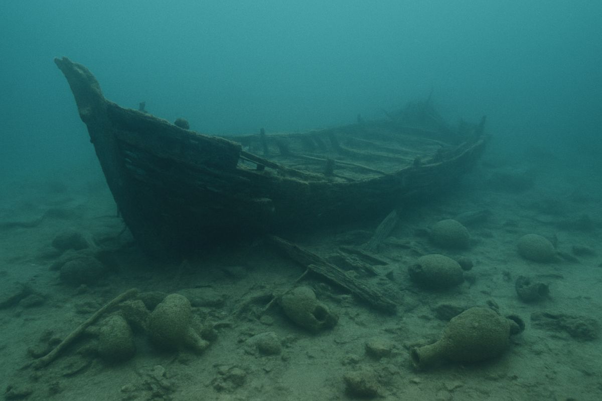
A deep-sea shipwreck in Norway, archaeologists call the “Porcelain Wreck,” has revealed hundreds of pieces of Chinese porcelain cargo and other luxury goods, offering a rare glimpse into trade networks that connected Europe and Asia during the 18th century.

The wreck was discovered about 600 meters (nearly 2,000 feet) below the surface in the Skagerrak, the body of water between Norway, Denmark, and Sweden. Researchers say the vessel and its cargo are among the best-preserved maritime finds ever recorded in Northern Europe.

Discovery beneath the seabed

The find began in September last year when professional diver Espen Saastad was conducting a routine seabed survey off the Norwegian coast. During a review of underwater footage, he noticed a shipwreck surrounded by stacks of porcelain resting on the seafloor.

The footage was sent to the Norwegian Maritime Museum, where researchers immediately recognized its significance.

“We thought it was an incredible wreck,” said Sven Ahrens, research director at the museum. “We often find cargo and freight, but it’s usually broken or covered by marine growth. Here, whole plates were lying in stacks on the seabed.”

Museum experts identified the cargo as 18th-century Chinese porcelain. The footage also revealed fragments of chandeliers, fine stemware, and other luxury items.

Rare evidence of global trade

Researchers believe the vessel was likely a galiot, a small cargo ship that operated within Northern Europe. While the ship probably never traveled to Asia, the Chinese porcelain cargo likely arrived through major trading centers such as Amsterdam, Copenhagen, or Gothenburg before being loaded onto the vessel.

The discovery provides evidence of the expanding trade networks and growing consumer culture that transformed Europe during the 18th century.

A remarkably preserved shipwreck discovered 600 meters beneath the waters off Norway has revealed hundreds of pieces of Chinese porcelain and other luxury goods dating to the 18th century. pic.twitter.com/nO5sL4SUfB

— Tom Marvolo Riddle (@tom_riddle2025) June 3, 2026

Unlike many shipwrecks found off the Norwegian coast that carried a single commodity, such as timber, fish, or iron, this vessel transported a diverse cargo of imported goods.

“The Porcelain Wreck is the first wreck we have found that demonstrates the breadth of interregional commercial activity in Northern Europe during the 18th century,” said maritime archaeologist Frode Kvalø, who leads the project.

Technology helps recover artifacts

Archaeologists have explored the wreck using a remotely operated vehicle, or ROV, controlled from a research vessel on the surface. The technology allowed researchers to create a detailed 3D model of the site and map the location of the ship and its cargo.

In May, the team recovered nearly 40 artifacts using a robotic arm equipped with specially designed suction cups. Most of the recovered objects were pieces of Chinese porcelain that appeared almost untouched despite spending centuries underwater.

One recovered brick from the ship’s galley carried a maker’s mark linked to Lübeck, Germany. Researchers are now examining historical Danish Sound Dues records in hopes of identifying the vessel and reconstructing its final voyage.

Thousands of artifacts remain

Only a small portion of the cargo has been recovered so far. Thousands of artifacts remain on the seabed, including unopened crates whose contents are still unknown.

Researchers hope the next phase of the project will involve a full archaeological excavation of the site. Such an effort could provide unprecedented insight into maritime trade, shipping practices, and daily life during a period when global commerce was rapidly expanding.

For archaeologists, the shipwreck of Norway represents more than a remarkable collection of Chinese porcelain. It offers a rare and largely untouched snapshot of the commercial world that linked continents centuries ago.

“Dig of the Century” at Notre Dame Reveals 2,000 Years of Paris History

3 June 2026 at 18:30
Notre Dame Cathedral reopens in Paris with 'Merci' projected on its facade
Notre Dame Cathedral reopens in Paris with ‘Merci’ projected on its facade. Credit: Julian Fong / CC BY-SA 2.0

Tourists stand in line under the summer sun outside Notre Dame Cathedral, waiting to climb the landmark and see its famous Roman artifacts. Just a few meters below them, archaeologists are digging into nearly 2,000 years of Parisian history.

The excavation is taking place beneath the cathedral’s forecourt as part of a project to redesign the square. Paris plans to add trees, shade, and cooling features around Notre Dame following its restoration after the devastating 2019 fire. Before work can begin, archaeologists must investigate and protect any remains buried underground.

French media have dubbed the project the “dig of the century” because of the discoveries emerging from one of the city’s most historic locations.

“It’s a rare opportunity for us to work on something that’s tangibly going to make a difference to the history of Paris,” Lucie Altenburg, a conservator with the Paris archaeology unit, told The Associated Press.

Ancient artifacts emerge

Researchers have already recovered hundreds of artifacts. One of the most important finds is a fourth-century coin depicting Roman Emperor Constantine. The coin was heavily corroded when it was unearthed, but X-ray imaging revealed the emperor’s portrait. Such finds help archaeologists date the different occupation layers beneath the cathedral.

The team has also uncovered fragments of medieval pottery marked with faint reddish inscriptions painted on the inside. Similar symbols appear on multiple shards, but experts have not yet determined their meaning.

Archaeologists digging beneath Notre Dame Cathedral have uncovered Roman-era artifacts, medieval pottery with mysterious markings and evidence of Paris' ancient past.#notredame #romanartifacts pic.twitter.com/NB7zlQJtGq

— Tom Marvolo Riddle (@tom_riddle2025) June 3, 2026

Some of the most remarkable discoveries have come from medieval latrines buried beneath houses that once crowded the area around Notre Dame. The pits served as both toilets and rubbish dumps, creating conditions that preserved everyday objects for centuries.

Archaeologists have recovered complete jugs, cups, and other ceramics that survived intact after spending hundreds of years underground. It is “rare to find complete ceramics,” said archaeologist Valentine Breloux.

Clues to Paris’ evolution

The excavation has also revealed evidence of Paris’ transformation from the Roman city of Lutetia into the medieval capital that followed.

Archaeologists discovered a Roman stone doorstep that had been removed from a larger building, turned upside down, and reused as paving in a later roadway. The find shows how residents repurposed materials as the Roman world gave way to a new era.

Once artifacts leave the site, they are transported to the city’s archaeology center, where specialists clean, catalog, and study them.

Looking deeper into the past

The work is expected to continue as Paris moves forward with plans to plant 160 trees and create a cooler, greener public square by 2028. Archaeologists hope to dig even deeper before then, searching for traces of the Gauls, the people who inhabited the area before the Roman conquest.

“The hope is that we are able to go back in time even further than we’ve ever been before,” Altenburg said.

Greek Mythology’s Mysterious Eridanos River May Point to a Real Place in Europe

3 June 2026 at 16:32
The Loire River, likely part of the Eridanos River of Greek mythology
The Loire River, likely part of the Eridanos River of Greek mythology. Credit: Wikimedia Commons, CC-BY-SA 3.0, LPLT

The Eridanos River of Greek mythology is a mysterious river whose location has long been debated. Numerous real-world rivers around Europe have been suggested, but some scholars believe it is completely mythical and corresponds to no real-world location. Nevertheless, some may wonder where this river might actually be situated.

The Eridanos River of Greek mythology

To try to understand which real-world river it might correspond to, we first need to look at what ancient sources say about it. The Eridanos River is most famous for its connection with Phaethon and amber. In the relevant legend, it’s the river into which Phaethon crashes after he steals the chariot of the sun god.

Phaethon’s sisters, the Heliades, grieved the loss of their brother, and the gods transformed them into poplar trees. These trees, in turn, supposedly produced amber for which the river was well known. Numerous scholars have attempted to use this information to identify this body of water.

Furthermore, we know that the Eridanos River cannot have been an obscure, minor river. Hesiod mentions it in his list of the offspring of Oceanus. Eridanos appears first in the list, and Hesiod even calls it “deep-swirling,” which is an expression normally reserved for the great Oceanus itself.

Where was the Eridanos River?

With these facts in mind, what have scholars argued about the location of this river? Well, one popular candidate is the Vistula River, since this flows through Poland and leads to the Baltic Sea. This was a major source of amber in the ancient world, and this fits the criterion of the Eridanos River being a source of amber.

Furthermore, Herodotus associates the Eridanos River with a certain “northern sea.” Since the Baltic Sea is to the north of Greece, it could fit Herodotus’ description. However, another popular candidate is the Po River, which flows through northern Italy and enters the Adriatic Sea. In fact, several ancient sources explicitly identify the Eridanos with this real river. At first, that might seem to settle the matter. However, it’s more complicated than that.

A closer look at Herodotus’ description

Herodotus, in the fifth century BC, was not the first person to mention the Eridanos River. As we saw earlier, that was Hesiod. However, he does seem to provide the earliest useful description of it. His description reads:

“As to the extremities of Europe towards the West, I am not able to speak with certainty: for neither do I accept the tale that there is a river called in Barbarian tongue Eridanos, flowing into the sea which lies towards the North Wind, whence it is said that amber comes; nor do I know of the real existence of the Cassiterides from which tin comes to us… However that may be, tin and amber certainly come to us from the extremity of Europe.”

As we can see from this description, the Eridanos River was explicitly said to flow into the sea which lies towards the North Wind, and Herodotus refers to this region as the “extremity of Europe”. This definitively rules out the Po River, which flows into the Adriatic Sea near Greece itself.

Does this mean that the Vistula River is the most likely candidate? At first, that might seem to match Herodotus’ reference to the “extremity of Europe” and the fact that the river flowed into the sea towards the North Wind. However, that does not work either. Herodotus prefaces this passage by referring to the “extremities of Europe towards the West”.

Since the Vistula and the Baltic Sea are essentially directly north of Greece, this does not match this aspect of Herodotus’ description.

Jason and the Argonauts

Jason and the Argonauts Disembark at Colchis, Charles de La Fosse, 1672
Jason and the Argonauts disembark at Colchis, Charles de La Fosse, 1672. Credit: Wikimedia Commons, CC-BY-SA 3.0

The Argonautica, by Apollonius Rhodius of the third century BC, reveals the answer to this conundrum. Although it contains some fictional geography, it is clear about where the Eridanos River was supposedly situated, and this aligns perfectly with Herodotus’ description.

According to Apollonius, Jason and the Argonauts sail from the Black Sea through the Danube and then reached the Adriatic Sea via a fictional channel between the two. They then sail up into the Eridanos River, actually signifying the Po River in this context. Eventually, they make it to the Rhodanus River, or the Rhone as it is known today, a body of water which flows through France relatively close to the Po River source and then spills into the the Mediterranean Sea on the country’s southern coast.

This is significant because it demonstrates that the Greeks believed the Po and the Rhone were connected. In fact, other ancient texts attest to this same belief. Consequently, this means Apollonius is presenting the Rhone as part of the Eridanus River.

How the Argonautica reveals the true location of the Eridanos River

At this point in the Argonautica, the true nature of the Eridanos River is made clear. Apollonius writes:

“Thence they entered the deep stream of Rhodanus which flows into Eridanus; and where they meet there is a roar of mingling waters. Now that river, rising from the ends of the earth, where are the portals and mansions of Night, on one side bursts forth upon the beach of Ocean, at another pours into the Ionian Sea, and on the third through seven mouths sends its stream to the Sardinian sea and its limitless bay.”

Apollonius refers to the Eridanos River as having three mouths. One arm of the river flows into the Ionian Sea, which is an ancient reference to the Adriatic Sea. That is the arm of the river that Jason and the Argonauts have just been described as sailing up. Another one of the arms of the river is said to flow into the Sardinian Sea. That would be the Rhone, in accordance with Apollonius who explicitly presents the Rhodanus (the Rhone) as part of the Eridanos.

The third arm is the final piece of the puzzle. According to Apollonius, it flows into the “beach of Ocean.” Incidentally, this matches Herodotus’s description of the Eridanos flowing into the sea on the other side of Europe, which doesn’t match the Rhone nor the Po. The notable point is that this shows that the Ancient Greeks believed the Po, the Rhone, and a third river were all part of one enormous waterway in Europe, which they referred to as the Eridanos.

What was the third arm of the Eridanos River?

A few lines later, Apollonius refers to the mouth of the river in the southern part of France as the middle of the three mouths of the Eridanos. With the Po River having the mouth closest to Greece, and the Rhone having the intermediate one, the third mouth must have been even further west. This, again, is in harmony with Herodotus’ description, which associated the Eridanos with the western extremity of Europe.

Based on this, the only plausible candidate for the third arm of the Eridanos River is the Loire. This is a river whose mouth is further west than the mouth of the Rhone. It flows out into the Atlantic Ocean on the western side of France and is located towards the north—another detail of Herodotus to keep in mind. Furthermore, it flows quite close to the Rhone near its source, making sense of the belief that they were connected.

In summary, it appears that the Greeks imagined the Loire, the Rhone, and the Po Rivers to all be connected. The Greeks received their amber via the Po River, since it was the final part of the Amber Road which originated in the Baltic Sea. However, they believed that the Po was connected to the Loire.

This perfectly matches up with Herodotus’ description of the Eridanos River in its entirety. As we saw, he claimed it flowed into the sea on the other side of Europe and associated it particularly with the north and the west, which points to the Loire.

EU targets AI, chips in fresh sovereignty drive

3 June 2026 at 15:37

The European Commission (EC) took the wraps off a sweeping new package outlining measures to boost the continent’s ambitions around semiconductors, AI, cloud and open source, as part of a bid to strengthen the bloc’s digital autonomy.

EC stated measures in the four areas will help Europe “become an AI continent”, established as a leader in research, development and adoption of AI.

It hopes the package will fast track ambitions around technology sovereignty and protect European digital independence, as part of a long-standing goal to reduce reliance on the US and Asia.

Starting with chips, the EC said it wants to secure the semiconductor base for Europe’s AI ambitions through the Chips Act 2.0, which is designed to speed up permitting, deepen cooperation with “like-minded partners” and introduce a new excellence label for Europe’s semiconductor regions.

It is an update of the original Chips Act, in force since 2023, which represented Europe’s response to vulnerabilities in the semiconductor supply chain.

Secondly, a new Cloud and AI Development Act is designed to aid the buildout of new data centres, streamline conditions for deploying facilities across the European Union (EU) and introduce a single EU-wide framework to assess cloud and AI sovereignty. The wider aim is to triple the region’s data centre capacity in the next five to seven years.

Through open source, the EC wants to strengthen digital autonomy, scaling up alternatives in priority areas, invest in skills, startups and digital infrastructure while support greater use of open source in public administration.

Finally, the EC put the focus on digitalising Europe’s energy system, pledging to define a roadmap in the sector to ensure data centres are integrated, while building sovereign and secure AI models.

Technological sovereignty
Ursula von der Leyen, president of the commission, said Europe “cannot afford to depend on others for the technologies that keep our hospitals running, our energy grids stable and our services secure”.

“This is about protecting our citizens, defending our interests and making our own choices. Europe has the talent, the research excellence, the industrial base and the Single Market. Together, we must turn these strengths into technological sovereignty.”

Before the package is put into force, the proposal will be negotiated by the European Parliament and Council of the EU. The commission will also launch a consultation process with member states.

Investment will be made through existing grants until 2028, while future funding is to be confirmed in the next EU budget. The EC has previously estimated a combined public-private investment of €120 billion by 2035 to rejuvenate the continent’s chip industry.

The post EU targets AI, chips in fresh sovereignty drive appeared first on Mobile World Live.

Ukraine strikes St. Petersburg with drones ahead of 'Russian Davos'

3 June 2026 at 13:59
Ukrainian drone attacks in St. Petersburg targeted military and energy infrastructure overnight into Wednesday, setting ablaze a Russian warship and oil depots on the Baltic coast. This attack deep in Russian territory came on the opening day of Putin's three-day economic forum held in the city and as NATO Secretary General Mark Rutte arrived in Kyiv for an unannounced visit.

UK regulator bemoans train mobile signal failures

3 June 2026 at 11:13

Ofcom called for a concerted effort from mobile operators, local authorities and other entities to improve coverage across the UK, as it published a study highlighting widespread mobile signal issues uncovered on the country’s railway network.

Its research assessed coverage on 24 segments of the UK’s key railway lines. A good performance was deemed to be a download speed of at least 5 Mb/s, 1.5 Mb/s upload, and a response time of 50 milliseconds or less.

It found EE met those standards on 42% of the lines, Virgin Media O2 hit 20%, Vodafone scored 17% and 3 UK 21%. The latter two are now the same company.

Ofcom noted the research “highlights the core problem that mobile signal from masts on the ground often isn’t strong enough around train lines and that some carriage types are difficult for signals to pass through”.

It also found on-board Wi-Fi by train companies was little help, performing well 1% of the time. This was blamed on “outdated technology” and speed caps.

Goals
Alongside the train-specific research, the regulator published a report detailing general aims to improve the quality of mobile coverage in the country.

Here, Ofcom called for a “national effort” to improve services, noting the roles of the mobile industry, local authorities, central government, building developers and landowners.

Highlighting a binding £11 billion investment commitment from VodafoneThree related to merger clearance, Ofcom expects “other networks to respond with their own investment, and collectively this will be a key driver of improvements”.

Ofcom also pointed to issues with infrastructure planning applications in some areas and the advantage of having dedicated indoor coverage systems within sites such as shopping centres.

On train-specific problems, it noted “competition between mobile networks alone won’t be enough to improve mobile signal on trains, and government is currently considering options for how it can help”.

“As well as providing technical advice to Government to help inform its approach, we’ll also look at whether more spectrum – the airwaves all wireless technology relies on – is required”.

Challenges
A statement issued by trade association Mobile UK on behalf of the country’s three mobile operators welcomed the Ofcom research, explaining it “highlights the unique structural and capacity challenges of delivering consistent connectivity on moving trains”.

Noting building the advanced infrastructure required needed “the right enabling environment” the organisation urged government action through the country’s Mobile Market Review and “planning reform to establish a supportive policy and regulatory framework”.

“Dedicated public investment is also critical to tackle complex trackside blackspots, as commercial rollout alone cannot bridge the gap on the rail network,” the statement added. “We look forward to working with Government and Ofcom to achieve this, balancing the need for major investment with Ofcom’s vital role in maintaining low costs for consumers.”

The post UK regulator bemoans train mobile signal failures appeared first on Mobile World Live.

NATO chief in Kyiv says Russia is 'increasingly desperate'

3 June 2026 at 08:26
NATO chief Mark Rutte said in Kyiv on Wednesday that Russia was growing desperate as it faced mounting military and economic difficulties in its four-year-long invasion of Ukraine. Earlier, Kyiv launched drone attacks on the Russian city of St. Petersburg where officials and visiting dignitaries were gathering for a flagship economic forum. Read about the day’s events as they unfolded on our liveblog.

❌