Normal view

Cape Tainaro in Greece: Where the Land Ends and Legends Begin

11 June 2026 at 11:31
Cape Tainaron
The tip of Cape Tainaro, where Greece’s mainland ends. Credit: GeorgiosKladis , CC BY-SA 4.0/Wikipedia

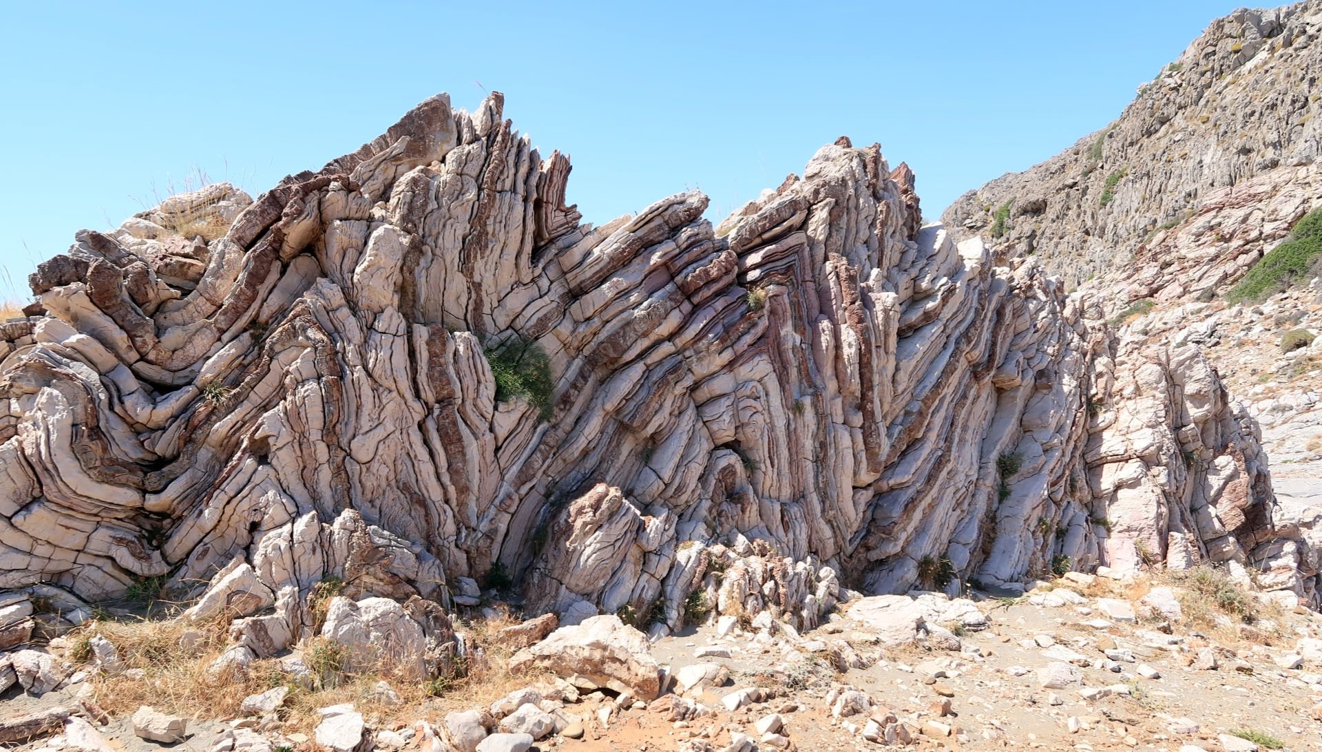
Cape Tainaro (also known as Cape Matapan) is the southernmost point of mainland Greece and the Balkan Peninsula, located at the tip of the Mani Peninsula. It’s a place of rugged beauty, characterized by dramatic cliffs, a wild landscape, and the convergence of the Messenian and Laconian Gulfs.

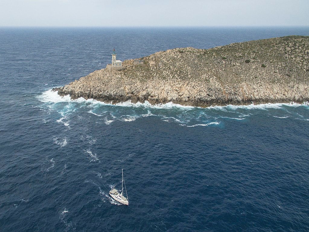
Tainaro has been important for thousands of years, serving as a maritime crossroads and a place of worship. Today, a lighthouse stands at its very tip, and scattered ruins of ancient settlements and temples can still be found there.

Cape Tainaron
The southernmost point of the Balkan Peninsula. Credit: Nicolas Hadjidimitriou, CC BY-SA 4.0 / Wikipedia

The lighthouse that stands guard in Tainaro is considered one of the most imposing in all of Greece. It is a construction of French technicians, built of stone on a plateau on the natural rocks of the cape, with a height of about 52 feet (16 meters). It began operating in 1887 and was renovated in 1930.

In 1984, an automatic lighting machine was installed there, and the lighthouse was abandoned by its last guardians. The building was restored in 2008 and has since been guarded by Navy personnel. Every third Sunday in August, public access is free as part of World Lighthouse Day.

Tainaro lighthouse.
The lighthouse at Tainaro. Credit: Nicolas Hadjidimitriou, CC BY-SA 4.0/Wikipedia.

Cape Tainaro: Gateway to the Underworld (Hades)

Ancient Greeks believed that a cave at the cape’s edge, often referred to as the “Gates of Hades” or “mouth of Taenarum,” was a direct entrance to the Underworld, the realm of the dead, ruled by the god Hades. This mythical entrance was said to be guarded by Cerberus, the monstrous three-headed hound with a serpent’s tail who prevented the dead from escaping and the living from entering.

One of the most famous myths connected to Tainaro is that of Heracles (Hercules). As his twelfth labor, he descended into the Underworld through this cave to capture and bring Cerberus to Eurystheus. The legendary musician Orpheus also used this passage to descend into Hades in his attempt to bring his beloved wife, Eurydice, back to the world of the living.

By some accounts, the sculpted canal on the east side of Porto Sternes was the path taken by the souls of the dead, ferried by Charon, the grim boatman of the Underworld.

Cape Tainaro: Sanctuary dedicated to Poseidon

Temple Poseidon
View of the temple. Credit: Katsikas pantelis , CC BY-SA 4.0/Wikipedia

Cape Tainaro was home to a sanctuary dedicated to Poseidon, the god of the sea. Poseidon was worshiped under various epithets, including “Poseidon Tainarios,” as the god who controlled both the seas and earthquakes.

The temple served as a place of inviolable asylum, offering refuge to criminals and even escaped slaves. A story was recounted by Thucydides about the Spartans violating this asylum by killing helots (agrarian slaves) who had taken refuge there, an act believed to have brought divine retribution in the form of an earthquake.

Tainaron Poseidon
A Roman mosaic at the Temple of Poseidon at Tainaro. Credit: Nicolas Hadjidimitriou , CC BY-SA 4.0/Wikipedia

The site also functioned as a “necromanteion,” or Oracle of the Dead, where Ancient Greeks would perform rituals to communicate with the spirits of their deceased ancestors, seeking guidance or prophecy.

A celebrated bronze statue of the poet and singer Arion, seated on a dolphin, was a prominent dedicatory offering at the temple of Poseidon. It honors the myth of Arion, who was rescued by a dolphin after being cast into the sea by pirates and brought safely to Cape Tainaron.

In medieval times, Tainaro became a notorious pirate base—with merchant ships carefully avoiding it—and during World War II, the Battle of Tainaro (March 1941) was fought off the coast between the British and Italian fleets.

Getting to Tainaro

The only way to get to Tainaro is by hiking along a path that many consider to be the most interesting of the “inner” Mani. It is accessible to all with no significant altitude differences and has a total length of about 1.4 miles. Starting from the village of Kokkinogia, it’ll probably take around fifty minutes to get to the lighthouse.

You will find the village of Kokkinogia at the end of the Areopolis-Tainaro road. The marked dirt path begins at the church of Agioi Asomatoi and passes by the beach of Aria, where you can see a Roman mosaic. The surrounding landscape is typical of Mani: thorn bushes, thyme, low vegetation, flint stones, and no shade—so be sure to wear a hat, apply sunscreen, and bring plenty of water. The views along the way to Tainaro will make it all worthwhile.

Geology of Greece: How the Country’s Beautiful Landscape Formed

By: guest
10 June 2026 at 10:16
Greece geology landscape
A stunningly unique phenomenon of geology in Greece: The Folded Marls near Agios Pavlos, on the island of Crete. Credit: Tony Cross.

By Tony Cross

Greece and its geology are a wonder of nature, with the nation a paradise blessed with high mountains, blue seas, and over six thousand islands. But it’s all a big geological accident, the result of millions of years of violent earth movements on a planetary scale.

Geology in Greece: in the beginning…

The story of Greece and its geology begins around 250 million years ago when the continents had all come together into one single land mass that geologists call Pangea.

The area that would one day become Greece lay on the southern shore of what would eventually become Europe and on the northern edge of a great ocean called Tethys. On the southern edge of Tethys lay the continent that would one day become Africa.

The Earth’s crust is not all the same, nor is it a single unit. The crust making up the continents is very thick—30 km to 40 km (18.6 to 24.85 miles) thick—and thicker still under mountain ranges. The crust under the oceans is quite thin, however, at only around 7 km (4.3 miles) thick.

In addition, the crust is not one single unit but is broken up into various-sized chunks known as tectonic plates. These plates move relative to one another because they are literally floating on the deformable layer of the upper mantle beneath them in much the same way that a ship floats on the sea.

In some places, these plates are moving together, and where oceanic crust is pushed into continental crust, the thinner oceanic crust is forced beneath the thicker continental crust and down into the mantle, where it begins to sink and melt. Geologists call this type of plate boundary a subduction zone.

The Greek landscape and geology that we see today is here because of a subduction zone. Without it, Greece would simply not exist.

The compressive phase

Around 150 million years ago, the great continent of Pangea started to break up. The African plate began to move northwards, and the Tethys Ocean started to shrink. The northwards movement of Africa meant that the oceanic crust beneath Tethys was subducted under the southern edge of the continental crust of Europe.

As the oceanic crust under Tethys slid beneath the continental crust of Europe, all of the rocks that had formed on the ocean floor over many millions of years were scraped off by the leading edge of the European continent. These rock scrapings, which would have been hundreds of meters thick and many kilometers long, were piled up one on top of the other on the southern edge of Europe.

This rock pile (geologists call it a nappe) was likely many kilometers thick in the end. It contained all the rocks that would eventually form Greece’s geology all piled up in the same place.

Greece geology landscape
A thrust fault near Kavousi, Crete. Credit: Tony Cross.

The photo shown here is of a large sea cliff near Kavousi on Crete. The rocks on the left are a gray color with clearly defined horizontal layers. Those on the right are a greenish brown color with a nearly vertical layering. Clearly, this cliff is composed of two very different rock types.

The rocks on the left are limestones while those on the right are phyllites. The compressional forces of the subduction zone forced the phyllites over and on top of the limestones. The junction between the two (known as a thrust fault) lies roughly in the center of the picture, running diagonally up from right to left.

Millions of years of weathering and erosion have ground both sets of rocks down so that to the casual observer today, they appear to be a single unit.

The tensional phase

Around 65 million years ago, the continent of Africa finally collided with the continent of Europe and closed the Tethys Ocean forever. It would eventually be reborn as the Mediterranean Sea.

When two continental plates come together, there is no subduction since they are both too thick. Instead, the continents themselves are deformed, and mountains are created. In the west, this collision formed the Alpine mountains while in it formed the Balkan mountains in the east.

In these mountain areas, the continental collision destroyed the subduction zone, but in the area in between, where modern Greece lies, the subduction zone remained active.

Even though Africa could no longer move northwards as fast as was previously the case, the oceanic plate in the area of Greece was still sinking into the mantle. As it sank, the subduction zone itself rolled back southwards. This rollback of the subduction zone put the nappe pile under enormous tension.

When rocks are placed under tension, they break, causing normal faults. One side of the fault moves downwards on a sloping surface to relieve the tension. Normal faults often occur in parallel and in swarms leaving alternating areas of high ground with lower ground in between.

The rollback of the subduction zone caused massive parallel swarms of normal faults in the nappe pile. Because the subduction zone is fixed in the east and in the west, the rollback created an arc that is ever expanding as the rollback progresses.

Greece geology landscape
A normal fault in the Corinth Canal. Credit: Tony Cross

The photo above is of a small section of the north wall of the Corinth Canal. The rocks here are nicely layered; we can see yellow, white, red, and black layers.

The two diagonal lines in these rocks are normal faults, breaks in the rocks caused by tensional forces due to the rollback of the subduction zone. The rocks to the right of each fault have dropped down relative to the rocks on the left; this is clearly visible in the displacement of the colored layers of rock.

The total vertical displacement here is only a few meters, but in the massive regional faulting that shaped Greece and its geology, displacements are measured in kilometers.

The modern topography of Greece

Looking at a topographical map of Greece today, you can see how a subduction zone, starting roughly in the area of the north Aegean and rolling back southwards in an expanding arc would create the “ripped” and “torn” appearance of Greece today. You can also see how regional faulting created the alternating series of high mountain ranges and islands, with lower plains or sea in between.

The Pindus Mountains, for example, the backbone of mainland Greece, run southeastward in a gently curving arc. On both sides are lower plains. These mountains, like so many others in Greece, are bounded by massive regional faults.

The expanding arc of the subduction zone caused extensive local faulting, too. On Crete, for example, all of the mountain ranges are bounded by faults. They stand tall because the ground around them has dropped due to faulting. Such local, fault-bounded structures are widespread in Greece.

What about the volcanoes?

There are many volcanoes in Greece—on Santorini, Milos, Nisiros, Methana, and Sousaki among others. Some are active, like Santorini; most are dormant, like Milos, and one or two are extinct, like Sousaki.

If you look closely, all the Greek volcanoes sit on an arc that parallels the arc of the subduction zone but is north of it by about 100 km.

As the oceanic plate is subducted deep into the mantle, it begins to melt. Magma from the melting plate rises to the surface where it erupts, forming volcanoes.

The hot springs of Thermoplyae (of Spartan fame) sit at one end of this volcanic arc; the hot springs of Pamukkale in Turkey sit at the other. In between are all the Greek volcanoes, formed above the spot where, deep in the mantle, the subducted oceanic crust is melting.

Greece’s geology continues to change

The subduction zone today runs in a great arc down the western side of the Ionian Islands, around the Peloponnese and south of Crete, and then curves up northwards again past Kasos, Karpathos, and Rhodes.

Greece and its geology as we see these today are not an end point, however; this is simply the way things are right now.

The subduction zone is still active, and the oceanic plate is still descending as Africa creeps northward. The subduction zone is still rolling back, and the arc is still expanding. That’s why we have so many earthquakes in Greece—we’re still being torn apart by tectonic forces.

We don’t need to worry about this too much though, as these geological processes happen on a timescale that is measured in millions of years. Chances are, that beautiful Greek beach in the travel brochure will still be there when you arrive.

❌